 My GeoNetwork catalogue
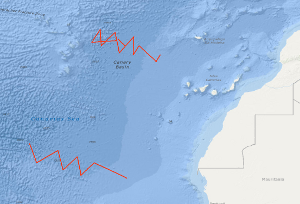
Processed seismic data of Cruise BGR88 1988
In continuation of a fracture zone survey of BGR in 1985, there was a multichannel seismic survey of the Hayes Fracture Zone between 20°W and 27°W in the time from October 26th to November 11th, 1988. In spite of bad weather conditions, it was possible to collect a total of 1.760 km seismic and gravity data on 11 lines. From a first interpretation of the seismic monitor records on board it appears that the frequency of intra-crustal reflections in the records from the area west of 20°W is much less than on the records of the survey of the previous cruise in 1985. During a second leg in the time period from 14th November to 21th November 1988 an additional seismic survey of the Kane Fracture Zone took place with 7 supplementary profiles.
Simple
- Alternate title
-
BGR88 1988
- Date (Creation)
- 1988-11-21
- Citation identifier
- 58ebdb27-97da-f81c-4021-122d375522cc
- Status
- Completed
-
GEMET - INSPIRE themes, version 1.0
-
-
Geologie
-
geology
-
-
GEMET - Concepts, version 2.4
-
-
geophysics
-
Geophysik
-
raw material
-
Rohstoff
-
- Theme
-
-
Marine geology
-
Meeresgeologie
-
Seismics
-
Seismik
-
Two-dimensional seismic reflection
-
zweidimensionale Reflektionsseismik
-
- Place
-
-
West Africa
-
Westafrika
-
Canary Basin
-
Kanarenbecken
-
Hayes Fracture Zone
-
Kane Fracture Zone
-
- Access constraints
- Other restrictions
- Other constraints
- Es gelten keine Zugriffsbeschränkungen
- Use constraints
- Other restrictions
- Other constraints
-
Allgemeine Geschäftsbedingungen, siehe http://www.bgr.bund.de/AGB - General terms and conditions, see http://www.bgr.bund.de/AGB_en . Die bereitgestellten Informationen sind bei Weiterverwendung wie folgt zu zitieren: Datenquelle: BGR88 1988, (c) BGR, Hannover, 1988
- Spatial representation type
- Vector
- Language
- English
- Character set
- UTF8
- Topic category
-
- Geoscientific information
))
- Unique resource identifier
- EPSG:4326
- Distribution format
-
-
Shapefile
(
n/a
)
-
Shapefile
(
n/a
)
- Transfer size
- 2
- OnLine resource
-
BGR88 1988 (Shapefile)
BGR88 1988 im Format ESRI Shape
- OnLine resource
- Karte im BGR-Geoviewer
- Hierarchy level
- Dataset
Conformance result
- Date (Publication)
- 2010-12-08
- Explanation
-
siehe dazu die angegebene Durchführungsbestimmung
- Statement
-
During the period from the 26th October to the 21th November 1988 BGR acquired seismic lines off West Africa in the Canary Basin at the Hayes and Kane Fracture Zones. All lines from BGR88-01 to BGR88-18 consist of raw data.
- File identifier
- 6d45ccca-5b69-420b-b65f-45ab73e27b3a XML
- Metadata language
- English
- Character set
- UTF8
- Parent identifier
-
Marine Seismic Survey Profiles (MSSP)
06a73c56-06a2-40d8-b806-466222b0760d
- Hierarchy level
- Dataset
- Hierarchy level name
-
Geophysik
- Date stamp
- 2023-11-14
- Metadata standard name
-
INSPIRE Metadata Implementing Rules: Technical Guidelines based on EN ISO 19115 and EN ISO 19119
- Metadata standard version
-
n/a
Overviews
Spatial extent
Provided by
