 www.geodatenkatalog.de (S1L)
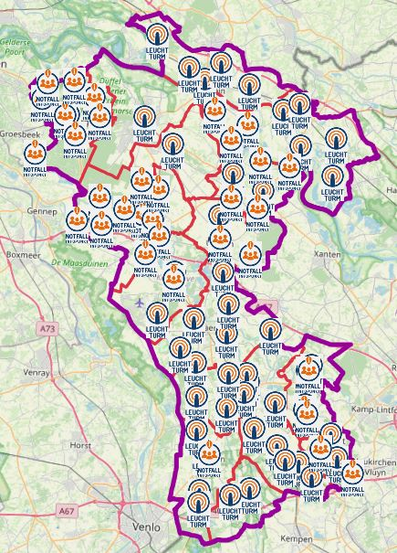
Geoportal - Notfallanlaufstellen im Kreis Kleve
Das Geoportal "Anlaufstellen bei einem Blackout im Kreis Kleve" zeigt die Notfallanlaufstellen, welche z.B. aufgrund einer Energiemangellage, aufgesucht werden können.
Es handelt sich um keine dauerhafte Einrichtungen und werden von den Städten und Gemeinden bei Bedarf im Fall eines Notfalls besetzt.
Das Geoportal kann auf einem Smartphone benutzt werden, es enthält eine Locate me Funktion.
Diese Funktion zeigt ihren Standpunkt. Somit ist die nächste Notfallanlaufstelle in der Karte ersichtlich.
Die Notfallanlaufstellen werden unterteilt in:
- Leuchttürme
- Notfall-Infopunkte
- Notrufstellen
Zur besseren Orientierung werden Hintergrunddaten angeboten.
Zu den Hintergrundkarten zählen:
- Die Gebietsabgrenzungen der Kommunen im Kreis Kleve sowie der Umring des Kreises Kleve.
- Die topografischen Karten DTK schwarz/weiss, DTK farbig und OpenStreetMap.
- Die aktuellen Luftbilder vom Land NRW.
|
|
Citation proposal
(2023) . Geoportal - Notfallanlaufstellen im Kreis Kleve. Kreis Kleve - Der Landrat https://gdk.gdi-de.org/geonetwork/srv/api/records/6d62a166-e490-4c72-b1ce-dafb3f2e3310 |
- Identification
- Distribution
- Quality
- Spatial rep.
- Ref. system
- Content
- Portrayal
- Metadata
- Md. constraints
- Md. maintenance
- Schema info
Identification
Data identification
Citation
- Date ( Publication )
- 2023-04-20T00:00:00.000+02:00
Publisher
Point of contact
Maintenance information
- Maintenance and update frequency
- As needed
- Update scope
- application
- Keywords
-
- Geoportal
- Kreis Kleve
- Leuchtturm
- Leuchttürme
- Notfall
- Notfallinfopunkt
- Notfall-Infopunkt
- Notrufstelle
- Blackout
- 112
- Bedburg-Hau
- Emmerich am Rhein
- Emmerich
- Geldern
- Goch
- Issum
- Kalkar
- Kerken
- Wallfahrtsstadt Kevelaer
- Kevelaer
- Kranenburg
- Kleve
- Rees
- Rheurdt
- Straelen
- Uedem
- Wachtendonk
- Weeze
- NW
- NRW
- Nordrhein-Westfalen
- 05154
- Energiemangellage
- Notfallanlaufstellen
- Anlaufstellen
Legal constraints
- Use constraints
- Other restrictions
Legal constraints
- Access constraints
- otherRestrictions Other restrictions
- Metadata language
- German
Extent
Bounding Polygon
- Extent type code
- true
Geographic description
- Extent type code
- true
- Geographic identifier
- Kleve, Kreis (05154)
))
Distribution
Distribution
- Distribution format
-
- ()
- OnLine resource
- Anlaufstellen bei einem Blackout im Kreis Kleve
Metadata
Metadata
- File identifier
- 6d62a166-e490-4c72-b1ce-dafb3f2e3310 XML
- Metadata language
- German
- Character set
- UTF8
- Hierarchy level
- application application
- Hierarchy level name
- application
- Date stamp
- 2025-04-01
- Metadata standard name
- ISO19115
- Metadata standard version
- 2003/Cor.1:2006
Point of contact
Overviews
Provided by
