 www.geodatenkatalog.de (S3L)
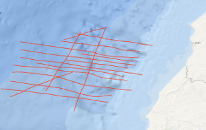
Processed seismic data of Cruise ME46 1977
During METEOR-Westafrica cruise 46, leg 1, geophysical measurements were carried out off Morocco between 31°30'N and 32°30'N in the time period from the 8th October to the 5th November 1977. Altogether 1,855 km of 24-fold reflection seismic data were collected on lines ME46-02 to ME46-11 and on lines ME46-14 to ME46-19. For the purpose of planning the programme, the reflection seismic data were processed (12-fold stack) aboard. 3,465 km of magnetic, gravimetric and bathymetric data were collected on lines ME46-01 to ME46-26 using the new BGR digital recording system. Along lines ME46-101 and ME46-102 with a total length of 209 km refraction seismic measurements were carried out with 6 moored telemetric buoys. A total of 164 shots with charges of 5 kg up to 200 kg were fired along the two lines in distances of about 1.5 km. A distinct fault zone was discovered in the area of investigation which is associated with a positive magnetic anomaly. The fault zone strikes NNE-SSW and probably marks the ocean-continent boundary. Beside diapiric structures (salt) allochthonous structures - thrust structures - are widespread features east of the discovered fault zone and below the lower continental slope. The seismic data indicate that the evolution of the old continental margin of the East Atlantic was also controlled by large scale gravity tectonics.
|
|
Citation proposal
. Processed seismic data of Cruise ME46 1977. https://gdk.gdi-de.org/geonetwork/srv/api/records/6f5d7176-cb85-44ac-989e-79fa7a7dba6b |
INSPIRE
Identification
- File identifier
- 6f5d7176-cb85-44ac-989e-79fa7a7dba6b XML
- Hierarchy level
- Dataset
Online resource
Resource identifier
- code
- ab6cf89b-95bf-cfc6-93c8-6586f39bb455
- Metadata language
- English
- Spatial representation type
- Vector
Encoding
- Format
- Shapefile
- Version
- n/a
Projection
Classification of data and services
- Topic category
-
- Geoscientific information
Classification of data and services
Coupled resource
Coupled resource
Classification of data and services
Coupled resource
Coupled resource
Keywords
- GEMET - INSPIRE themes, version 1.0 ( Theme )
-
- Geologie
- geology
- GEMET - Concepts, version 2.4 ( Theme )
-
- geophysics
- Geophysik
- raw material
- Rohstoff
Other keywords
- Keywords ( Theme )
-
- Marine geology
- Meeresgeologie
- Seismics
- Seismik
- Two-dimensional seismic reflection
- zweidimensionale Reflektionsseismik
- Keywords ( Place )
-
- Morocco
- Marokko
- Central East Atlantic
- Zentraler Ostatlantik
Geographic coverage
N
S
E
W
))
Temporal reference
Temporal extent
Temporal extent
- Date ( Creation )
- 1977-11-04
Quality and validity
- Lineage
- During the period from the 8th October to the 5th November 1977 BGR acquired seismic lines off Morocco. All lines ME46-02 to ME46-19 consist of raw data.
Conformity
Conformity
Conformity
Conformity
Conformity
Conformity
- Explanation
- siehe dazu die angegebene Durchführungsbestimmung
Restrictions on access and use
- Access constraints
- Allgemeine Geschäftsbedingungen, siehe http://www.bgr.bund.de/AGB - General terms and conditions, see http://www.bgr.bund.de/AGB_en. Die bereitgestellten Informationen sind bei Weiterverwendung wie folgt zu zitieren: Datenquelle: ME46 1977, (c) BGR, Hannover, 1977
Restrictions on access and use
Responsible organization (s)
Contact for the resource
- Organisation name
- Federal Institute for Geosciences and Natural Resources
- Marine_Seismik@bgr.de
Responsible organization (s)
Contact for the resource
- Organisation name
- Federal Institute for Geosciences and Natural Resources
- Marine_Seismik@bgr.de
Metadata information
Contact for the metadata
- Organisation name
- Bundesanstalt für Geowissenschaften und Rohstoffe (BGR)
- Date stamp
- 2023-11-14
- Metadata language
- English
- Character set
- UTF8
SDS
Conformance class 1: invocable
Access Point URL
Endpoint URL
Technical specification
Conformance class 2: interoperable
Coordinate reference system
Quality of Service
Access constraints
Limitation
Use constraints
Limitation
Responsible custodian
Contact for the resource
Conformance class 3: harmonized
Overviews
Provided by

Views
6f5d7176-cb85-44ac-989e-79fa7a7dba6b
Access to the portal
Read here the full details and access to the data.
Associated resources
Not available