 www.geodatenkatalog.de (S3L)
Karte von Berlin 1:5000 (K5 Farbausgabe)
Landeskartenwerk mit administrativen Grenzen, Flurstücksgrenzen, Straßennamen, Grundstücksnummern,
Flächen der tatsächl. Nutzung. Hergestellt von den Vermessungsstellen der Bezirke auf Basis des
Amtlichen LiegenschaftsKatasterInformationsSystems (ALKIS).
|
|
Citation proposal
(2025) . Karte von Berlin 1:5000 (K5 Farbausgabe). https://gdk.gdi-de.org/geonetwork/srv/api/records/726801d3-167d-37ea-8233-e26a5707a5a9 |
INSPIRE
Identification
- File identifier
- 726801d3-167d-37ea-8233-e26a5707a5a9 XML
- Hierarchy level
- Service
Online resource
Resource identifier
Encoding
- Format
- Text/HTML
- Version
- 4.01
- Specification
- Keine Angabe
Projection
Classification of data and services
Classification of data and services
- Service Type
- view
- Coupling Type
- Tight
Coupled resource
Coupled resource
Classification of data and services
- Service Type
- view
- Coupling Type
- Tight
Coupled resource
Coupled resource
Keywords
- Räumlicher Anwendungsbereich ( Theme )
Other keywords
- Keywords ( Theme )
-
- open data
- opendata
- Sachdaten
- Karten
- Geodaten
- Berlin
- Rasterkarte
- Kartenblätter
- 1:5.000
- ALK
- ALKIS
- K5
- Geobasiskarte
- Topografie
- Topographie
- Übersichtskarte
- Hintergrundkarte
- Grundkarte
- topographisch
- topografisch
- Keywords
-
- infoMapAccessService
Geographic coverage
N
S
E
W
))
Temporal reference
Temporal extent
Temporal extent
- Date ( Publication )
- 2025-05-22
- Date ( Revision )
- 2025-01-01
Quality and validity
Conformity
Conformity
Conformity
Conformity
Conformity
Conformity
Restrictions on access and use
Restrictions on access and use
- Access constraints
- Nutzungsbedingungen: Für die Nutzung der Daten ist die Datenlizenz Deutschland - Namensnennung - Version 2.0 anzuwenden. Die Lizenz ist über https://www.govdata.de/dl-de/by-2-0 abrufbar. Der Quellenvermerk gemäß (2) der Lizenz lautet "Geoportal Berlin / [Titel des Datensatzes]". Werden auch Daten des Bundeslandes Brandenburg genutzt, ist der Quellenvermerk um den Hinweis "© GeoBasis-DE/LGB (2023), dl-de/by-2-0, Daten geändert" zu ergänzen.
- Access constraints
- {"id":"dl-by-de/2.0","name":"Datenlizenz Deutschland - Namensnennung - Version 2.0","url":"https://www.govdata.de/dl-de/by-2-0","quelle":"Geoportal Berlin / [Titel des Datensatzes]"}
Responsible organization (s)
Contact for the resource
- Organisation name
- Bezirksamt Neukölln von Berlin
- Organisation name
- Bezirksamt Friedrichshain-Kreuzberg von Berlin
- Organisation name
- Senatsverwaltung für Stadtentwicklung, Bauen und Wohnen Berlin
- Organisation name
- Bezirksamt Tempelhof-Schöneberg von Berlin
- Organisation name
- Senatsverwaltung für Stadtentwicklung, Bauen und Wohnen Berlin
Metadata information
Contact for the metadata
- Organisation name
- Senatsverwaltung für Stadtentwicklung, Bauen und Wohnen Berlin
- Date stamp
- 2025-11-19T00:00:00Z
- Metadata language
- German
SDS
Conformance class 1: invocable
Access Point URL
Endpoint URL
Technical specification
Conformance class 2: interoperable
Coordinate reference system
Quality of Service
Access constraints
- Access constraints
- Other restrictions
Limitation
Use constraints
Limitation
- string
- Nutzungsbedingungen: Für die Nutzung der Daten ist die Datenlizenz Deutschland - Namensnennung - Version 2.0 anzuwenden. Die Lizenz ist über https://www.govdata.de/dl-de/by-2-0 abrufbar. Der Quellenvermerk gemäß (2) der Lizenz lautet "Geoportal Berlin / [Titel des Datensatzes]". Werden auch Daten des Bundeslandes Brandenburg genutzt, ist der Quellenvermerk um den Hinweis "© GeoBasis-DE/LGB (2023), dl-de/by-2-0, Daten geändert" zu ergänzen.
- string
- {"id":"dl-by-de/2.0","name":"Datenlizenz Deutschland - Namensnennung - Version 2.0","url":"https://www.govdata.de/dl-de/by-2-0","quelle":"Geoportal Berlin / [Titel des Datensatzes]"}
Responsible custodian
Contact for the resource
Conformance class 3: harmonized
Contains Operations
- Operation Name
- GetCapabilities
- Distributed Computing Platforms
- Web services
- Connect Point
- https://gdi.berlin.de/services/wmts/k5_farbe
Overviews
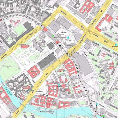
Vorschaubild
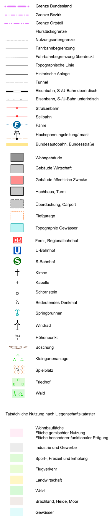
Legende
Provided by

Views
726801d3-167d-37ea-8233-e26a5707a5a9
Access to the portal
Read here the full details and access to the data.
Associated resources
Not available