 www.geodatenkatalog.de (S1L)
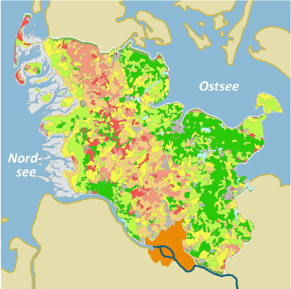
Bodengefährdung - Winderosionsgefährdung nach DIN 19706
Natürliche (potentielle) Winderosionsgefährdung nach DIN 19706 (2013-02) bezogen auf die Nettofeldblockfläche (ohne Landschaftselemente (meist Knicks oder kleine Gehölze) und ohne nicht beihilfefähige Flächen (oft Teiche o. ä.)). Berechnung auf der Grundlage von Daten zur Oberbodenart, den Windverhältnissen und den Windhindernissen. Die Karte wird in drei Maßstäben Vertrieben: Feldblockbezogen (bis 1:199.999), Übersichtskarten in den Maßstabsbereichen 1:200.000-999.999, sowie ab 1:1 Mio.
|
|
Citation proposal
. Bodengefährdung - Winderosionsgefährdung nach DIN 19706. https://gdk.gdi-de.org/geonetwork/srv/api/records/73f57fb5-9c85-4bb5-a8ea-aca679325230 |
INSPIRE
Identification
- File identifier
- 73f57fb5-9c85-4bb5-a8ea-aca679325230 XML
- Hierarchy level
- dataset Dataset
Online resource
Resource identifier
- Metadata language
- German
- Spatial representation type
- Vector
Encoding
- Format
- Shapefiles
Projection
Classification of data and services
- Topic category
-
- Environment
- Farming
- Geoscientific information
Classification of data and services
Coupled resource
Coupled resource
Classification of data and services
Coupled resource
Coupled resource
Keywords
Other keywords
- Keywords
-
- Bodenabtrag
- gdi-sh
- Bodengefährdung
- Winderosionsgefährdung
- Winderosion
- Erosionsgefärdung
- Erosion
- Bodenerosion
- DIN 19706
- Karten
- opendata
- Keywords ( Theme )
-
- ENVI
Geographic coverage
N
S
E
W
))
Temporal reference
Temporal extent
Temporal extent
- Date ( Revision )
- 2025-01-31T00:00:00.000+01:00
Quality and validity
- Lineage
- Die Berechnung erfolgt anhand der Daten der Bodenschätzung, der bodenkundlichen Landesaufnahme, den jeweils aktuellen Daten zu Windhindernissen aus dem ATKIS DGM25 des LVermGeo-SH, landwirtschaftlichen Flächenkatasters (LFK) des MELUND-SH sowie des Biotoptypenkatasters des LLUR-SH sowie Daten zu den Windverhältnissen des DWD unter Anwendung der DIN 19706 (2013-02).
Conformity
Conformity
Conformity
Conformity
Conformity
Conformity
- Explanation
- Anforderungen an Metadaten gemäß Verordnung (EG) Nr. 1205/2008 zur Durchführung der INSPIRE-Richtlinie hinsichtlich Metadaten (http://eur-lex.europa.eu/LexUriServ/LexUriServ.do?uri=OJ:L:2008:326:0012:0030:DE:PDF) mit GDI-DE Testsuite überprüft.
Restrictions on access and use
- Access constraints
- Datenlizenz Deutschland Namensnennung 2.0
- Access constraints
- Quellenvermerk: LfU-SH
- Access constraints
- {"id":"dl-by-de/2.0","name":"Datenlizenz Deutschland Namensnennung 2.0","url":"https://www.govdata.de/dl-de/by-2-0","quelle":"LfU-SH"}
Restrictions on access and use
Responsible organization (s)
Contact for the resource
- Organisation name
- Landesamt für Umwelt des Landes Schleswig-Holstein (LfU)
Responsible organization (s)
Contact for the resource
- Organisation name
- Landesamt für Umwelt des Landes Schleswig-Holstein (LfU)
Metadata information
Contact for the metadata
- Organisation name
- Landesamt für Umwelt des Landes Schleswig-Holstein (LfU)
- jan.willer@lfu.landsh.de
- Date stamp
- 2025-08-06
- Metadata language
- German
SDS
Conformance class 1: invocable
Access Point URL
Endpoint URL
Technical specification
Conformance class 2: interoperable
Coordinate reference system
Quality of Service
Access constraints
Limitation
Use constraints
Limitation
Responsible custodian
Contact for the resource
Conformance class 3: harmonized
Overviews
Vorschaubild
Provided by

Views
73f57fb5-9c85-4bb5-a8ea-aca679325230
Access to the portal
Read here the full details and access to the data.
Associated resources
Not available