 www.geodatenkatalog.de (S1L)
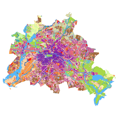
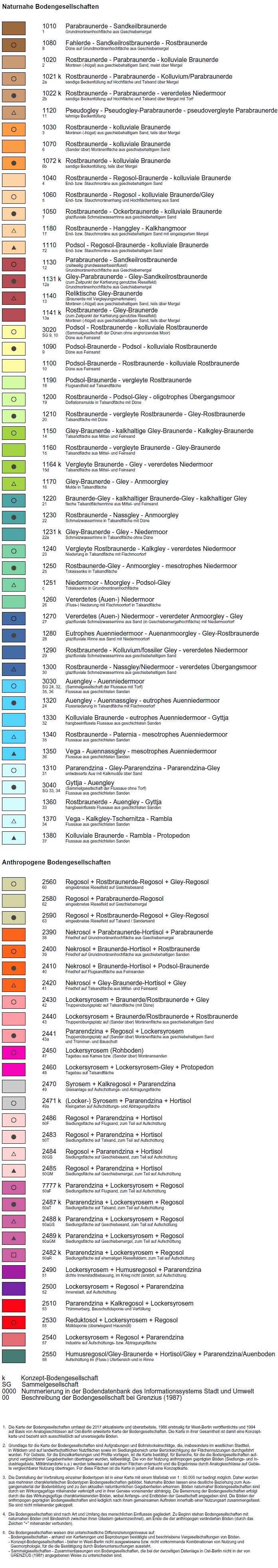
Bodengesellschaften 2015 (Umweltatlas)
Darstellung von insgesamt 76 Bodengesellschaften unversiegelter Böden, Konzeptkarte ermittelt aus Bodenuntersuchungen und Nutzungsarten auf Block- und Blockteilflächen-Basis, 1 : 5.000, Stand 2015.
|
|
Citation proposal
(2019) . Bodengesellschaften 2015 (Umweltatlas). https://gdk.gdi-de.org/geonetwork/srv/api/records/7854928f-4f7d-305f-a37c-6d20738a5673 |
- Identification
- Distribution
- Quality
- Spatial rep.
- Ref. system
- Content
- Portrayal
- Metadata
- Md. constraints
- Md. maintenance
- Schema info
Identification
Identification info
Service Identification (19119)
Citation
- Date ( Creation )
- 2018-08-13
- Date ( Publication )
- 2019-02-22
- Presentation form
- Digital map
Point of contact
Point of contact
- Maintenance and update frequency
- Not planned
- Keywords ( Theme )
-
- open data
- opendata
- Karten
- Sachdaten
- Geodaten
- Berlin
- Boden
- Bodentypen
- Bodenkarte
- Bodenarten
- Bodengesellschaften
- Umweltatlas
- Konzeptbodenkarte
- Ausgangsmaterial
- Substrattypen
- Bodenkundliche Kennwerte
- Grobboden
- Feinboden
- Oberboden
- Unterboden
- Torfarten
- Sand
- Schluff
- Ton
- Räumlicher Anwendungsbereich ( Theme )
- Keywords
-
- infoMapAccessService
Legal constraints
- Access constraints
- Other restrictions
Legal constraints
- Use constraints
- Other restrictions
- Other constraints
- Für die Nutzung der Daten ist die Datenlizenz Deutschland - Zero - Version 2.0 anzuwenden. Die Lizenz ist über https://www.govdata.de/dl-de/zero-2-0 abrufbar.
- Other constraints
- {"id":"dl-zero-de/2.0","name":"Datenlizenz Deutschland - Zero - Version 2.0","url":"https://www.govdata.de/dl-de/zero-2-0"}
- Service Type
- view
- Service Version
- OGC:WMS 1.0.0
- Service Version
- OGC:WMS 1.1.0
- Service Version
- OGC:WMS 1.1.1
- Service Version
- OGC:WMS 1.3.0
Extent
N
S
E
W
))
Geographic description
- Extent type code
- true
- Geographic identifier
- 110000000000
- Coupling Type
- Tight
Contains Operations
- Operation Name
- GetCapabilities
- Distributed Computing Platforms
- Web services
- Operates On
Distribution
Distribution
- Distribution format
-
-
Text/HTML
(4.01 )
- Specification
- Keine Angabe
-
Text/HTML
(4.01 )
- OnLine resource
-
Darstellungsdienst - Bodengesellschaften 2015 (Umweltatlas) (WMS)
Darstellungsdienst - Bodengesellschaften 2015 (Umweltatlas) (WMS)
- OnLine resource
-
Darstellung der Karte im Geoportal Berlin
Darstellung der Karte im Geoportal Berlin
Quality
Scope
- Hierarchy level
- Service
- Other
- Dienst
Ref. system
- Reference system identifier
- http://www.opengis.net/def/crs/EPSG/0/25833
Metadata
Metadata
- File identifier
- 7854928f-4f7d-305f-a37c-6d20738a5673 XML
- Metadata language
- German
- Character set
- UTF8
- Hierarchy level
- Service
- Hierarchy level name
- Bodengesellschaften und Bodenarten 2015 (Umweltatlas) Dienst
- Date stamp
- 2025-11-19T00:00:00Z
- Metadata standard name
- ISO 19115/19119 - BE
- Metadata standard version
- 1.0.0
Point of contact
Overviews
Vorschaubild
Legende
Provided by

Views
7854928f-4f7d-305f-a37c-6d20738a5673
Access to the portal
Read here the full details and access to the data.
Associated resources
Not available