 www.geodatenkatalog.de (S3L)
Processed seismic data of Cruise VA16 1977
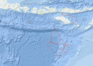
The northwestern Australian continental margin can be considered as a passive continental margin of the rifted atlantic type (Whitworth 1969; Powell 1973, 1976; Falvey 1974; Veevers 1974; Willcox 1974, 1976; Exon et al. 1975) which are usually associated with heavy accumulation of sediments (Beck et al. 1974) and are therefore of interest for hydrocarbon exploration in the longer term. The Federal Institute for Geosciences and Natural Resources (BGR, Hannover, Germany) has conducted geoscientific surveys at various continental margins of the Atlantic Ocean in the past years (Seibold 1972; Hinz et al. 1973; Seibold, Hinz 1974/1976; Seibold et al. 1975; Roeser et al. 1971) and the marine research programme of the Bureau of Mineral Resources, Geology & Geophysics (BMR, Canberra, Australia) is putting the focal point as well on the survey of the continental margins. Hence in the frame of the Australian-German contract of scientific and technical cooperation, BGR has proposed joint geoscientific surveys of the continental margins with the German research vessel VALDIVIA. The Scott-Plateau (NW-Australia) has been chosen as investigation area because BMR has carried out geophysical overview measurements previously in that region. The survey has been planned with the main focus on the geological processes at the early rift stadium and the set of problems about the "transition of oceanic to continental crust". The following regional geological units are known: the archaic-proterozoic Kimberley shield is followed by the Browse Basin - a NE striking epicontinental basin filled with mesozoic and tertiary sediments showing a thickness of up to 10 km (Powell 1976). It is presumed that the Browse Basin is delimitated by the Scott Plateau. Presumably, the Scott Plateau consists of continental crust which thins out to the north in direction to the Argo Abyssal Plain. The development of the Browse Basin is ascribed to a series of rift processes in the late paleozoic and triassic age where gas condensates have been detected at the drill hole Scott Reef 1. The contemporary configuration of the NW-Australian basins and the NW-Australian continental margin has been formed by an important middle jurassic rift phase and a subsequent drift phase. The cruises VA16-2A from 6th to the 25th of February 1977 with geophysical measurements and VA16-2B from 25th of February to 9th of March 1977 with geological sample recovery should clarify these processes. The working area of cruise VA16-2C from 11th to 23rd of March 1977 has been the Timor Trough and the Savu Sea which separate the islands Timor, Roti, Savu and Sumba from the volcanic islands of the inner Banda island arc. The crustal structure of Sumba, of the Savu Sea and of the inner Banda island arc near Flores should be investigated with seismic methods (small explosive charges fired from the research vessel VALDIVIA in the Savu Sea and intended recording units of the Flinders University on the islands Savu, Sumba and Flores) as well as with sonobuoy stations of BGR. Newer investigations (Audley Charles 1975, Chamalaun 1974) suggest that the islands of the Banda island arc (Sumba, Savu, Roti, Timor etc.) represent the northern border of the Australian continent being underlain by the crust of the Australian continent as opposed to the assumption of other investigators (e.g. Beck and Lehner 1974) who presume the northern border of the Australian continent at the Timor Trough south of the Timor island and postulate a subduction zone between the outer Banda island arc and Australia. BMR has provided 9 tons of explosives (Nitramon) with accessories for refraction seismics. The Flinders University has prepared 7 on-shore recording units and sent to Indonesia together with operating staff. BGR conducted the marine seismic work with explosive charges and off-shore recordings with sonobuoys for refraction seismic as well as reflection seismic, gravimetric and magnetic measurements.
|
|
Citation proposal
. Processed seismic data of Cruise VA16 1977. https://gdk.gdi-de.org/geonetwork/srv/api/records/78f709f8-868b-4e1a-98a1-ce2a46f36d14 |
INSPIRE
Identification
- File identifier
- 78f709f8-868b-4e1a-98a1-ce2a46f36d14 XML
- Hierarchy level
- Dataset
Online resource
Resource identifier
- code
- 726555ec-6377-0251-964b-524c2133c022
- Metadata language
- English
- Spatial representation type
- Vector
Encoding
- Format
- Shapefile
- Version
- n/a
Projection
Classification of data and services
- Topic category
-
- Geoscientific information
Classification of data and services
Coupled resource
Coupled resource
Classification of data and services
Coupled resource
Coupled resource
Keywords
- GEMET - INSPIRE themes, version 1.0 ( Theme )
-
- Geologie
- geology
- GEMET - Concepts, version 2.4 ( Theme )
-
- geophysics
- Geophysik
- raw material
- Rohstoff
Other keywords
- Keywords ( Theme )
-
- Marine geology
- Meeresgeologie
- Seismics
- Seismik
- Two-dimensional seismic reflection
- zweidimensionale Reflektionsseismik
- Keywords ( Place )
-
- Indian Ocean
- Scott Plateau
- Argo Abyssal Plain
- Java Trench
- Savu Sea
- Sumba
Geographic coverage
N
S
E
W
))
Temporal reference
Temporal extent
Temporal extent
- Date ( Creation )
- 1977-03-23
Quality and validity
- Lineage
- In the period from 6th February to 25th February 1977 on VALDIVIA cruise VA16-2A BGR acquired seismic lines in the Indian Ocean at the Scott Plateau, Argo Abyssal Plain and Java Trench, and from 11th March to 23rd March 1977 on VALDIVIA cruise VA16-2C in the Savu Sea. The lines VA16-01A, VA16-01B, VA16-02, VA16-03, VA16-03C, VA16-04, VA16-05, VA16-06, VA16-07, VA16-07B, VA16-21 and VA16-22 consist of raw data.
Conformity
Conformity
Conformity
Conformity
Conformity
Conformity
- Explanation
- siehe dazu die angegebene Durchführungsbestimmung
Restrictions on access and use
- Access constraints
- Allgemeine Geschäftsbedingungen, siehe http://www.bgr.bund.de/AGB - General terms and conditions, see http://www.bgr.bund.de/AGB_en. Die bereitgestellten Informationen sind bei Weiterverwendung wie folgt zu zitieren: Datenquelle: VA16 1977, (c) BGR, Hannover, 2019
Restrictions on access and use
Responsible organization (s)
Contact for the resource
- Organisation name
- Federal Institute for Geosciences and Natural Resources
- Marine_Seismik@bgr.de
Responsible organization (s)
Contact for the resource
- Organisation name
- Federal Institute for Geosciences and Natural Resources
- Marine_Seismik@bgr.de
Metadata information
Contact for the metadata
- Organisation name
- Bundesanstalt für Geowissenschaften und Rohstoffe (BGR)
- Date stamp
- 2023-11-16
- Metadata language
- English
- Character set
- UTF8
SDS
Conformance class 1: invocable
Access Point URL
Endpoint URL
Technical specification
Conformance class 2: interoperable
Coordinate reference system
Quality of Service
Access constraints
Limitation
Use constraints
Limitation
Responsible custodian
Contact for the resource
Conformance class 3: harmonized
Overviews
Provided by

Views
78f709f8-868b-4e1a-98a1-ce2a46f36d14
Access to the portal
Read here the full details and access to the data.
Associated resources
Not available