 www.geodatenkatalog.de (S3L)
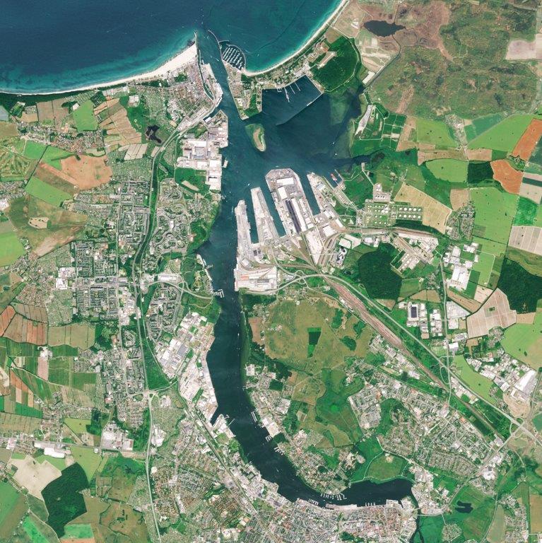
Deutschlandmosaik aus Sentinel-2-Daten (2019)
Das Mosaik ermöglicht den Bedarfsträgern aufbereitete Fernerkundungsinformationen aus dem Erdbeobachtungsprogramm Copernicus (Sentinel-2, L1C und L2A) für die Bundesrepublik Deutschland, in bestehende Fachverfahren mit einzubinden. Bilddaten des Jahres 2019 werden zu einem Mosaik zusammengefügt, welches eine Bodenauflösung von 10m hat.
Drei Komposite aus fünf Bändern (Sentinel-2 Bänder: 2, 3, 4, 5 und 8 (R, G, B, Red Edge und NIR)) sowie ein Übersichtslayer zu den Eingangsbilddaten werden angeboten.
Das Produkt Deutschlandmosaik steht momentan als WMS-Dienst zur Verfügung.
Verwendungsmöglichkeiten für das Mosaik sind: Visualisierungen für eigene Dienste und kartographische Anwendungen, Kartierungs- und Aktualisierungsunterstützung von Landbedeckungen, 3D-Flugsimulationen in Verbindung mit Höheninformationen (DGM, DOM).
|
|
Citation proposal
. Deutschlandmosaik aus Sentinel-2-Daten (2019). https://gdk.gdi-de.org/geonetwork/srv/api/records/7E882E3B-1C3A-4E7D-806D-070A02EEE96D |
INSPIRE
Identification
- File identifier
- 7E882E3B-1C3A-4E7D-806D-070A02EEE96D XML
- Hierarchy level
- dataset Dataset
Online resource
Resource identifier
- Metadata language
- German
Encoding
- Format
- TIFF
Projection
Classification of data and services
- Topic category
-
- Geoscientific information
- Imagery base maps earth cover
- Environment
- Farming
- Planning cadastre
- Economy
Classification of data and services
Coupled resource
Coupled resource
Classification of data and services
Coupled resource
Coupled resource
Keywords
- GEMET - Concepts, version 3.1 ( Theme )
Other keywords
- Keywords
-
- Satellitenbildkarte
- Copernicus
- Sentinel
- Deutschland
- Multispektral
- BKG
- Keywords
-
- opendata
Geographic coverage
))
Temporal reference
Temporal extent
Temporal extent
- Date ( Creation )
- 2020-02-20T00:00:00.000+01:00
Quality and validity
- Lineage
- Die Bilddaten wurden einem radiometrischen Farbausgleichsverfahren unterzogen um ein einheitliches Erscheinungsbild zu erlangen. Die ursprüngliche Auflösung des Kanals 5 wurde über ein Resampling-Verfahren von 20m auf 10m berechnet. Die Wolkenbedeckung für das Mosaik beträgt über das gesamte Bundesgebiet weniger als 3%.
- Distance
- 10 meter
Conformity
Conformity
Conformity
Conformity
Conformity
Conformity
Restrictions on access and use
- Access constraints
- Die Daten sind urheberrechtlich geschützt. Die Daten werden geldleistungsfrei unter folgenden Nutzungsbedingungen zur Verfügung gestellt: Rechtlicher Hinweis zur Verwendung von Copernicus Sentinel-Daten und Diensteinformationen (https://sgx.geodatenzentrum.de/web_public/gdz/lizenz/deu/Sentinel_Data_Legal_Notice_deu.pdf). Der Quellenvermerk ist zu beachten.
- Access constraints
- Quellenvermerk: Europäische Union, enthält veränderte Copernicus Sentinel-Daten (aktuelles Jahr)
- Access constraints
- {"id":"other-open","name":"Legal Notice Sentinel Data","url":"https://sg.geodatenzentrum.de/web_public/Sentinel_Data_Legal_Notice_deu.pdf","quelle":"Europäische Union, enthält veränderte Copernicus Sentinel-Daten (aktuelles Jahr)"}
Restrictions on access and use
Responsible organization (s)
Contact for the resource
- Organisation name
- Bundesamt für Kartographie und Geodäsie (BKG)
- dlz@bkg.bund.de
- Organisation name
- Bundesamt für Kartographie und Geodäsie (BKG)
- mailbox@bkg.bund.de
- Organisation name
- Bundesamt für Kartographie und Geodäsie (BKG)
- dlz@bkg.bund.de
Metadata information
Contact for the metadata
- Organisation name
- Bundesamt für Kartographie und Geodäsie (BKG)
- dlz@bkg.bund.de
- Date stamp
- 2025-03-10
- Metadata language
- German
- Character set
- UTF8
SDS
Conformance class 1: invocable
Access Point URL
Endpoint URL
Technical specification
Conformance class 2: interoperable
Coordinate reference system
Quality of Service
Access constraints
Limitation
Use constraints
Limitation
Responsible custodian
Contact for the resource
Conformance class 3: harmonized
Overviews
Provided by
