 www.geodatenkatalog.de (S2L)
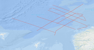
Processed seismic data of Cruise BGR79/1 1979
During cruise BGR79 from 29th June to 3rd September 1979 the Federal Institute for Geosciences and Natural Resources (BGR) carried out marine seismic reflection surveys in the three separate areas of the North Atlantic Ocean (Norwegian Sea, Scotian Basin, and U.S. East Coast Area) with S.V. EXPLORA. Simultaneously gravity, magnetic and reflection seismic data were recorded on parts of the lines. In addition, 66 sono-buoys were deployed for seismic refraction data recording on various seismic lines in all three areas. A detailed survey in the Norwegian Sea took place in the time from 29th June to 15th July, 1979 between the southern Vøring Plateau, the Jan Mayen Fracture Zone, the Møre Basin and the Faeroe-Shetland escarpment during leg 1 of cruise BGR79. The data showed that the Møre Basin contains a small sub-basin in the western part, the West-Shetland Basin. Further seaward, an outer high as well as a zone of intrusions were imaged.
|
|
Citation proposal
. Processed seismic data of Cruise BGR79/1 1979. https://gdk.gdi-de.org/geonetwork/srv/api/records/7cadffee-8e48-4326-b4f0-528bf18795f5 |
INSPIRE
Identification
- File identifier
- 7cadffee-8e48-4326-b4f0-528bf18795f5 XML
- Hierarchy level
- Dataset
Online resource
Resource identifier
- code
- 45b3ba51-ed95-dbfd-6d95-514db04a3a26
- Metadata language
- English
- Spatial representation type
- Vector
Encoding
- Format
- Shapefile
- Version
- n/a
Projection
Classification of data and services
- Topic category
-
- Geoscientific information
Classification of data and services
Coupled resource
Coupled resource
Classification of data and services
Coupled resource
Coupled resource
Keywords
- GEMET - INSPIRE themes, version 1.0 ( Theme )
-
- Geologie
- geology
- GEMET - Concepts, version 2.4 ( Theme )
-
- geophysics
- Geophysik
- raw material
- Rohstoff
Other keywords
- Keywords ( Theme )
-
- Marine geology
- Meeresgeologie
- Seismics
- Seismik
- Two-dimensional seismic reflection
- zweidimensionale Reflektionsseismik
- Keywords ( Place )
-
- Norwegische See
- Norwegian Sea
- Vøring Plateau
- Jan Mayen Bruchzone
- Møre Basin
- Faeroe-Shetland escarpment
- Jan Mayen fracture zone
- Møre Becken
Geographic coverage
N
S
E
W
))
Temporal reference
Temporal extent
Temporal extent
- Date ( Creation )
- 1979-07-15
Quality and validity
- Lineage
- During the period from the 29th June 1979 to the 15th July 1979 BGR acquired seismic lines in the Norwegian Sea. The lines BGR79-1 to BGR79-8 consist of raw data.
Conformity
Conformity
Conformity
Conformity
Conformity
Conformity
- Explanation
- siehe dazu die angegebene Durchführungsbestimmung
Restrictions on access and use
- Access constraints
- Allgemeine Geschäftsbedingungen, siehe http://www.bgr.bund.de/AGB - General terms and conditions, see http://www.bgr.bund.de/AGB_en. Die bereitgestellten Informationen sind bei Weiterverwendung wie folgt zu zitieren: Datenquelle: BGR79/1 1979, (c) BGR, Hannover, 2018
Restrictions on access and use
Responsible organization (s)
Contact for the resource
- Organisation name
- Federal Institute for Geosciences and Natural Resources
- Marine_Seismik@bgr.de
Responsible organization (s)
Contact for the resource
- Organisation name
- Federal Institute for Geosciences and Natural Resources
- Marine_Seismik@bgr.de
Metadata information
Contact for the metadata
- Organisation name
- Bundesanstalt für Geowissenschaften und Rohstoffe (BGR)
- Date stamp
- 2023-11-14
- Metadata language
- English
- Character set
- UTF8
SDS
Conformance class 1: invocable
Access Point URL
Endpoint URL
Technical specification
Conformance class 2: interoperable
Coordinate reference system
Quality of Service
Access constraints
Limitation
Use constraints
Limitation
Responsible custodian
Contact for the resource
Conformance class 3: harmonized
Overviews
Provided by

Views
7cadffee-8e48-4326-b4f0-528bf18795f5
Access to the portal
Read here the full details and access to the data.
Associated resources
Not available