 My GeoNetwork catalogue
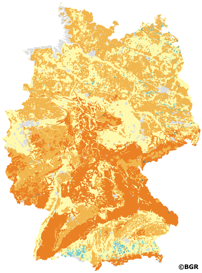
Thermal conductivity of soils in Germany 1:1,000,000
In addition to the natural soil functions, knowledge of the thermal properties of soils is an important parameter for the use of soils, e.g. for near-surface geothermal energy. The heat distribution is largely determined by how quickly the soil conducts energy in the form of heat. How strongly this happens is expressed in the property of thermal conductivity. The thermal conductivity is given in the unit W/(m*K). In addition to the material composition of soil, the water and air balance is decisive. For the present dataset, the soil profiles of the BUEK1000N were evaluated according to the soil science method documentation of the Soil Working Group AG Boden. The soil texture, the dry density and the current water content served as input data. The water content is determined indirectly by deriving the soil moisture from the field capacity and dry density. With G horizons, the total pore volume is also taken into account, with peat only the field capacity. These data are incorporated into soil type-specific equations that take into account the respective properties of sand, clay, silt and loam soils as well as those of peat soils. For solid rock, the rock-specific characteristic values of thermal conductivity are taken from tables. The parameters are determined by horizon. For each legend unit of the BUEK1000N, the dataset gives a minimum and maximum value, the median and a weighted mean value of the thermal conductivity depending on the thickness of the horizons. Settlements, open-cast mining and mudflat areas as well as the areas of landfills, wetlands and bodies of water are not assessed.
- Identification
- Distribution
- Quality
- Spatial rep.
- Ref. system
- Content
- Portrayal
- Metadata
- Md. constraints
- Md. maintenance
- Schema info
Identification
Data identification
Citation
- Alternate title
-
ThLF1000
- Date (Publication)
- 2020-11-04
- Edition
-
Version 1.0
- Citation identifier
- 1fc45c40-1e88-11eb-8732-10e7c63313a0
- Status
- Completed
-
GEMET - INSPIRE themes, Version 1.0
-
-
Soil
-
Boden
-
-
GEMET - Concepts Version 4.1.4
-
-
Boden
-
Bodenart
-
Bodenfeuchtigkeit
-
Bodenfunktion
-
Bodenkarte
-
Bodenluft
-
Bodennutzung
-
Bodenprofil
-
Bodenwasser
-
Bodenwasserhaushalt
-
Gestein
-
-
SGD-Liste
-
-
Bodeneigenschaften
-
Bodenhorizont
-
bodenphysikalische Eigenschaften
-
Festgestein
-
-
Freies Schlagwort
-
-
BÜK10000N
-
Fachinformationssystem
-
Geothermie
-
thermische Leitfähigkeit
-
Legal constraints
- Access constraints
- Other restrictions
- Other constraints
- Es gelten keine Zugriffsbeschränkungen
Legal constraints
- Use constraints
- Other restrictions
- Other constraints
-
Allgemeine Geschäftsbedingungen, siehe https://www.bgr.bund.de/AGB - General terms and conditions, see https://www.bgr.bund.de/AGB_en . Die bereitgestellten Informationen sind bei Weiterverwendung wie folgt zu zitieren: Datenquelle: ThLF1000 V1.0, (c) BGR, Hannover, 2020
- Denominator
- 1000000
- Language
- Deutsch
- Character set
- UTF8
- Topic category
-
- Geoscientific information
))
- Geographic identifier
- Regionalschlüssel / 000000000000
Distribution
Distribution
- Distribution format
-
-
PDF
(
n/a
)
-
Shapefile
(
n/a
)
-
JPEG
(
n/a
)
-
PNG
(
n/a
)
-
TIFF
(
n/a
)
-
PDF
(
n/a
)
Digital transfer options
- Transfer size
- 43
- OnLine resource
-
ThLF1000 (PDF)
ThLF1000 im Format Adobe Acrobat (Auflösung 600 dpi)
Digital transfer options
- Transfer size
- 18
- OnLine resource
-
ThLF1000 (Shapefile)
ThLF1000 im Format ESRI Shape
Digital transfer options
- Transfer size
- 48
- OnLine resource
-
ThLF1000 (JPEG)
ThLF1000 im Format JPEG (Auflösung 300 dpi)
Digital transfer options
- Transfer size
- 17
- OnLine resource
-
ThLF1000 (PNG)
ThLF1000 im Format PNG (Auflösung 300 dpi)
Digital transfer options
- Transfer size
- 42
- OnLine resource
-
ThLF1000 (TIFF)
ThLF1000 im Format TIFF (Auflösung 300 dpi)
Quality
Data quality
Scope
- Hierarchy level
- Dataset
Conformance result
Citation
- Date (Publication)
- 2010-12-08
- Explanation
-
siehe dazu die angegebene Durchführungsbestimmung
- Statement
-
Nutzungsdifferenzierte Bodenübersichtskarte der Bundesrepublik Deutschland 1:1.000.000 (BÜK1000N).
Ref. system
- Unique resource identifier
- EPSG:3035
Metadata
Metadata
- File identifier
- 7cfc3ccb-3791-478c-bd07-5ace4493f939 XML
- Metadata language
- Deutsch
- Character set
- UTF8
- Hierarchy level
- Dataset
- Hierarchy level name
-
Boden
- Date stamp
- 2025-04-07
- Metadata standard name
-
INSPIRE Metadata Implementing Rules: Technical Guidelines based on EN ISO 19115 and EN ISO 19119
- Metadata standard version
-
n/a
Overviews
Spatial extent
Provided by
