 My GeoNetwork catalogue
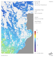
AVHRR - Sea Surface Temperature (SST) - Europe
The AVHRR Mulitchannel Sea Surface Temperature Map (MCSST) was the first result of DLR's AVHRR pathfinder activities. The goal of the product is to provide the user with actual Sea Surface Temperature (SST) maps in a defined format easy to access with the highest possible reliability on the thematic quality. After a phase of definition, the operational production chain was launched in March 1993 covering the entire Mediterranean Sea and the Black Sea. Since then, daily, weekly, and monthly data sets have been available until September 13, 1994, when the AVHRR on board the NOAA-11 spacecraft failed. The production of daily, weekly and monthly SST maps was resumed in February, 1995, based on NOAA-14 AVHRR data. The NOAA-14 AVHRR sensor became some technical difficulties, so the generation was stopped on October 3, 2001. Since March 2002, NOAA-16 AVHRR SST maps are available again. With the beginning of January 2004, the data of AVHRR on board of NOAA-16 exhibited some anormal features showing strips in the scenes. Facing the “bar coded” images of NOAA16-AVHRR which occurred first in September 2003, continued in January 2004 for the second time and appeared in April 2004 again, DFD has decided to stop the reception of NOAA16 data on April 6th, 2004, and to start the reception of NOAA-17 data on this day. On April 7th, 2004, the production of all former NOAA16-AVHRR products as e.g. the SST composites was successully established. NOAA-17 is an AM sensor which passes central Europe about 2 hours earlier than NOAA-16 (about 10:00 UTC instead of 12:00 UTC for NOAA-16). In spring 2007, the communication system of NOAA-17 has degraded or is operating with limitations. Therefore, DFD has decided to shift the production of higher level products (NDVI, LST and SST) from NOAA-17 to NOAA-18 in April 2007. In order to test the performance of our processing chains, we processed simultaneously all NOAA-17 and NOAA-18 data from January 1st, 2007 till March 29th, 2007. All products are be available via EOWEB. Please remember that NOAA-18 is a PM sensor which passes central Europe about 1.5 hours later than NOAA-17 (about 11:30 UTC instead of 10:00 UTC for NOAA17). The SST product is intended for climate modelers, oceanographers, and all geo science-related disciplines dealing with ocean surface parameters. In addition, SST maps covering the North Atlantic, the Baltic Sea, the North Sea and the Western Atlantic equivalent to the Mediterranean MCSST maps are available since August 1994. The most important aspects of the MCSST maps are a) correct image registration and b) reasonable cloud screening to ensure that only cloud free pixels are taken for the later processing and compositing c) for deriving MCSST, only channel 4 and 5 are used.. The SST product consists of one 8 bit channel. For additional information, please see: https://wdc.dlr.de/sensors/avhrr/
INSPIRE
Identification
- File identifier
- 802569b8-fb56-4d78-a2e8-3e4549ff475b XML
- Hierarchy level
- Series
Online resource
- Protocol
-
WWW:LINK-1.0-http--link
- Protocol
-
OGC:WMS
Resource identifier
- Metadata language
- English
Encoding
Projection
Classification of data and services
- Topic category
-
- Oceans
Classification of data and services
Coupled resource
Coupled resource
Classification of data and services
Coupled resource
Coupled resource
Keywords
-
GEMET - INSPIRE themes, version 1.0
-
-
Oceanographic geographical features
-
Other keywords
- Keywords
-
-
AVHRR
-
NOAA-11
-
NOAA-14
-
NOAA-16
-
NOAA-17
-
NOAA-18
-
NOAA-19
-
Sea Surface Temperature
-
Europe
-
urn:eop:DLR:EOWEB:NOAA.AVHRR.SST
-
FEDEO
-
Geographic coverage
))
))
))
Temporal reference
Temporal extent
- Begin
- 1994-08-01
Temporal extent
- Date (Creation)
- 2011-01-29T00:00:00
Quality and validity
- Lineage
-
The SST product is derived from NOAA AVHRR data received at DLR. The processing steps are outlined below: 1. Automatic pre-navigation / interactive supervision 2. Calibration of thermal channels of NOAA-11, NOAA-14, NOAA-16, NOAA-17 and NOAA-18 AVHRR 3. Cloud Screening and Clearing 4. Derivation of the Multi Channel Sea Surface Temperature (MCSST) 5. Remapping 6. Compositing / synthesis 7. Ocean masking 8. Integer-scaling.
Conformity
Conformity
Conformity
Conformity
Conformity
Conformity
- Explanation
-
See the referenced specification
Restrictions on access and use
- Access constraints
-
License: https://geoservice.dlr.de/resources/licenses/D-SDA_DataLicenseTerms.pdf
Responsible organization (s)
Contact for the resource
- Organisation name
-
German Aerospace Center (DLR)
Responsible organization (s)
Contact for the resource
- Organisation name
-
German Aerospace Center (DLR)
Metadata information
Contact for the metadata
- Organisation name
-
German Aerospace Center (DLR)
- Date stamp
- 2024-09-27T12:48:48
- Metadata language
- English
SDS
Conformance class 1: invocable
Access Point URL
Endpoint URL
Technical specification
Conformance class 2: interoperable
Access constraints
Limitation
Use constraints
Limitation
Responsible custodian
Contact for the resource
Overviews

Spatial extent
Provided by
