 My GeoNetwork catalogue
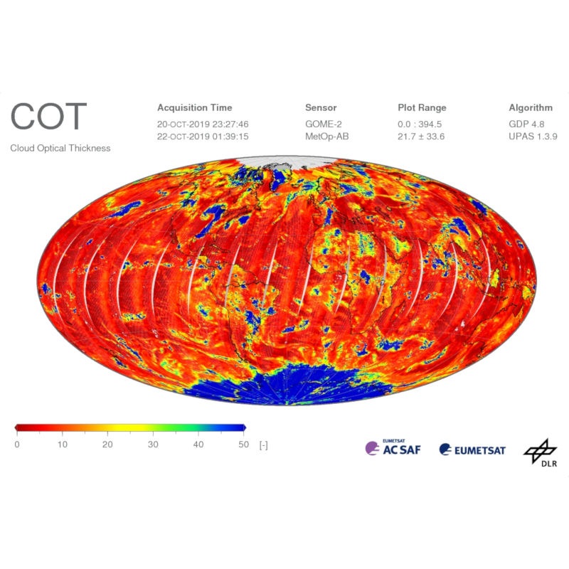
METOP GOME-2 - Cloud Optical Thickness (COT) - Global
The Global Ozone Monitoring Experiment-2 (GOME-2) instrument continues the long-term monitoring of atmospheric trace gas constituents started with GOME / ERS-2 and SCIAMACHY / Envisat. Currently, there are three GOME-2 instruments operating on board EUMETSAT's Meteorological Operational satellites MetOp-A, -B and -C, launched in October 2006, September 2012, and November 2018, respectively. GOME-2 can measure a range of atmospheric trace constituents, with the emphasis on global ozone distributions. Furthermore, cloud properties and intensities of ultraviolet radiation are retrieved. These data are crucial for monitoring the atmospheric composition and the detection of pollutants. DLR generates operational GOME-2 / MetOp level 2 products in the framework of EUMETSAT's Satellite Application Facility on Atmospheric Chemistry Monitoring (AC-SAF). GOME-2 near-real-time products are available already two hours after sensing.
OCRA (Optical Cloud Recognition Algorithm) and ROCINN (Retrieval of Cloud Information using Neural Networks) are used for retrieving the following geophysical cloud properties from GOME and GOME-2 data: cloud fraction (cloud cover), cloud-top pressure (cloud-top height), and cloud optical thickness (cloud-top albedo). OCRA is an optical sensor cloud detection algorithm that uses the PMD devices on GOME / GOME-2 to deliver cloud fractions for GOME / GOME-2 scenes. ROCINN takes the OCRA cloud fraction as input and uses a neural network training scheme to invert GOME / GOME-2 reflectivities in and around the O2-A band. VLIDORT [Spurr (2006)] templates of reflectances based on full polarization scattering of light are used to train the neural network. ROCINN retrieves cloud-top pressure and cloud-top albedo. The cloud optical thickness is computed using libRadtran [Mayer and Kylling (2005)] radiative transfer simulations taking as input the cloud-top albedo retrieved with ROCINN. For more details please refer to relevant peer-review papers listed on the GOME and GOME-2 documentation pages: https://atmos.eoc.dlr.de/app/docs/
INSPIRE
Identification
- File identifier
- 810631f4-c311-44f2-9ced-c2260df2bc06 XML
- Hierarchy level
- Series
Online resource
- Protocol
-
WWW:LINK-1.0-http--link
- Protocol
-
WWW:DOWNLOAD-1.0-ftp--download
- Protocol
-
WWW:LINK-1.0-http--link
- Protocol
-
OGC:WMS
- Protocol
-
OGC:WMS
- Protocol
-
OGC:WMS
- Protocol
-
OGC:WCS
- Protocol
-
OGC:WCS
- Protocol
-
OGC:WCS
- Protocol
-
OGC:WMS-http-get-capabilities
- Protocol
-
OGC:WCS-http-get-capabilities
Resource identifier
- Metadata language
- English
- Spatial representation type
- Grid
Encoding
Projection
- code
-
WGS 84 (EPSG:4326)
Classification of data and services
- Topic category
-
- Climatology, meteorology, atmosphere
Classification of data and services
Coupled resource
Coupled resource
Classification of data and services
Coupled resource
Coupled resource
Keywords
-
GEMET - INSPIRE themes, version 1.0
-
-
Atmospheric conditions
-
Other keywords
- Keywords
-
-
MetOp-A
-
MetOp-B
-
MetOp-C
-
GOME-2
-
COT
-
Cloud Optical Thickness
-
AC-SAF
-
GOME.TC.AGG
-
urn:eop:DLR:EOWEB:GOME.TC.AGG
-
FEDEO
-
Geographic coverage
))
Temporal reference
Temporal extent
- Begin
- 2007-01-23T10:16:34
Temporal extent
- Date (Creation)
- 2020-02-22T00:00:00
Quality and validity
- Lineage
-
Please refer to relevant peer-review papers listed on the GOME and GOME-2 documentation pages for more details on cloud optical thickness retrieval: https://atmos.eoc.dlr.de/app/docs/
- Denominator
- 80000000
Conformity
Conformity
Conformity
Conformity
Conformity
Conformity
- Explanation
-
See the referenced specification
Restrictions on access and use
- Access constraints
-
License
- Access constraints
-
Nutzungsbedingungen: Lizenz, https://geoservice.dlr.de/resources/licenses/ac_saf/AC-SAF_User_License.pdf / Terms of use: License, https://geoservice.dlr.de/resources/licenses/ac_saf/AC-SAF_User_License.pdf
Responsible organization (s)
Contact for the resource
- Organisation name
-
German Aerospace Center (DLR)
- Organisation name
-
German Aerospace Center (DLR)
Responsible organization (s)
Contact for the resource
- Organisation name
-
German Aerospace Center (DLR)
- Organisation name
-
German Aerospace Center (DLR)
Metadata information
Contact for the metadata
- Organisation name
-
German Aerospace Center (DLR)
- Date stamp
- 2024-09-27T13:33:30
- Metadata language
- English
- Character set
- UTF8
SDS
Conformance class 1: invocable
Access Point URL
Endpoint URL
Technical specification
Conformance class 2: interoperable
Access constraints
Limitation
Use constraints
Limitation
Responsible custodian
Contact for the resource
Overviews
Spatial extent
Provided by
