 www.geodatenkatalog.de (S1L)
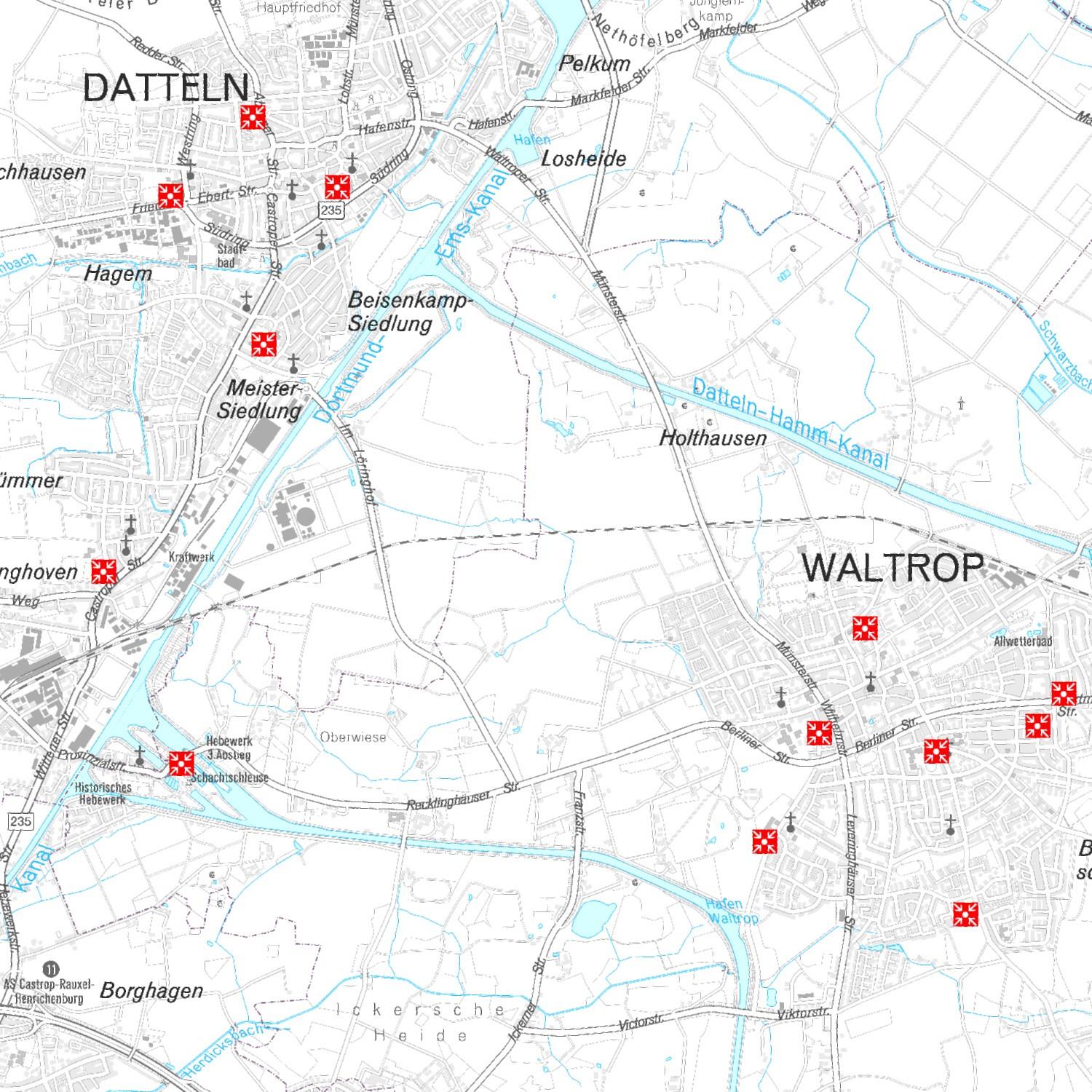
Notfallinfopunkte (Kreis Recklinghausen / Vektordaten)
|
|
Citation proposal
(2019) . Notfallinfopunkte (Kreis Recklinghausen / Vektordaten). https://gdk.gdi-de.org/geonetwork/srv/api/records/817f9442-26bb-4986-be4a-d42369f41fae |
INSPIRE
Identification
- File identifier
- 817f9442-26bb-4986-be4a-d42369f41fae XML
- Hierarchy level
- Dataset
Online resource
- Protocol
- WWW:LINK-1.0-http--link
- Protocol
- OGC:WMS-1.3.0-http-get-map
- Protocol
- WWW:LINK-1.0-http--link
- Protocol
- OGC:WFS
- Protocol
- WWW:LINK-1.0-http--link
Resource identifier
- Metadata language
- German
- Spatial representation type
- Vector
Encoding
Projection
- code
- EPSG 25832
Classification of data and services
- Topic category
-
- Planning cadastre
Classification of data and services
Coupled resource
Coupled resource
Classification of data and services
Coupled resource
Coupled resource
Keywords
- GEMET ( Theme )
-
- Katastrophenschutz
- Katastrophenhilfe
- Katastrophe
- GovData ( Theme )
-
- Geographie, Geologie und Geobasisdaten
- Bevölkerung
- Region ( Place )
-
- Kreis Recklinghausen
Other keywords
- Keywords ( Theme )
-
- Bevölkerungsschutz
Geographic coverage
))
Temporal reference
Temporal extent
Temporal extent
- Date ( Publication )
- 2019-03-07T08:00:00
- Date ( Creation )
- 2019-03-26
Quality and validity
- Lineage
Conformity
Conformity
Conformity
Conformity
Conformity
Conformity
Restrictions on access and use
- Access constraints
-
Nutzungsbedingungen: Der Layer Notfallinfopunkte wird unter der „Creative Commons Namensnennung- Keine Bearbeitung 4.0 International Lizenz“ siehe https://creativecommons.org/licenses/by-nd/4.0/legalcode.de zur Verfügung gestellt.Namensnennung: Kreisverwaltung Recklinghausen © Kreis Recklinghausen
Lizenz: Creative Commons Namensnennung- Keine Bearbeitung 4.0 International Lizenz (CC BY-ND 4.0)
Eine Gewähr über die Aktualität, Richtigkeit und Vollständigkeit der Daten und Schilder vor Ort kann nicht übernommen werden.
Bitte melden Sie Mängel oder Unregelmäßigkeiten an Herrn Gurk vom FD 38 (Bevölkerungsschutz und Kreisleitstelle)
- Access constraints
- {"id":"cc-by-nd/4.0","name":"Creative Commons Namensnennung (CC BY-ND 4.0)","url":"https://creativecommons.org/licenses/by-nd/4.0/","quelle":"©Kreis Recklinghausen (Jahr)"}
Restrictions on access and use
Responsible organization (s)
Contact for the resource
- Organisation name
- Kreisverwaltung Recklinghausen
- Organisation name
- Kreisverwaltung Recklinghausen
Responsible organization (s)
Contact for the resource
- Organisation name
- Kreisverwaltung Recklinghausen
- Organisation name
- Kreisverwaltung Recklinghausen
Metadata information
Contact for the metadata
- Organisation name
- Kreisverwaltung Recklinghausen
- Date stamp
- 2025-07-17T05:06:14.866Z
- Metadata language
- German
- Character set
- UTF8
SDS
Conformance class 1: invocable
Access Point URL
Endpoint URL
Technical specification
Conformance class 2: interoperable
Coordinate reference system
Quality of Service
Access constraints
Limitation
Use constraints
Limitation
Responsible custodian
Contact for the resource
Conformance class 3: harmonized
Overviews
Provided by
