 www.geodatenkatalog.de (S1L)
Global SnowPack - MODIS - Yearly
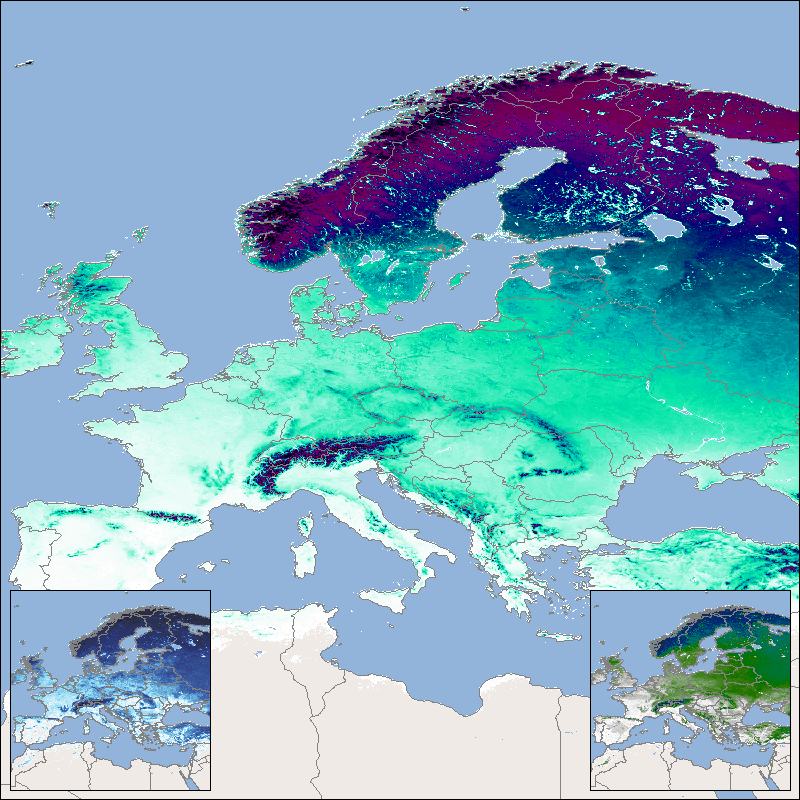
This product shows the snow cover duration for a hydrological year. Its beginning differs from the calendar year, since some of the precipitation that falls in late autumn and winter falls as snow and only drains away when the snow melts in the following spring or summer. The meteorological seasons are used for subdivision and the hydrological year begins in autumn and ends in summer. The snow cover duration is made available for three time periods: the snow cover duration for the entire hydrological year (SCD), the early snow cover duration (SCDE), which extends from autumn to midwinter (), and the late snow cover duration (SCDL), which in turn extends over the period from mid-winter to the end of summer. For the northern hemisphere SCD lasts from September 1st to August 31st, for the southern hemisphere it lasts from March 1st to February 28th/29th. The SCDE lasts from September 1st to January 14th in the northern hemisphere and from March 1st to July 14th in the southern hemisphere. The SCDL lasts from January 15th to August 31st in the northern hemisphere and from July 15th to February 28th/29th in the southern hemisphere.
The “Global SnowPack” is derived from daily, operational MODIS snow cover product for each day since February 2000. Data gaps due to polar night and cloud cover are filled in several processing steps, which provides a unique global data set characterized by its high accuracy, spatial resolution of 500 meters and continuous future expansion. It consists of the two main elements daily snow cover extent (SCE) and seasonal snow cover duration (SCD; full and for early and late season). Both parameters have been designated by the WMO as essential climate variables, the accurate determination of which is important in order to be able to record the effects of climate change. Changes in the largest part of the cryosphere in terms of area have drastic effects on people and the environment.
For more information please also refer to:
Dietz, A.J., Kuenzer, C., Conrad, C., 2013. Snow-cover variability in central Asia between 2000 and 2011 derived from improved MODIS daily snow-cover products. International Journal of Remote Sensing 34, 3879–3902. https://doi.org/10.1080/01431161.2013.767480
Dietz, A.J., Kuenzer, C., Dech, S., 2015. Global SnowPack: a new set of snow cover parameters for studying status and dynamics of the planetary snow cover extent. Remote Sensing Letters 6, 844–853. https://doi.org/10.1080/2150704X.2015.1084551
Dietz, A.J., Wohner, C., Kuenzer, C., 2012. European Snow Cover Characteristics between 2000 and 2011 Derived from Improved MODIS Daily Snow Cover Products. Remote Sensing 4. https://doi.org/10.3390/rs4082432
Dietz, J.A., Conrad, C., Kuenzer, C., Gesell, G., Dech, S., 2014. Identifying Changing Snow Cover Characteristics in Central Asia between 1986 and 2014 from Remote Sensing Data. Remote Sensing 6. https://doi.org/10.3390/rs61212752
Rößler, S., Witt, M.S., Ikonen, J., Brown, I.A., Dietz, A.J., 2021. Remote Sensing of Snow Cover Variability and Its Influence on the Runoff of Sápmi’s Rivers. Geosciences 11, 130. https://doi.org/10.3390/geosciences11030130
|
|
Citation proposal
. Global SnowPack - MODIS - Yearly. https://gdk.gdi-de.org/geonetwork/srv/api/records/820296dc-11c9-4214-84bf-4871a01fc926 |
INSPIRE
Identification
- File identifier
- 820296dc-11c9-4214-84bf-4871a01fc926 XML
- Hierarchy level
- Series
Online resource
- Protocol
- OGC:WMS
- Protocol
- OGC:WMS
- Protocol
- OGC:WMS
- Protocol
- OGC:WMS-http-get-capabilities
- Protocol
- WWW:LINK-1.0-http--link
- Protocol
- WWW:LINK-1.0-http--link
- Protocol
- WWW:LINK-1.0-http--link
Resource identifier
- Metadata language
- English
- Spatial representation type
- Grid
Encoding
- Format
- GeoTIFF
Projection
Classification of data and services
- Topic category
-
- Climatology, meteorology, atmosphere
Classification of data and services
Coupled resource
Coupled resource
Classification of data and services
Coupled resource
Coupled resource
Keywords
- GEMET - INSPIRE themes, version 1.0 ( Theme )
-
- Land cover
- Spatial scope
Other keywords
- Keywords
-
- MODIS
- Global SnowPack
- snow cover duration
- snow cover duration late season
- snow cover duration early season
- snow
- SCD
- SCDE
- SCDL
- opendata
- inspireidentifiziert
Geographic coverage
))
Temporal reference
Temporal extent
Temporal extent
- Date ( Creation )
- 2022-03-01T00:00:00
Quality and validity
- Lineage
-
Created from MODIS daily snow cover products MOD10A1, MYD10A1 provided by the National Snow and Ice Datacenter NSIDC (https://nsidc.org/)
Processing steps include combination of observations recorded by Aqua and Terra, temporal interpolation of 3 successive days, snow line identification, and a seasonal filter. More details are available in the publication "Dietz A.J., Kuenzer, C., and Dech, S. (2015): Global SnowPack: a new set of snow cover parameters for studying status and dynamics of the planetary snow cover extent; Remote Sensing Letters 6, No. 11. pp. 844-853
- Denominator
- 920000
Conformity
Conformity
Conformity
Conformity
Conformity
Conformity
- Explanation
- See the referenced specification.
Restrictions on access and use
- Access constraints
- Nutzungsbedingungen: Lizenz, https://creativecommons.org/licenses/by/4.0 / Terms of use: License, https://creativecommons.org/licenses/by/4.0
- Access constraints
-
{"id": "cc-by/4.0",
"name": "Creative Commons - Attribution 4.0 International (CC BY 4.0)",
"url": "http://dcat-ap.de/def/licenses/cc-by/4.0",
"quelle": "Copyright DLR (2022)"}
Restrictions on access and use
Responsible organization (s)
Contact for the resource
- Organisation name
- DFD-LAX
- Global-SnowPack@dlr.de
- Organisation name
- German Aerospace Center (DLR)
- geoservice@dlr.de
Responsible organization (s)
Contact for the resource
- Organisation name
- DFD-LAX
- Global-SnowPack@dlr.de
- Organisation name
- German Aerospace Center (DLR)
- geoservice@dlr.de
Metadata information
Contact for the metadata
- Organisation name
- German Aerospace Center (DLR)
- geoservice@dlr.de
- Date stamp
- 2024-06-20T13:06:58
- Metadata language
- English
- Character set
- UTF8
SDS
Conformance class 1: invocable
Access Point URL
Endpoint URL
Technical specification
Conformance class 2: interoperable
Coordinate reference system
Quality of Service
Access constraints
Limitation
Use constraints
Limitation
Responsible custodian
Contact for the resource
Conformance class 3: harmonized
Overviews
Provided by
