 www.geodatenkatalog.de (S1L)
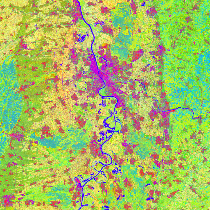
TimeScan - Landsat - 2015, Global
The TimeScan product is based on the fully-automated analysis of comprehensive time-series acquisitions of Landsat data. Based on a user-specified definition of the required period of time, the region of interest and – optionally – the maximum cloud cover, the TimeScan processor starts with the collection of all available Landsat scenes that meet the user specification. Next, for each single scene masking of clouds, haze and shadow is conducted using the Fmask algorithm. Then, a total of 6 indices is calculated for those pixels of each single scene that have not been masked in the prior step. The set of indices includes the Normalized Difference Vegetation Index (NDVI), the Built-up Index (BI), the Modified Normalized Difference Water Index (MNDWI), the Normalized Difference Band-5 / Band-7 (ND57), the Normalized Difference Band-4 / Band-3 (ND43), and the Normalized Difference Band-3 / Band-2 (ND32). Finally, the TimeScan product is generated by calculating the temporal statistics (minimum, maximum, mean, standard deviation, mean slope) for each index over the defined period of time. Hence, in case of the defined 6 indices chosen, the TimeScan product will include a total of 30 bands (5 statistical features per index). As an additional band a quality layer is added which shows for each pixel the number of valid values (meaning times with no cloud/haze or shadow cover) that have been included in the statistics calculation.
|
|
Citation proposal
German Aerospace Center (DLR) (2021) . TimeScan - Landsat - 2015, Global. https://gdk.gdi-de.org/geonetwork/srv/api/records/8329898d-35d8-4f67-ae5a-41a03fc4a70d |
- Identification
- Distribution
- Quality
- Spatial rep.
- Ref. system
- Content
- Portrayal
- Metadata
- Md. constraints
- Md. maintenance
- Schema info
Identification
Data identification
Citation
- Date ( Publication )
- 2021-05-10T09:00:00
- Edition
- Presentation form
- Digital image
- Other citation details
- Status
- Completed
Point of contact
- Maintenance and update frequency
- As needed
- GEMET - INSPIRE themes, version 1.0 ( Theme )
-
- Land cover
- Spatial scope ( Place )
- Keywords
-
- TimeScan
- Landsat
- time-series
- spectral indices
- temporal statistics
- Use limitation
- Nutzungseinschränkungen: Das DLR ist nicht haftbar für Schäden, die sich aus der Nutzung ergeben. / Use Limitations: DLR not liable for damage resulting from use.
Legal constraints
- Access constraints
- Other restrictions
Legal constraints
- Use constraints
- Other restrictions
- Other constraints
- Nutzungsbedingungen: Lizenz, https://creativecommons.org/licenses/by-nc/4.0 / Terms of use: License, https://creativecommons.org/licenses/by-nc/4.0
- Other constraints
-
{"id": "cc-by-nc-4.0",
"name": "Creative Commons Namensnennung - Nicht kommerziell 4.0 International (CC BY-NC 4.0)",
"url": "http://dcat-ap.de/def/licenses/cc-by-nc/4.0",
"quelle": "Copyright DLR (year of production)"}
- Spatial representation type
- Grid
- Denominator
- 60000
- Metadata language
- English
- Character set
- UTF8
- Topic category
-
- Imagery base maps earth cover
Extent
N
S
E
W
))
Distribution
Distribution
- Distribution format
-
- GeoTIFF ()
- OnLine resource
-
TS_LANDSAT_2015
WMS access TimeScan Landsat 2015
Quality
Data quality
- Hierarchy level
- Dataset
Domain consistency
- Measure identification
- INSPIRE / Conformity_001
Conformance result
Citation
- Date ( Publication )
- 2010-12-08
- Explanation
- See the referenced specification.
- Pass
- true
Lineage
- Statement
- The TimeScan Landsat 2015 dataset is based on data acquired by the Landsat-8 mission.
- Description
- For details see: Esch, Thomas and Marconcini, Mattia and Üreyen, Soner and Zeidler, Julian and Hirner, Andreas and Asamer, Hubert and Rogge, Derek and Metz, Annekatrin and Tum, Markus and Boettcher, Martin and Kuchař, Štěpán and Svaton, Vaclav (2017) Exploiting Big Data from Earth Observation - The TimeScan Framework. ISPRS Journal of Photogrammetry and Remote Sensing. Elsevier B.V. ISSN 0924-2716 (submitted)
Spatial rep.
Grid spatial representation
- Number of dimensions
- 2
Dimension
- Dimension name
- Column
- Dimension size
- 1333332
- Resolution
- 30 m
Dimension
- Dimension name
- Row
- Dimension size
- 666666
- Resolution
- 30 m
- Cell geometry
- Area
- Transformation parameter availability
- false
Metadata
Metadata
- File identifier
- 8329898d-35d8-4f67-ae5a-41a03fc4a70d XML
- Metadata language
- English
- Character set
- UTF8
- Hierarchy level
- Dataset
- Hierarchy level name
- Dataset
- Date stamp
- 2024-11-11T08:39:03
- Metadata standard name
- ISO19115
- Metadata standard version
- 2003/Cor.1:2006
Point of contact
Overviews
large_thumbnail
thumbnail
Provided by

Views
8329898d-35d8-4f67-ae5a-41a03fc4a70d
Access to the portal
Read here the full details and access to the data.
Associated resources
Not available