 My GeoNetwork catalogue
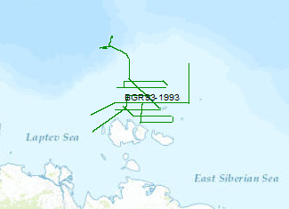
Processed seismic data of Cruise BGR 1993
In September 1993, the Federal Institute for Geoscience and Natural Resources (BGR) has carried out in cooperation with Sevmorneftegeofizika (SMNG), Murmansk a 2D-seismic survey of the eastern part of the Laptev Sea shelf. The data format is Society of Exploration Geophysicists SEG Y. During the survey with a total length of 3189 km the 70 km wide New Siberian Basin and two other basins were mapped. In the central part of the New Siberian Basin, a Tertiary sediment thickness of more than 4 km overlying older sediments was observed. Further to the east, a large area covered by lava flows of unknown thickness was investigated. There are no indications of a propagation of real seafloor spreading into the Laptev Shelf and thus the Asian continental crust. Therefore seafloor spreading seems impossible at total spreading rates below 0.7 cm/year, at least for crust of the character which is present here.
- Identification
- Distribution
- Quality
- Spatial rep.
- Ref. system
- Content
- Portrayal
- Metadata
- Md. constraints
- Md. maintenance
- Schema info
Identification
Data identification
Citation
- Alternate title
-
BGR 1993
- Date (Creation)
- 1993-09-28
- Citation identifier
- 17640541-e78a-4619-937a-d652cc22b066
- Status
- Completed
-
GEMET - INSPIRE themes, version 1.0
-
-
geology
-
Geologie
-
-
GEMET - Concepts, version 2.4
-
-
geophysics
-
Geophysik
-
raw material
-
Rohstoff
-
marine geology
-
Meeresgeologie
-
- Theme
-
-
seismics
-
Seismik
-
two-dimensional seismic reflection
-
zweidimensionale Reflektionsseismik
-
MSSP
-
- Place
-
-
Laptev Sea
-
Laptev See
-
Legal constraints
- Access constraints
- Other restrictions
- Other constraints
- Es gelten keine Zugriffsbeschränkungen
Legal constraints
- Use constraints
- Other restrictions
- Other constraints
-
Allgemeine Geschäftsbedingungen, siehe https://www.bgr.bund.de/AGB - General terms and conditions, see https://www.bgr.bund.de/AGB_en . Die bereitgestellten Informationen sind bei Weiterverwendung wie folgt zu zitieren: Datenquelle: BGR93, (c) BGR, Hannover, 1993
- Spatial representation type
- Vector
- Language
- English
- Character set
- UTF8
- Topic category
-
- Geoscientific information
))
Distribution
Distribution
- Distribution format
-
-
Shapefile
(
n/a
)
-
Shapefile
(
n/a
)
Digital transfer options
- Transfer size
- 1
- OnLine resource
-
BGR 1993 (Shapefile)
BGR 1993 im Format ESRI Shape
- OnLine resource
- Profil BGR93-02
- OnLine resource
- Profil BGR93-03
- OnLine resource
- Profil BGR93-04
- OnLine resource
- Profil BGR93-05
- OnLine resource
- Profil BGR93-06
- OnLine resource
- Profil BGR93-07
- OnLine resource
- Profil BGR93-08
- OnLine resource
- Profil BGR93-09
- OnLine resource
- Profil BGR93-10
- OnLine resource
- Profil BGR93-11
- OnLine resource
- Profil BGR93-12
- OnLine resource
- Profil BGR93-13
- OnLine resource
- Profil BGR93-14
- OnLine resource
- Profil BGR93-15
- OnLine resource
- Profil BGR93-16
- OnLine resource
- Profil BGR93-17
- OnLine resource
- Profil BGR93-18
- OnLine resource
- Profil BGR93-19
- OnLine resource
- Profil BGR93-20
- OnLine resource
- Profil BGR93-21
- OnLine resource
- Profil BGR93-22
- OnLine resource
- Profil BGR93-23
- OnLine resource
- Profil BGR93-24
- OnLine resource
- Profil BGR93-25
- OnLine resource
- Karte im BGR-Geoviewer
Quality
Data quality
Scope
- Hierarchy level
- Dataset
Conformance result
Citation
- Date (Publication)
- 2010-12-08
- Explanation
-
siehe dazu die angegebene Durchführungsbestimmung
- Statement
-
During the period of 5th of September to 28th of September 1993 BGR aquired seismic lines in the Laptev Sea. The lines BGR93-02, BGR93-03, BGR93-04, BGR93-06, BGR93-07, BGR93-09, BGR93-10, BGR93-12, BGR93-15, BGR93-17, BGR93-18, BGR93-20, BGR93-21, BGR93-23 are processed (migrated) data and the lines BGR93-05, BGR93-08, BGR93-11, BGR93-13, BGR93-14 are processed (stack) data. The lines BGR93-16, BGR93-19, BGR93-22, BGR93-24, BGR93-25 are raw data.
Ref. system
- Unique resource identifier
- EPSG:4326
Metadata
Metadata
- File identifier
- 83f10c52-ff53-4b84-9fdd-0fa2e41d5f08 XML
- Metadata language
- English
- Character set
- UTF8
- Parent identifier
-
Marine Seismic Survey Profiles (MSSP)
06a73c56-06a2-40d8-b806-466222b0760d
- Hierarchy level
- Dataset
- Hierarchy level name
-
Geophysik
- Date stamp
- 2025-04-07
- Metadata standard name
-
INSPIRE Metadata Implementing Rules: Technical Guidelines based on EN ISO 19115 and EN ISO 19119
- Metadata standard version
-
n/a
Overviews
Spatial extent
Provided by
