 www.geodatenkatalog.de (S3L)
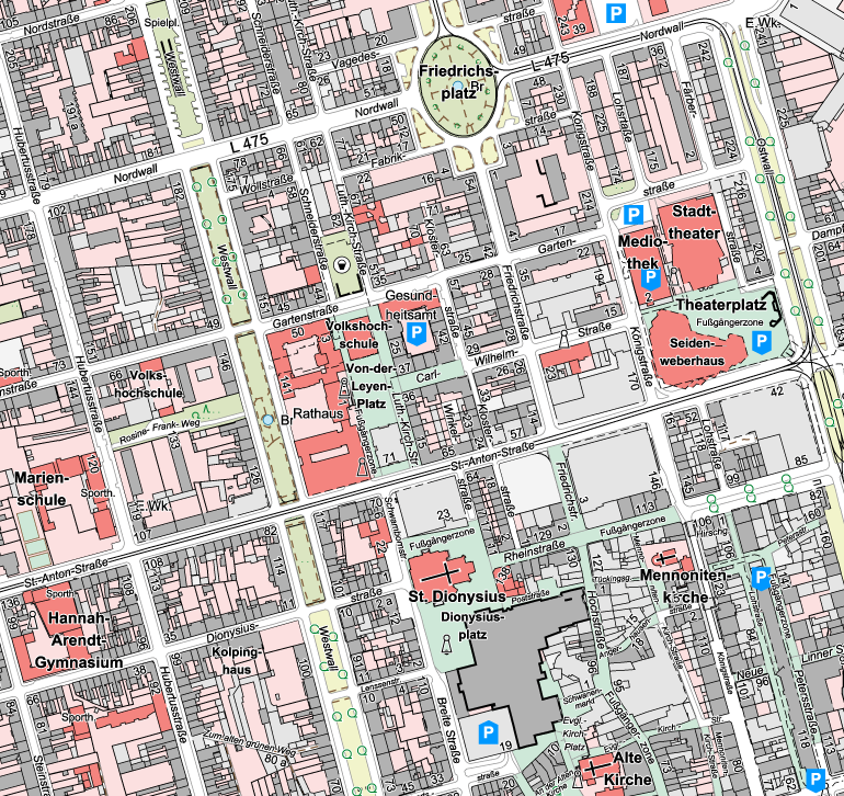
Amtliche Basiskarte Krefeld
Die Amtliche Basiskarte (ABK) stellt die wesentlichen Inhalte des Liegenschaftskataster wie Flurstücke, Gebäude, tatsächliche Nutzung und Topographie einschließlich der zugehörigen Beschriftungen und Symbole dar. Die ABK stellt die Verbindung zwischen der eigentumsorientierten Liegenschaftskarte und den topographischen Kartenwerken her und ist der Nachfolger der Deutschen Grundkarte (DGK). Die Darstellung orientiert sich an dem ALKIS-Signaturenkatalog NRW. Die ABK Krefeld ist in den Maßstäben 1:2.500, 1:5.000 und 1:10.000 verfügbar.
|
|
Citation proposal
(2024) . Amtliche Basiskarte Krefeld. Stadt Krefeld https://gdk.gdi-de.org/geonetwork/srv/api/records/83f66233-516d-42b2-b0d6-a47b37892e7e |
INSPIRE
Identification
- File identifier
- 83f66233-516d-42b2-b0d6-a47b37892e7e XML
- Hierarchy level
- dataset Dataset
Online resource
Resource identifier
- Metadata language
- German
Encoding
Projection
Classification of data and services
- Topic category
-
- Planning cadastre
- Structure
- Boundaries
- Imagery base maps earth cover
- Location
Classification of data and services
Coupled resource
Coupled resource
Classification of data and services
Coupled resource
Coupled resource
Keywords
Other keywords
- Keywords
-
- ALKIS
- Grenze
- Gebäude
- Bauwerk
- Topografie
- Kataster
- Liegenschaftskataster
- Stadt Krefeld
- Nordrhein-Westfalen
- Krefeld
- Geobasisdaten
- ABK
- Amtliche Basiskarte
- Basiskarte
- DGK
- Grundkarte
- tatsächliche Nutzung
- Nutzungsart
- opendata
- Keywords ( Theme )
-
- REGI
- ENVI
Geographic coverage
N
S
E
W
))
Temporal reference
Temporal extent
Temporal extent
- Date ( Publication )
- 2024-10-23T00:00:00.000+02:00
Quality and validity
- Lineage
- Das Amtliche Liegenschaftskataster-Informationssystem (ALKIS) weist die Liegenschaften und sonstige Basisinformationen des Liegenschaftskatasters mit objektstrukturierten Geometrie- und Sachdaten nach. ALKIS liegt die von der Arbeitsgemeinschaft der Vermessungsverwaltungen der Länder der Bundesrepublik Deutschland (AdV) entwickelte und in der Dokumentation zur Modellierung der Geoinformationen des amtlichen Vermessungswesens (GeoInfoDok) enthaltene Konzeption des Amtlichen Liegenschaftskataster-Informationssystem zu Grunde.
Conformity
Conformity
Conformity
Conformity
Conformity
Conformity
Restrictions on access and use
- Access constraints
- Datenlizenz Deutschland - Zero - Version 2.0 [https://www.govdata.de/dl-de/zero-2-0]
- Access constraints
- {"id":"dl-zero-de/2.0","name":"Datenlizenz Deutschland – Zero – Version 2.0","url":"https://www.govdata.de/dl-de/zero-2-0","quelle":""}
Restrictions on access and use
Responsible organization (s)
Contact for the resource
- Organisation name
- Stadt Krefeld
- gis@krefeld.de
- Organisation name
- Stadt Krefeld
Responsible organization (s)
Contact for the resource
- Organisation name
- Stadt Krefeld
- gis@krefeld.de
- Organisation name
- Stadt Krefeld
Metadata information
Contact for the metadata
- Organisation name
- Stadt Krefeld
- gis@krefeld.de
- Date stamp
- 2025-08-22
- Metadata language
- German
SDS
Conformance class 1: invocable
Access Point URL
Endpoint URL
Technical specification
Conformance class 2: interoperable
Coordinate reference system
Quality of Service
Access constraints
Limitation
Use constraints
Limitation
Responsible custodian
Contact for the resource
Conformance class 3: harmonized
Overviews
Provided by

Views
83f66233-516d-42b2-b0d6-a47b37892e7e
Access to the portal
Read here the full details and access to the data.
Associated resources
Not available