 My GeoNetwork catalogue
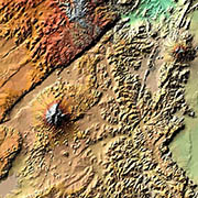
TanDEM-X - Digital Elevation Model (DEM) - Global, 30m
TanDEM-X (TerraSAR-X add-on for Digital Elevation Measurements) is an Earth observation radar mission that consists of a SAR interferometer built by two almost identical satellites flying in close formation. With a typical separation between the satellites of 120m to 500m a global Digital Elevation Model (DEM) has been generated.
The main objective of the TanDEM-X mission is to create a precise 3D map of the Earth's land surfaces that is homogeneous in quality and unprecedented in accuracy. The data acquisition was completed in 2015 and production of the global DEM was completed in September 2016. The absolute height error is with about 1m an order of magnitude below the 10m requirement.
The TanDEM-X 30m DEM is a product variant of the global Digital Elevation Model (DEM) acquired in the frame of the German TanDEM-X mission between 2010 and 2015, and has a reduced pixel spacing of 1 arcsecond (30m at the equator). It covers all Earth’s landmasses from pole to pole.
For more information concerning the TanDEM-X mission, the reader is referred to: https://www.dlr.de/dlr/en/desktopdefault.aspx/tabid-10378/
Simple
- Date (Creation)
- 2018-11-28T12:00:00
- Citation identifier
- https://geoservice.dlr.de/catalogue/srv/metadata/8545a026-2e0c-466f-b6de-99faa639e3c0
- Presentation form
- Digital map
- Purpose
-
The main objective of the TanDEM-X mission is to generate a high resolution, homogeneous global digital elevation model.
- Status
- Completed
- Maintenance and update frequency
- As needed
- Keywords
-
-
TanDEM-X
-
Digital Elevation Model
-
TDX-1
-
TSX-1
-
SAR
-
X-Band
-
TDM-DEM-30m
-
urn:eop:DLR:EOWEB:TDM-DEM-30m
-
Global
-
FEDEO
-
-
GEMET - INSPIRE themes, version 1.0
-
-
Elevation
-
- Use limitation
-
Nutzungseinschränkungen: Das DLR ist nicht haftbar für Schäden, die sich aus der Nutzung ergeben. Use Limitations: DLR not liable for damage resulting from use.
- Access constraints
- Other restrictions
- Other constraints
-
Restricted
- Use constraints
- Other restrictions
- Other constraints
-
License
- Spatial representation type
- Grid
- Denominator
- 60000
- Language
- English
- Character set
- UTF8
- Topic category
-
- Elevation
))
- Begin date
- 2010-12-12T04:04:33
- End date
- 2015-01-16T00:37:12
- Unique resource identifier
- EPSG:4326
- Number of dimensions
- 3
- Dimension name
- Column
- Dimension size
- 1296001
- Resolution
- 30 m
- Dimension name
- Row
- Dimension size
- 626401
- Resolution
- 30 m
- Dimension name
- Vertical
- Dimension size
- 1
- Resolution
- 1 m
- Cell geometry
- Area
- Transformation parameter availability
- No
- Distribution format
-
- OnLine resource
-
TanDEM-X DEM access - non-scientific users
(
WWW:LINK-1.0-http--link
)
Webpage for accessing/ordering TanDEM-X elevation models for non-scientific users.
- OnLine resource
-
TanDEM-X DEM access - scientific users
(
WWW:LINK-1.0-http--link
)
Webpage with links and description for accessing TanDEM-X elevation models for scientific users.
- OnLine resource
-
EOWEB Collection
(
WWW:LINK-1.0-http--link
)
EOWEB Collection (TDM-DEM-30m)
- Hierarchy level
- Dataset
Domain consistency
- Measure identification
- INSPIRE / Conformity_001
Conformance result
- Date (Publication)
- 2010-12-08
- Explanation
-
See the referenced specification
- Pass
- Yes
- Statement
-
For operational TanDEM-X acquisitions single DEM scenes with an extend of ~30km x 50km are generated by applying bistatic focusing, processing of individual interferograms, subsequent phase unwrapping and geocoding.
Remaining offsets and tilts in these DEM scenes are compensated in a DEM calibration step. Therefore, globally available ICESat (Ice, Cloud and Land Elevation Satellite) data is used as ground control points. Corrections are estimated in a block adjustment approach. The corrected DEM scenes are mosaicked to final DEM tiles. Manually conducted quality analysis is performed for every individual DEM tile. The 12m DEM is used as base data and resampled to 30m.
For more information concerning TanDEM-X DEM product the reader is referred to
https://geoservice.dlr.de/web/dataguide/tdm90/pdfs/TD-GS-PS-0021_DEM-Product-Specification.pdf
Note:
Latitude pixel spacing:
• 1.0 arc-seconds
Longitude pixel spacing:
• 0° – 50° North/South: 1.0 arc-seconds
• 50° – 60° North/South 1.5 arc-seconds
• 60° – 70° North/South 2.0 arc-seconds
• 70° – 80° North/South 3.0 arc-seconds
• 80° – 85° North/South 5.0 arc-seconds
• 85° – 90° North/South 10.0 arc-seconds
- Description
-
TanDEM-X Acquisition Planning:
Data:
TanDEM-X will map all land masses on Earth at least twice by using single-pass SAR interferometry. The acquisition concept foresees a first global coverage at larger heights of ambiguity as a robust data basis, and a second global coverage at smaller heights of ambiguity to improve the height accuracy and resolve phase unwrapping problems by dual-baseline processing. Additionally, difficult terrain like mountains will be imaged from another viewing direction in order to cover areas affected by radar shadow.
Quality Assurance:
The TanDEM-X ground segment has several feedback loops about the status and quality of single acquisitions that contribute to the global coverage as well as of the final DEM. The TanDEM-X acquisition planning tracks missing data coverage due to failures in the acquisition process or insufficient performance of single acquisitions. In such cases, the single acquisitions are re-scheduled or further acquisitions are planned in order to fill up the data gaps.
- Description
-
Integrated TanDEM Processor (ITP)
Processing:
Each data take is screened to assess its quality and to estimate consistent calibration and processing parameters (Doppler centroid, bistatic synchronization phase offsets, geometric parameters etc.) for an entire acquisition. The acquisition is then split into slightly overlapping scenes which are processed independently and in parallel. Both (bistatic) channels are focused, co-registered by adaptive resampling and formatted to co-registered single-look slant-range complex (CoSSC) products which are corrected for all bistatic system effects. The shifts determined from the correlation of the two focused complex images are exploited to generate a coarse but absolute DEM using the stereo-radargrammetric viewing geometry. Then an interferogram is calculated from the CoSSCs with a multi-looking factor adapted to the targeted DEM posting. The ambiguous phases are unwrapped either using the “single-baseline” MCF-algorithm or (depending on the data quality and availability of additional data sets) a multi-baseline phase unwrapping (MB-PU) approach. The MB-PU algorithm uses previously processed, archived CoSSCs from overlapping acquisitions with different baselines and hence heights of ambiguity (HoAs) to resolve the ambiguity number of each region in the current interferogram from the larger HoA of a differential interferogram. This can only be done if additional acquisitions are available at the time of processing, their HoA ratios are favorable (i.e. close to 0.7), both data sets are coherent (“compatible”) and do not show larger temporal height discrepancies. The different parts of the interferogram is then mosaicked from the suitable overlapping image parts to the resulting unwrapped phase data set. Incompatible and parts without supporting data are masked out in this step. The absolute phase offset ambiguity is solved using the coarse radargram as reference. Subsequent geocoding of the unwrapped data applies external corrections like atmospheric delay compensation to provide best possible absolute heights. It generates the so called RawDEM which includes the DEM data, geocoded amplitudes, height error estimates based on coherence and a flag mask along with numerous additional files, quicklooks and parameter sets for quality control and (bistatic) system calibration.
Quality Assurance:
Instrument problems detected during processing from limit violations result in products flagged by the ITP as unprocessable. The ITP provides quality control data sets including differences to reference data (SRTM, GLOBE) for visual checks but its processing is based solely on TanDEM-X data alone: The system calibration, the method of radragrammetric offset determination and the precise phase preserving SAR processing which takes all dynamic effects into account yield RawDEMs which are generally within a few meters to absolute reference heights (for bare soil). Some RawDEMs (about 10%) are however systematically off by 1 or more sync phase cycle resulting from the bistatic synchronization link Pi-ambiguity. These cases are automatically detected by the MCP and submitted to reprocessing with a new ambiguity offset for the scene. Re-processing of individual scenes includes only interferometric processing steps starting from the archived CoSSC products (thus keeping the original calibration parameters for consistent processing) and replaces the RawDEMs. Larger phase-unwrapping problems are detected by the automatic comparison of the coarse radargram and the unwrapped phases in the ITP and flagged accordingly. Smaller errors or undetected errors in incoherent data sets are flagged by the MCP and its operators for reprocessing. Based on quality remarks given by MCP, different correction scenarios may be invoked in the ITP. Specifically data from the first mission phase had to be processed as single-baseline and thus exhibits the expected unwrapping problems. The re-processing takes place shortly before the final MCP-processing and uses all (newly) available acquisitions with different HoAs for MB-PU processing to correct such errors. Combinations of unwrapping errors and sync-link ambiguities may require iterative re-processing runs.
- Description
-
Mosaicking and Calibration Processor (MCP)
Processing:
Each RawDEM is automatically passed to the MCP DEM Preparation Processor. The MCP performs a first analysis of the data which comprises a height discrepancy detection (vs. SRTM, ICESat and other TanDEM-X acquisitions), a water body detection (based on amplitude and coherence), and the extraction of calibration points as input for the DEM calibration processor.
The DEM Calibration Processor estimates remaining systematic height errors - an offset and slopes in range and azimuth - by least-squares adjustment of adjacent DEM acquisitions. The calibration points used are Tie-Points, i.e. identical points present in different RawDEMs and ground control points, i.e. ICESat-Points, which are used as absolute height reference data.
The DEM Mosaicking Processor combines the information contained in different RawDEMs. The calibrated corrections are applied to each RawDEM before mosaicking. In addition to the digital elevation model the following auxiliary layers are generated: height error map, water mask, mean amplitude, minimum amplitude, coverage map, consistency mask, and layover-shadow mask.
Quality Assurance:
The DEM Preparation Processor automatically checks quality parameters in order to identify good and bad RawDEMs, respectively. If the automatic check does not provide a unique result, an operator checks the RawDEM and assigns the corresponding quality remark. Bad quality RawDEMs are sent back to the Integrated TanDEM Processor (ITP) for re-processing. Good quality RawDEMs are stored in the archive for later calibration and mosaicking.
After calibration an interactive quality control of the estimated corrections is performed. Therefore, differences between Tie-Points and differences to ICESat-Points are compared before and after calibration. Each DEM tile produced by the Mosaicking Processor is automatically compared to validation ICESat points (excluding the points used for calibration). A globally distributed set of GPS tracks is also used to confirm the data quality as well as comparisons to SRTM. Furthermore each DEM tile is inspected by an operator. If the quality is insufficient, the tile is not approved. In case the operator makes observations leading to limited approval, an additional remark is assigned to the product. If the quality of the tile is ok, the product is approved.
- Description
-
Data Archiving:
Two copies of all acquired (TDM.SAR.L0) and processed (TDM.SAR.COSSC, TDM.DEM.RAW, TDM.DEM.*DEM) data of the TanDEM-X mission are archived in the German Satellite Data Archive (D-SDA) at DLR-DFD. In general it is not foreseen to delete any of the processed data. Only if processed data are unusable and are being reprocessed, the original version may be deleted.
Data Delivery:
The following TanDEM-X products are available in the EOWEB-Catalogue:
• TDM.SAR.CoSSC
• TDM.DEM.IDEM (intermediate DEM)
• TDM.DEM.DEM (final DEM)
Access to these collections is limited to
• Ground segment internal
• Infoterra (ITD) as commercial user
• Science User with an accepted proposal
The data are delivered online using ftps/sftp.
- File identifier
- 8545a026-2e0c-466f-b6de-99faa639e3c0 XML
- Metadata language
- English
- Character set
- UTF8
- Hierarchy level
- Dataset
- Date stamp
- 2024-09-27T12:48:49
- Metadata standard name
-
ISO 19115:2014/19139
- Metadata standard version
-
1.0
Overviews

Spatial extent
Provided by
