 www.geodatenkatalog.de (S1L)
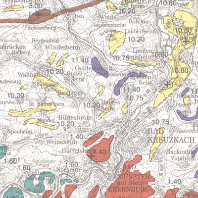
Map of the raw materials close to the surface in the Federal Republic of Germany 1:200,000 (KOR200) - CC 7942 Passau
In order to exploit mineral raw materials close to the Earth's surface, experts are working on trans-regional and national planning documents. To do this, they need maps which clearly depict the raw materials close to the surface in Germany. KOR200 displays Germany's national raw material potential in a comparable way, thus forming a basis for future exploration and investigations as well as making a contribution towards the assurance of the supply of raw materials. The map follows the sheet line system of the topographical survey map 1:200.000 (TÜK 200) and consists of 55 sheets, each with an explanatory booklet. There is a review of the current situation, a description, a depiction and documentation of the occurrence and deposits of mineral raw materials which are usually extracted in mines either on or close to the Earth's surface. Such deposits include, in particular, industrial minerals, rocks and soils, peat, lignite, oil shale and brines. Besides the delimited deposits and areas of raw materials coloured according to the raw material in question, the maps also depict "mining areas" (=operations) or "focal points of several mining areas", each marked with a symbol. The map entries are - just as with the topographical basis - recorded in digitalised form in a databank, from which they can be retrieved via a computer using various search criteria. The entries in the map are supplemented by between 40 to 80 pages of textual explanations, which are currently available only in the printed edition of the map. The text is divided into: - introduction - description of the deposits and occurrence of useful rocks - supply and demand assessment of the deposits and occurrence of raw materials close to the Earth's surface in the area covered by the sheet - possible ways of using the useful rocks present in the sheet area - list of publications - appendix (with, amongst other things, a general legend and survey of sheets)
|
|
Citation proposal
(2006) . Map of the raw materials close to the surface in the Federal Republic of Germany 1:200,000 (KOR200) - CC 7942 Passau. https://gdk.gdi-de.org/geonetwork/srv/api/records/8725750B-54AC-45CC-BFB6-F4CD46109040 |
INSPIRE
Identification
- File identifier
- 8725750B-54AC-45CC-BFB6-F4CD46109040 XML
- Hierarchy level
- dataset Dataset
Online resource
Resource identifier
- code
- 0D649C08-65A1-42A1-9D6D-F4BD39D348F0
- Metadata language
- ger German
- Spatial representation type
- Grid
- Spatial representation type
- Vector
Encoding
- Format
- Version
- n/a
- Format
- Shapefile
- Version
- n/a
- Format
- JPEG
- Version
- n/a
- Format
- TIFF
- Version
- n/a
- Format
- gedruckt
- Version
- n/a
Projection
Classification of data and services
- Topic category
-
- Economy
Classification of data and services
Coupled resource
Coupled resource
Classification of data and services
Coupled resource
Coupled resource
Keywords
- GEMET - INSPIRE themes, version 1.0 ( Theme )
-
- Geologie
- Geology
- GEMET - Concepts, version 2.4 ( Theme )
-
- raw material
- Rohstoff
Other keywords
- Keywords ( Theme )
-
- Aigen
- Altötting
- Braunau
- Donau
- Grieskirchen
- Inn
- Isar
- Karte
- Mineralien
- ökonomisch
- Mineralvorkommen
- Passau
- Pfaffkirchen
- Ressource
- Ried
- Rohstoffindustrie
- Salzach
- Sand
- Ton
- Torf
- Traun
- Vöcklabruck
- Wirtschaft
- Keywords ( Place )
-
- Bayern
- Keywords ( Place )
-
- Östereich
Geographic coverage
N
S
E
W
))
Temporal reference
Temporal extent
Temporal extent
- Date ( Publication )
- 2006-12-31
Quality and validity
- Lineage
- Erarbeitung auf Grundlage rohstoffgeologischer Daten und - Karten der Staatlichen Geologischen Dienste Deutschlands. -
- Denominator
- 200000
Conformity
Conformity
Conformity
Conformity
Conformity
Conformity
Restrictions on access and use
- Access constraints
- Allgemeine Geschäftsbedingungen, s. https://www.bgr.bund.de/agb - General Terms and Conditions, s. https://www.bgr.bund.de/agb_en
- Access constraints
- Preis der gedruckten Karte: 23,36 EUR (zzgl. 7% MWSt. und Versandkosten) Weitere Informationen zur Bestellung beim Internationalen Landkartenhaus siehe https://www.bgr.bund.de/produktcenter-bestellhinweis-ILH
Restrictions on access and use
Responsible organization (s)
Contact for the resource
- Organisation name
- Bundesanstalt für Geowissenschaften und Rohstoffe
Responsible organization (s)
Contact for the resource
- Organisation name
- Bundesanstalt für Geowissenschaften und Rohstoffe
Metadata information
Contact for the metadata
- Organisation name
- Bundesanstalt für Geowissenschaften und Rohstoffe (BGR)
- Date stamp
- 2023-04-13
- Metadata language
- German
- Character set
- utf8 UTF8
SDS
Conformance class 1: invocable
Access Point URL
Endpoint URL
Technical specification
Conformance class 2: interoperable
Coordinate reference system
Quality of Service
Access constraints
Limitation
Use constraints
Limitation
Responsible custodian
Contact for the resource
Conformance class 3: harmonized
Overviews
Provided by

Views
8725750B-54AC-45CC-BFB6-F4CD46109040
Access to the portal
Read here the full details and access to the data.
Associated resources
Not available