 www.geodatenkatalog.de (S2F)
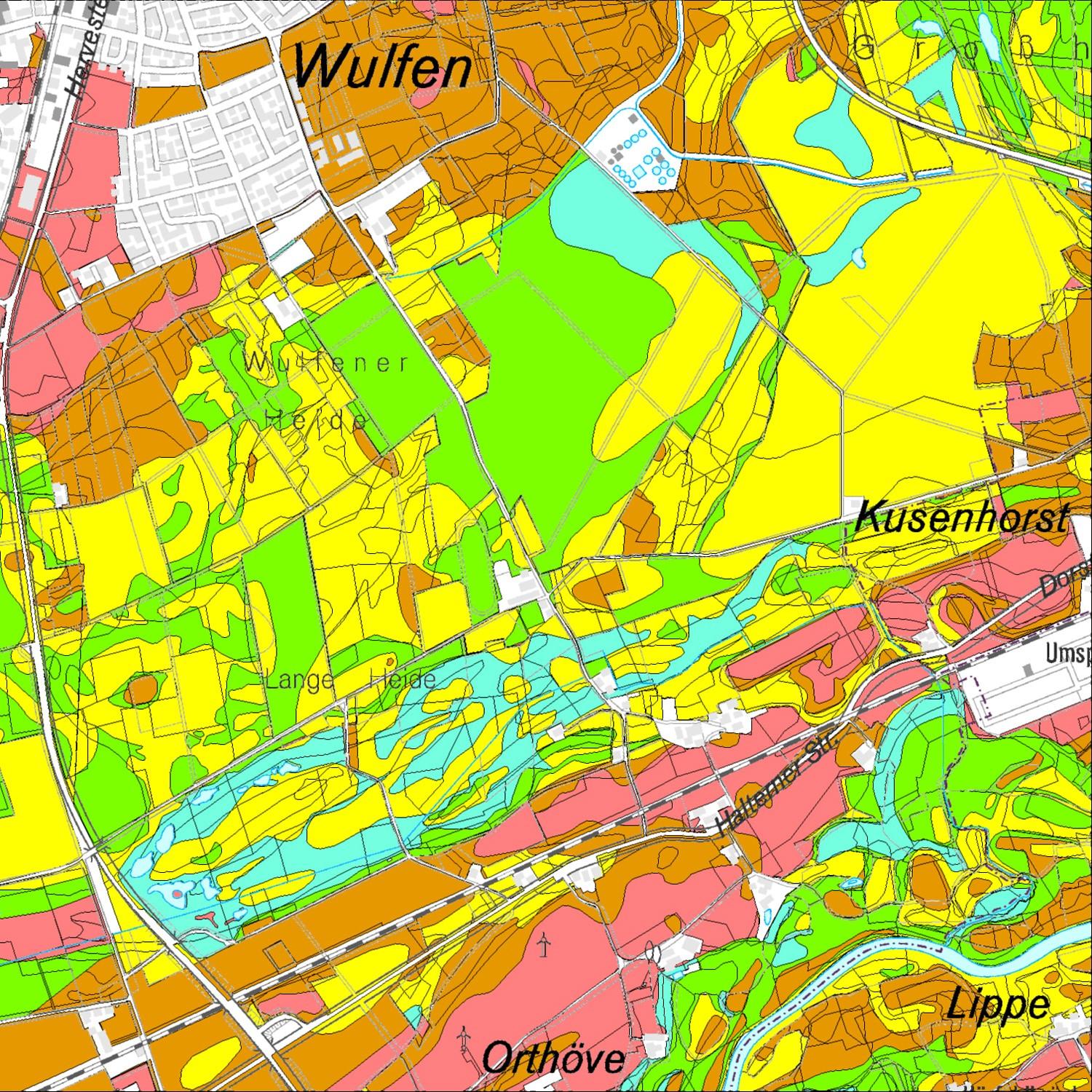
Bodenfunktionskarte (Kreis Recklinghausen / Anwendung)
Interaktive Darstellung der Bodenfunktionskarte im Kreis Recklinghausen.
Bodenfunktionskarten beschreiben den Ist-Zustand des Bodens und dienen den Behörden wie auch externen Planern als grundsätzliche Bewertungsgrundlage. Sie zeigen Bodenbereiche auf, die auf Grund Ihrer Seltenheit, Ihrer natürlichen Bodenfruchtbarkeit oder Ihrer Stellung im Gesamtgefüge des Naturhaushaltes besonders schützenswert sind und stellen darüber hinaus die unterschiedlichen Bodenfunktionen dar.
Die Bodenfunktionskarte, deren Erstellung im Dezember 2017 abgeschlossen wurde, dient als Leitinstrument der Identifikation und dem Schutz schützenswerter Böden. Ziel ist der sparsame und schonende Umgang mit der endlichen Ressource. Anwendung findet die Bodenfunktionskarte daher unter anderem im Bereich kommunaler Planungsprozesse wie bei der Bewertung von Eingriffen.
|
|
Citation proposal
(2019) . Bodenfunktionskarte (Kreis Recklinghausen / Anwendung). https://gdk.gdi-de.org/geonetwork/srv/api/records/87f33e63-152a-4156-8f42-5cde840143f6 |
INSPIRE
Identification
- File identifier
- 87f33e63-152a-4156-8f42-5cde840143f6 XML
- Hierarchy level
- Software
Online resource
- Protocol
- WWW:LINK-1.0-http--link
Resource identifier
Encoding
- Format
- Webadresse
- Version
Projection
Classification of data and services
Classification of data and services
- Service Type
- application
- Coupling Type
- Loose
Coupled resource
Coupled resource
Classification of data and services
- Service Type
- application
- Coupling Type
- Loose
Coupled resource
Coupled resource
Keywords
- GEMET ( Theme )
-
- Bodenfunktion
- Boden
- Bodenfruchtbarkeit
- GovData ( Theme )
-
- Umwelt und Klima
- Region ( Place )
-
- Kreis Recklinghausen
Other keywords
- Keywords ( Theme )
-
- Ausgleichskörper Wasserkreislauf
- Biotopentwicklungspotential
- Filter- und Pufferfunktion
Geographic coverage
))
Temporal reference
Temporal extent
Temporal extent
- Date ( Publication )
- 2019-07-08T08:00:00
Quality and validity
Conformity
Conformity
Conformity
Conformity
Conformity
Conformity
Restrictions on access and use
Restrictions on access and use
- Access constraints
- Zur Einsichtnahme
Responsible organization (s)
Contact for the resource
- Organisation name
- Kreisverwaltung Recklinghausen
- Organisation name
- Kreisverwaltung Recklinghausen
Responsible organization (s)
Contact for the resource
- Organisation name
- Kreisverwaltung Recklinghausen
- Organisation name
- Kreisverwaltung Recklinghausen
Metadata information
Contact for the metadata
- Organisation name
- Kreisverwaltung Recklinghausen
- Date stamp
- 2023-04-13T11:11:10
- Metadata language
- German
SDS
Conformance class 1: invocable
Access Point URL
Endpoint URL
Technical specification
Conformance class 2: interoperable
Coordinate reference system
Quality of Service
Access constraints
Limitation
Use constraints
Limitation
- string
- Zur Einsichtnahme
Responsible custodian
Contact for the resource
Conformance class 3: harmonized
Contains Operations
- Operation Name
- Registry-ID
Overviews
Provided by
