 www.geodatenkatalog.de (S3F)
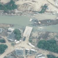
WMS RP DOP40_Sonderbefliegung_Hochwasser - RP DOP40rgb Sonderbefliegung Hochwasser Ahr 2021 rgb
Dieser Web Map Service transportiert die abgeleiteten Rasterbilder der Digitalen Orthophotos DOP40_Sonderbefliegung_Hochwasser entsprechend dem Produkt- und Qualitätsstandard für Digitale Orthophotos (www.adv-online.de). Die Ausgangsdaten liegen in folgender Ausprägung vor: rgb - Es handelt sich um eine Darstellung als 3-Kanal-Echtfarbbild (Rot - Grün - Blau):3-Kanal-Echtfarbbild (rgb) des DOP40. Digitale Orthophotos; Bodenauflösung 40 cm/Pixel.
|
|
Citation proposal
. WMS RP DOP40_Sonderbefliegung_Hochwasser - RP DOP40rgb Sonderbefliegung Hochwasser Ahr 2021 rgb. Landesamt für Vermessung und Geobasisinformation (LVermGeo) Rheinland-Pfalz https://gdk.gdi-de.org/geonetwork/srv/api/records/88320da6-300c-e7b4-722a-e8b2f25e0436 |
Simple
Identification info
- Alternate title
- Digitale Orthophotos
- Date ( Revision )
- 2025-01-21
Publisher
- mapbender.2.registryId
-
- 2f23ed6e-0186-4c2b-8380-748389036509
- Keywords
-
- Digitale Orthophotos
- Sonderbefliegung Hochwasser
- Digitales Orthophoto
- Landesvermessung
- WMS_RP_DOP40
- 40cm
- 40 cm
- Geobasisdaten
- AdV
- Arbeitsgemeinschaft der Vermessungsverwaltungen der Länder
- ATKIS
- WMS
- RP
- Rheinland-Pfalz
- DOP
- DOP40
- Digitale Orthophotos 40cm
- Luftbilder
- AdVMIS
- Ahr
- Flut
- Katastrophe
- infoMapAccessService
- Access constraints
- Other restrictions
- Use constraints
- Other restrictions
- Other constraints
- geldleistungsfrei, Datenlizenz Deutschland – Namensnennung – Version 2.0, URL: https://www.govdata.de/dl-de/by-2-0 - Lizenz: dl-de-by-2.0 - Datenlizenz Deutschland Namensnennung 2.0 - https://www.govdata.de/dl-de/by-2-0 - Quellenvermerk: ©GeoBasis-DE / LVermGeoRP (Jahr des Datenbezugs), dl-de/by-2-0, http://www.lvermgeo.rlp.de [Daten bearbeitet]
- Other constraints
- {"id":"dl-de-by-2.0","name":"Datenlizenz Deutschland Namensnennung 2.0","url":"https:\/\/www.govdata.de\/dl-de\/by-2-0","quelle":"\u00a9GeoBasis-DE \/ LVermGeoRP (Jahr des Datenbezugs), dl-de\/by-2-0, http:\/\/www.lvermgeo.rlp.de [Daten bearbeitet]"}
- Service Type
- view
- Service Version
- OGC:WMS 1.1.1
N
S
E
W
))
- Coupling Type
- Tight
Contains Operations
- Operation Name
- GetCapabilities
- Distributed Computing Platforms
- Web services
- Distribution format
-
- ()
- OnLine resource
-
rp_dop40_sonderbefliegung_hochwasser_ahr_2021_rgb
3-Kanal-Echtfarbbild (rgb) des DOP40. Digitale Orthophotos; Bodenauflösung 40 cm/Pixel.
- Hierarchy level
- service Service
- Other
- Dienst
Conformance result
- Date ( Publication )
- 2010-12-08
- Explanation
- No explanation available
- Pass
- true
Conformance result
- Date ( Publication )
- 2009-10-20
- Explanation
- No explanation available
- Pass
- true
Conformance result
- Date ( Publication )
- 2014-12-11
- Explanation
- No explanation available
- Pass
- true
Conformance result
- Date ( Publication )
- 2008-12-04
- Explanation
- No explanation available
- Pass
- true
Conformance result
- Date ( Publication )
- 2014-12-11
- Explanation
- No explanation available
- Pass
- true
Conformance result
- Date ( Publication )
- 2013-12-10
- Explanation
- No explanation available
- Pass
- true
Conformance result
- Date ( Publication )
- 2011-02-05
- Explanation
- No explanation available
- Pass
- true
Conformance result
- Date ( Publication )
- 2010-12-08
- Explanation
- No explanation available
- Pass
- true
gmd:MD_Metadata
- File identifier
- 88320da6-300c-e7b4-722a-e8b2f25e0436 XML
- Metadata language
- Deutsch German
- Character set
- UTF8
- Hierarchy level
- service Service
- Hierarchy level name
- Darstellungsdienst
- Date stamp
- 2025-06-08
- Metadata standard name
- ISO19119
- Metadata standard version
- 2005/PDAM 1
Point of contact
Overviews
Thumbnail
Provided by

Views
88320da6-300c-e7b4-722a-e8b2f25e0436
Access to the portal
Read here the full details and access to the data.
Associated resources
Not available