 www.geodatenkatalog.de (S1L)
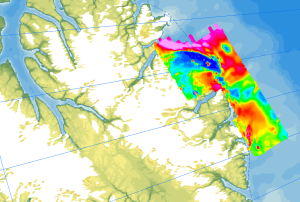
Helicopter-borne Magnetics in the Arctic region (WMS)
The study of the geodynamic evolution of the Arctic continental margin and opening of the Arctic Ocean represents a primary target of BGR research and is studied within the frame of the CASE programme. In addition to onshore geological investigations, BGR conducts airborne aeromagnetic surveys. The available service contains the results of aeromagnetic surveys from the CASE program as well as cooperation projects (PMAP, NARES & NOGRAM), which were obtained with helicopters or fixed-wing aircraft in the Arctic.
|
|
Citation proposal
Bundesanstalt für Geowissenschaften und Rohstoffe (BGR) (2023) . Helicopter-borne Magnetics in the Arctic region (WMS). https://gdk.gdi-de.org/geonetwork/srv/api/records/88788be0-815d-413b-bcc2-b2bf79ac66ce |
Simple
Identification info
- Alternate title
- AeromagArctic (WMS)
- Date ( Publication )
- 2023-02-22
- Identifier
- 1e243b61-7b52-18a7-d84f-9b1bef72ae3a
- Status
- completed Completed
Point of contact
Bundesanstalt für Geowissenschaften und Rohstoffe (BGR)
-
Ruppel, Antonia, Dr.
Stilleweg 2
Hannover
30655
Deutschland
- Keywords ( Theme )
-
- Geology
- Geologie
- Aerogeophysik
- Aeromagnetik
- Anomalien des erdmagnetischen Feldes
- Airborne geophysics
- helicopter-borne /fixed-wing magnetics
- anomalies of the Earth’s magnetic field
- Keywords ( Place )
-
- Arktis
- Arctic
- Nordpolargebiet
- North Polar
- Access constraints
- Other restrictions
- Use constraints
- Other restrictions
- Other constraints
- Allgemeine Geschäftsbedingungen, siehe https://www.bgr.bund.de/AGB - General terms and conditions, see https://www.bgr.bund.de/AGB_en. Die bereitgestellten Informationen sind bei Weiterverwendung wie folgt zu zitieren: Datenquelle: AeromagArctic, (c) BGR, Hannover, 2023
- Service Type
- view
- Service Version
- OGC:WMS 1.3.0
N
S
E
W
))
Coupled Resource
- Operation Name
- GetMap
- Identifier
- 26e3620c-e9f5-1010-d301-eb81f3268a5b
Coupled Resource
- Operation Name
- GetMap
- Identifier
- afb3116e-5c1b-4f53-a7a2-495aab80faf7
Coupled Resource
- Operation Name
- GetMap
- Identifier
- 6546c4bf-d318-8ca5-e18c-876eb3f4c893
Coupled Resource
- Operation Name
- GetMap
- Identifier
- 8ca95462-0160-76bf-9c5e-865b2131afaa
Coupled Resource
- Operation Name
- GetMap
- Identifier
- d9eb00fe-93f2-ee92-1102-eb9081d484c4
Coupled Resource
- Operation Name
- GetMap
- Identifier
- e99937e5-a02d-63ad-7afa-5afe19039d3e
Coupled Resource
- Operation Name
- GetMap
- Identifier
- aa329603-372d-e3ea-b613-5c047fd9f383
- Coupling Type
- Tight
Contains Operations
- Operation Name
- GetCapabilities
- Distributed Computing Platforms
- Web services
Contains Operations
- Operation Name
- GetMap
- Distributed Computing Platforms
- Web services
- Distribution format
-
- png (n/a )
- jpeg (n/a )
- gif (n/a )
- OnLine resource
- https://services.bgr.de/wms/aerogeophysik/aeromagarctic/?REQUEST=GetCapabilities&SERVICE=wms&VERSION=1.3.0
- OnLine resource
-
Karte im BGR-Geoviewer
Karte im BGR-Geoviewer
- Hierarchy level
- Service
- Other
- Service
- Statement
- The datasets contain the results of aeromagnetic surveys from the CASE program as well as cooperation projects (PMAP, NARES & NOGRAM), which were obtained with helicopters or fixed-wing aircraft in the Arctic.
gmd:MD_Metadata
- File identifier
- 88788be0-815d-413b-bcc2-b2bf79ac66ce XML
- Metadata language
- English
- Character set
- UTF8
- Hierarchy level
- Service
- Hierarchy level name
- Geologie
- Date stamp
- 2024-01-24
- Metadata standard name
- INSPIRE Metadata Implementing Rules: Technical Guidelines based on EN ISO 19115 and EN ISO 19119
- Metadata standard version
- n/a
Point of contact
Overviews
Provided by

Views
88788be0-815d-413b-bcc2-b2bf79ac66ce
Access to the portal
Read here the full details and access to the data.
Associated resources
Not available