 www.geodatenkatalog.de (S3L)
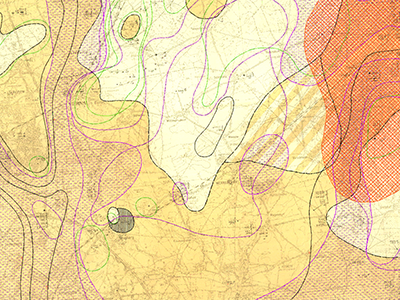
Lithofacial Map of the Quaternary 1 : 50.000 - Digitized data Sheet 1968 Berlin/Nordost
The Lithofacial Map of the Quaternary 1 : 50,000 (LKQ 50) is a map series of the GDR covering nearly the whole former state territory besides the South of Saxony and Thuringia. The series consists of 123 map sheets, each of which encompassing several horizon maps mostly complemented by about five cross sections. Specifications concerning map content and structure provides Cepek (1999). The data of the LKQ 50 map sheet 1968 Berlin/Nordost provided here were digitised in frame of the Geo3D-Oder project of the German Federal Institute for Geosciences and Natural Resources (BGR). The data include elements of the seven horizon maps 1968-2, 1968-3, 1968-4, 1968-5, 1968-6, 1968-7, and 1968-8. Sheet 1968 Berlin/Nordost was published at an early stage of the map series preparation in 1972. Therefore, the topics of these maps are defined in a primary version 1 of the general legend. In contrast to map sheets of a later publication date the single horizon maps of 1968 Berlin/Nordost lack map legends to provide a specific stratigraphic and genetic classification of the depicted strata. However, as each horizon map comprises just two to four layers, this assignment can be derived from the signatures and the stratigrafic indication of the respective horizon map. For each horizon map the digitised elements comprise several polygon shapefiles of the single layers, a polyline shapefile of isohypses related to layer bases, a point shapefile of lithological profiles and a polygon shapefile of additional information concerning areas of heavy strata deformation and insufficient investigation. Non-numeric contents of the attribute tables are encoded by numbers and are translated in full text by means of key tables. The key table Normalprofil allows the stratigraphic and genetic classification of horizons displayed in horizon maps by code numbers of the column N_ID. Detailed descriptions concerning the data structure are provided in the attachments. Reference: Cepek, A. G. (1999): Die Lithofazieskarte Quartär 1 : 50.000 (LKQ 50) – Eine Erläuterung des Kartenkonzepts mit Hinweisen zum Gebrauch. - Brandenburgisch. Geowiss. Beitr. 6, 2: 3-38, 3 Abb., 2 Tab.; Kleinmachnow
|
|
Citation proposal
(2024) . Lithofacial Map of the Quaternary 1 : 50.000 - Digitized data Sheet 1968 Berlin/Nordost. https://gdk.gdi-de.org/geonetwork/srv/api/records/8a16390b-9a64-48ef-b3c4-c815466e5129 |
Simple
- Alternate title
- LKQ50 - 1968 Berlin/Nordost
- Date ( Publication )
- 2024-03-25
- Edition
- Version 1
Author
Author
- Other citation details
- Bundesanstalt für Geowissenschaften und Rohstoffe (BGR): Lithofazieskarte Quartär 1 : 50.000 - Kartenblatt 1968 Berlin/Nordost (LKQ 50 - 1968 Berlin/Nordost). Digitaler Datenbestand, Version 1 (2024) - Berlin
- Status
- historicalArchive Historical archive
Point of contact
- GEMET - INSPIRE themes, version 1.0
-
- Geologie
- Keywords ( Theme )
-
- Lithofazieskarte
- Quartär
- LKQ
- 1968
- Keywords ( Place )
-
- Brandenburg
- Berlin
- Berlin/Nordost
- Classification
- Unclassified
- Access constraints
- Other restrictions
- Use constraints
- Other restrictions
- Other constraints
- Allgemeine Geschäftsbedingungen, siehe https://www.bgr.bund.de/AGB - General terms and conditions, see https://www.bgr.bund.de/AGB_en. Die bereitgestellten Informationen sind bei Weiterverwendung wie folgt zu zitieren: Datenquelle: LKQ 50, (C) BGR, Hannover, 2024.
- Spatial representation type
- Vector
- Spatial representation type
- Grid
- Denominator
- 50000
- Metadata language
- German
- Character set
- UTF8
- Topic category
-
- Geoscientific information
N
S
E
W
))
- Distribution format
-
- mxd (10.8 )
- OnLine resource
-
Karte im Format ESRI ArcGIS Map
Karte im Format ESRI ArcGIS Map
- Hierarchy level
- Dataset
- Statement
- Digitalisierung analoger Karten
gmd:MD_Metadata
- File identifier
- 8a16390b-9a64-48ef-b3c4-c815466e5129 XML
- Metadata language
- German
- Character set
- UTF8
- Parent identifier
- 3b88b2a2-6656-4fd7-a3c6-9b62b7c7c486
- Hierarchy level
- Dataset
- Hierarchy level name
- Geologie
- Date stamp
- 2024-04-16
- Metadata standard name
- INSPIRE Metadata Implementing Rules: Technical Guidelines based on EN ISO 19115 and EN ISO 19119
- Metadata standard version
- Version 2.0.1
Point of contact
Overviews
Provided by

Views
8a16390b-9a64-48ef-b3c4-c815466e5129
Access to the portal
Read here the full details and access to the data.
Associated resources
Not available