 www.geodatenkatalog.de (S1L)
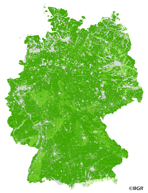
Relative binding strength of copper in German topsoils
The map of the relative binding strength of copper in topsoils (0-30 cm) gives an overview of the sorption of this heavy metal in the soils of Germany. A high binding strength of copper can reduce the harmful impact on the environment by a decreased mobility. The basis for calculation of the binding strength was the soil map 1:1,000,000 (BÜK1000) as well as linking rules and tabular values of copper binding from Hennings et al. (2000). The binding strength of copper depends on the pH, the content of organic matter and the soil texture (proxy for the content of clay minerals and sesquioxides) in this evaluation. The used pH was the target pH value of the soils, which was derived from tabular values according to land use by using the data of the BUEK1000.
|
|
Citation proposal
(2015) . Relative binding strength of copper in German topsoils. https://gdk.gdi-de.org/geonetwork/srv/api/records/8b4739c7-360a-486e-9ca3-ad49c239fd31 |
INSPIRE
Identification
- File identifier
- 8b4739c7-360a-486e-9ca3-ad49c239fd31 XML
- Hierarchy level
- Dataset
Online resource
Resource identifier
- code
- d0f08fdc-c409-417d-badc-c54863210c70
- Metadata language
- German
- Spatial representation type
- Grid
Encoding
- Format
- georef. TIFF
- Version
- n/a
Projection
Classification of data and services
- Topic category
-
- Geoscientific information
Classification of data and services
Coupled resource
Coupled resource
Classification of data and services
Coupled resource
Coupled resource
Keywords
- GEMET - INSPIRE themes, version 1.0 ( Theme )
-
- Boden
- Soil
- GEMET - Concepts, version 2.4 ( Theme )
-
- Adsorption
- Bodenart
- Bodenchemie
- Bodenkarte
- Bodenkunde
- Bodenprozess
- Bodenschadstoff
- Humus
- Organische Substanz
- Pedosphäre
- Sorption
- Kupfer
- Schwermetall
- Freies Schlagwort ( Theme )
-
- Sorptionsstärke
- Relative Bindungsstärke
- Oberboden
- pH-Wert
- Verknüpfungsregeln
- FISBo BGR
Other keywords
- Keywords ( Place )
-
- Bundesrepublik Deutschland
Geographic coverage
N
S
E
W
))
Temporal reference
Temporal extent
Temporal extent
- Date ( Creation )
- 2014-06-20
- Date ( Publication )
- 2015-08-03
Quality and validity
- Lineage
- Bodendaten aus BÜK1000N (BGR). Methoden-Wiki im FISBo BGR.
- Denominator
- 1000000
Conformity
Conformity
Conformity
Conformity
Conformity
Conformity
- Explanation
- siehe dazu die angegebene Durchführungsbestimmung
Restrictions on access and use
- Access constraints
- Allgemeine Geschäftsbedingungen, siehe https://www.bgr.bund.de/AGB - General terms and conditions, see https://www.bgr.bund.de/AGB_en. Die bereitgestellten Informationen sind bei Weiterverwendung wie folgt zu zitieren: Datenquelle: FSMCU3DM1000_250 V1.0, (c) BGR, Hannover, 2015.
Restrictions on access and use
Responsible organization (s)
Contact for the resource
- Organisation name
- Bundesanstalt für Geowissenschaften und Rohstoffe (BGR)
- fis.bo@bgr.de
Responsible organization (s)
Contact for the resource
- Organisation name
- Bundesanstalt für Geowissenschaften und Rohstoffe (BGR)
- fis.bo@bgr.de
Metadata information
Contact for the metadata
- Organisation name
- Bundesanstalt für Geowissenschaften und Rohstoffe (BGR)
- Date stamp
- 2023-08-22
- Metadata language
- German
- Character set
- UTF8
SDS
Conformance class 1: invocable
Access Point URL
Endpoint URL
Technical specification
Conformance class 2: interoperable
Coordinate reference system
Quality of Service
Access constraints
Limitation
Use constraints
Limitation
Responsible custodian
Contact for the resource
Conformance class 3: harmonized
Overviews
Provided by

Views
8b4739c7-360a-486e-9ca3-ad49c239fd31
Access to the portal
Read here the full details and access to the data.
Associated resources
Not available