 www.geodatenkatalog.de (S1L)
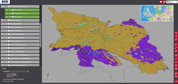
3D-model of the deeper underground of the North German Basin
The „TUNB 3D-model of the North German Basin“ provides information of the spatial distribution of base horizons, salt structures and faults in the North German Basin (On- and Offshore). The model consists of 13 important supra-regional “litho”-stratigraphic base horizons of late Paleozoic to Cenozoic formations. The base of the Late Permian „Zechstein“ forms the base of the model and the base of the Cenozoic „Rupelium“ is the youngest modeled horizon. The digital elevation model (or sea bottom offshore) acts as the top of the model. 273 salt structures were modelled using seismic data, well data and in some cases the depth maps of surrounding horizons. The salt structures are represented by a generalized modelled boundary between salt and surrounding sediment. Due to the large number of faults in the area only selected faults could be incorporated into the model. Faults that are longer than 5 km and offset at least 3 horizons are modelled. Also selected important faults are included into the model even if they don´t match these criteria. Due to its overview scale and necessary generalisations, the model is not suitable for detailed site investigations. The 3D model is the outcome of a joint project coordinated by BGR. The modelling was conducted between 2014 and 2020 by the State Geologic Survey Organisation (GSO) of Schleswig-Holstein (LLUR), Mecklenburg-Vorpommern (LUNG), Brandenburg (LBGR), Sachsen-Anhalt (LAGB) and Niedersachen (LBEG). The area of Hamburg was modelled by LLUR, that of Bremen by LBEG and that of Berlin by the State Geological Survey of Brandenburg (LBGR). The BGR was responsible for modelling the area of the Exclusive Economic Zone of the German North Sea. The authorship of the individual state models lies with the State Geological Surveys, which created them in each case. The software package GOCAD/SKUA by Emerson Paradigm was used to create the model. In this software format the model can also be downloaded. We would like to thank EMERSON E&P for providing Paradigm SKUA-GOCAD and EPOS as part of the Academic Software Program.
|
|
Citation proposal
(2021) . 3D-model of the deeper underground of the North German Basin. https://gdk.gdi-de.org/geonetwork/srv/api/records/8b70fe0f-0b03-477b-a3cd-c0f13a2c41b2 |
INSPIRE
Identification
- File identifier
- 8b70fe0f-0b03-477b-a3cd-c0f13a2c41b2 XML
- Hierarchy level
- Dataset
Online resource
Resource identifier
- code
- 0112783c-f33f-df22-49f7-8d1902548695
- Metadata language
- German
- Spatial representation type
- TIN
Encoding
- Format
- online
- Version
- n/a
- Format
- GOCAD/SKUA
- Version
- n/a
Projection
Classification of data and services
- Topic category
-
- Geoscientific information
Classification of data and services
Coupled resource
Coupled resource
Classification of data and services
Coupled resource
Coupled resource
Keywords
- GEMET - INSPIRE themes, version 1.0 ( Theme )
-
- Geologie
- Geology
- GEMET - Concepts, version 4.1.4 ( Theme )
-
- Modell
Other keywords
- Keywords ( Theme )
-
- Geothermie
- 3D-Horizont
- Strukturgeologie
- Keywords ( Place )
-
- Norddeutsches Becken
- Deutsche Nordsee
Geographic coverage
N
S
E
W
))
Temporal reference
Temporal extent
Temporal extent
- Date ( Publication )
- 2021-01-28
- Date ( Revision )
- 2022-05-11
Quality and validity
- Lineage
- Die Urheberschaft der Landesmodelle zu Niedersachsen & Bremen, Schleswig-Holstein & Hamburg, Brandenburg & Berlin, Sachsen-Anhalt, Mecklenburg-Vorpommern sowie zur Deutschen Nordsee liegt bei den Staatlichen Geologischen Diensten (LBEG, LLUR, LBGR, LAGB, LUNG, BGR), die diese jeweils erstellt haben. Das TUNB-Gesamtmodell als auch die jeweiligen Landesmodelle unterliegen dem deutschen Urheberrecht.
Conformity
Conformity
Conformity
Conformity
Conformity
Conformity
- Explanation
- siehe dazu die angegebene Durchführungsbestimmung
Restrictions on access and use
- Access constraints
- Die bereitgestellten Informationen sind bei Weiterverwendung wie folgt zu zitieren: BGR, LAGB, LBEG, LBGR, LLUR, LUNG (2022): 3D-Modell des geologischen Untergrundes des Norddeutschen Beckens (Projekt TUNB). Erstveröffentlichung 2021, Version 2022, https://gst.bgr.de, Abgerufen am xx.xx.xxxx Allgemeine Geschäftsbedingungen, siehe https://www.bgr.bund.de/AGB General terms and conditions, see https://www.bgr.bund.de/AGB_en.“
Restrictions on access and use
Responsible organization (s)
Contact for the resource
- Organisation name
- Bundesanstalt für Geowissenschaften und Rohstoffe (BGR)
- 3D-Modelle@bgr.de
Responsible organization (s)
Contact for the resource
- Organisation name
- Bundesanstalt für Geowissenschaften und Rohstoffe (BGR)
- 3D-Modelle@bgr.de
Metadata information
Contact for the metadata
- Organisation name
- Bundesanstalt für Geowissenschaften und Rohstoffe (BGR)
- Date stamp
- 2025-04-07
- Metadata language
- German
- Character set
- UTF8
SDS
Conformance class 1: invocable
Access Point URL
Endpoint URL
Technical specification
Conformance class 2: interoperable
Coordinate reference system
Quality of Service
Access constraints
Limitation
Use constraints
Limitation
Responsible custodian
Contact for the resource
Conformance class 3: harmonized
Overviews
Provided by

Views
8b70fe0f-0b03-477b-a3cd-c0f13a2c41b2
Access to the portal
Read here the full details and access to the data.
Associated resources
Not available