 My GeoNetwork catalogue
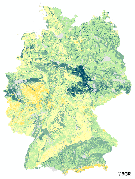
Available water capacity in the rooting zone of German soils
The map of the available water holding capacity in Germany gives an overview of the amount of water in a soil that is normally available for plant growth. The map shows the available water from the surface to effective rooting depth, which is derived from land use and soli data. The method is published in the Bodenkundliche Kartieranleitung KA4 (1994) and in the documentation of Ad-hoc-AG Boden (representing the soil experts of the geological services of the German federal states). The land use information is taken from the CORINE Land Cover data set (2006).
Simple
- Alternate title
-
NFKWe1000_250
- Date (Creation)
- 2014-06-20
- Date (Publication)
- 2015-08-03
- Edition
-
Version 1.0
- Citation identifier
- 0b25c1a6-61c0-4674-a332-3c52cf7d282c
- Status
- Completed
-
GEMET - Concepts, version 2.4
-
-
Boden
-
Bodenkarte
-
Bodenwasser
-
Bodenwasserhaushalt
-
-
GEMET - INSPIRE themes, version 1.0
-
-
Boden
-
Soil
-
-
SGD-Liste
-
-
effektive Durchwurzelungstiefe
-
-
Freies Schlagwort
-
-
nutzbare Feldkapazität
-
Wasserspeicherfähigkeit
-
Wasserkapazität
-
inspireidentifiziert
-
opendata
-
- Place
-
-
Bundesrepublik Deutschland
-
-
Spatial scope
-
-
National
-
-
High-value dataset categories
-
-
Erdbeobachtung und Umwelt
-
- Access constraints
- Other restrictions
- Other constraints
- Es gelten keine Zugriffsbeschränkungen
- Use constraints
- Other restrictions
- Other constraints
-
Allgemeine Geschäftsbedingungen, siehe https://www.bgr.bund.de/AGB - General terms and conditions, see https://www.bgr.bund.de/AGB_en . Die bereitgestellten Informationen sind bei Weiterverwendung wie folgt zu zitieren: Datenquelle: NFKWe1000_250 V1.0, (c) BGR, Hannover, 2015.
- Other constraints
-
Dieser Datensatz kann gemäß der "Nutzungsbestimmungen für die Bereitstellung von Geodaten des Bundes" ( https://sg.geodatenzentrum.de/web_public/gdz/lizenz/geonutzv.pdf ) genutzt werden.
- Other constraints
-
{"id": "geoNutz/20130319", "name": "Nutzungsbestimmungen für die Bereitstellung von Geodaten des Bundes", "url": " https://sg.geodatenzentrum.de/web_public/gdz/lizenz/geonutzv.pdf ", "quelle": "NFKWe1000_250 V1.0, (c) BGR, Hannover, 2015"}
- Spatial representation type
- Grid
- Denominator
- 1000000
- Language
- Deutsch
- Character set
- UTF8
- Topic category
-
- Geoscientific information
))
- Geographic identifier
- Regionalschlüssel / 000000000000
- Unique resource identifier
- EPSG:3034
- Distribution format
-
-
georef. TIFF
(
n/a
)
-
georef. TIFF
(
n/a
)
- Transfer size
- 5
- OnLine resource
-
NFKWe1000_250 (georef. TIFF)
NFKWe1000_250 im Format georeferenziertes TIFF
- OnLine resource
- Website zum Thema
- OnLine resource
- Karte im BGR-Geoviewer
- Hierarchy level
- Dataset
Conformance result
- Date (Publication)
- 2010-12-08
- Explanation
-
siehe dazu die angegebene Durchführungsbestimmung
- Statement
-
Bodendaten aus BÜK1000N V2.31 (BGR), Landnutzungsdaten aus Corine Land Cover 2006 (UBA/DLR).
- File identifier
- 8e3f001c-9c6e-4eeb-8d0d-988456a20486 XML
- Metadata language
- Deutsch
- Character set
- UTF8
- Hierarchy level
- Dataset
- Hierarchy level name
-
Boden
- Date stamp
- 2025-03-12
- Metadata standard name
-
INSPIRE Metadata Implementing Rules: Technical Guidelines based on EN ISO 19115 and EN ISO 19119
- Metadata standard version
-
n/a
Overviews
Spatial extent
Provided by
