 www.geodatenkatalog.de (S3L)
Processed seismic data of Cruise BGR89 MESOC 1989
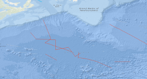
In the time from 13th August to 13th September, 1989 a geophysical survey was carried out with S.V. PROSPEKTA in the Southeastern Newfoundland Basin and in the Sohm Abyssal Plain. Sixteen multichannel seismic lines with a total length of 3,568 km were surveyed. The general aim of the survey was to study the structure of the oceanic crust formed during the period from 150 to 80 m.y.B.P.. The results we found that the magmatic-volcanic activity at the Mesozoic Atlantic spreading center was episodic, and there was some form of magmatic-tectonic cycling in the Mid-Atlantic Ridge processes. Drastic changes of the oceanic crustal structure have been observed, and a volcanic basement unit characterized by an internally divergent pattern of reflection horizons having an eastward dip was found coinciding with magnetic anomalies M-4 to M-0. This body consists probably of basaltic flows and volcanic clastic rocks extruded near or above sea level, and it appears that this unit is continuous from the Eastern Newfoundland Basin to the New England Seamount Chain. A doubling of the oceanic crustal thickness occurs around M-10 and is present in the area of the young end of the series of magnetic M-anomalies. Doubling of the thickness of the oceanic crust is also present in the conjugate eastern central North Atlantic segment in the area of magnetic anomalies M-10 to about M-0.
|
|
Citation proposal
. Processed seismic data of Cruise BGR89 MESOC 1989. https://gdk.gdi-de.org/geonetwork/srv/api/records/8f1b8ee3-ab66-4f01-9199-1aeff1136320 |
Simple
- Alternate title
- BGR89 MESOC 1989
- Date ( Creation )
- 1989-09-13
- Identifier
- 55787628-d2ba-dc1e-6cbf-24e814688b2c
- Status
- completed Completed
Point of contact
- GEMET - INSPIRE themes, version 1.0 ( Theme )
-
- Geologie
- geology
- GEMET - Concepts, version 2.4 ( Theme )
-
- geophysics
- Geophysik
- raw material
- Rohstoff
- Keywords ( Theme )
-
- Marine geology
- Meeresgeologie
- Seismics
- Seismik
- Two-dimensional seismic reflection
- zweidimensionale Reflektionsseismik
- Keywords ( Place )
-
- Northwest Atlantic Ocean
- Newfoundland Basin
- Sohm Abyssal Plain
- Nordwest-Atlantik
- Neufundland-Becken
- Sohm-Tiefsee-Ebene
- Access constraints
- Other restrictions
- Use constraints
- Other restrictions
- Other constraints
- Allgemeine Geschäftsbedingungen, siehe http://www.bgr.bund.de/AGB - General terms and conditions, see http://www.bgr.bund.de/AGB_en. Die bereitgestellten Informationen sind bei Weiterverwendung wie folgt zu zitieren: Datenquelle: BGR89 MESOC 1989, (c) BGR, Hannover, 2018
- Spatial representation type
- Vector
- Metadata language
- English
- Character set
- UTF8
- Topic category
-
- Geoscientific information
N
S
E
W
))
- Distribution format
-
- Shapefile (n/a )
- Transfer size
- 2
- OnLine resource
-
BGR89 MESOC 1989 (Shapefile)
BGR89 MESOC 1989 im Format ESRI Shape
- OnLine resource
-
Profile BGR89-01
Profile BGR89-01
- OnLine resource
-
Profile BGR89-02
Profile BGR89-02
- OnLine resource
-
Profile BGR89-03
Profile BGR89-03
- OnLine resource
-
Profile BGR89-04
Profile BGR89-04
- OnLine resource
-
Profile BGR89-05
Profile BGR89-05
- OnLine resource
-
Profile BGR89-06
Profile BGR89-06
- OnLine resource
-
Profile BGR89-07
Profile BGR89-07
- OnLine resource
-
Profile BGR89-08
Profile BGR89-08
- OnLine resource
-
Profile BGR89-09
Profile BGR89-09
- OnLine resource
-
Profile BGR89-10
Profile BGR89-10
- OnLine resource
-
Profile BGR89-11
Profile BGR89-11
- OnLine resource
-
Profile BGR89-12
Profile BGR89-12
- OnLine resource
-
Profile BGR89-13
Profile BGR89-13
- OnLine resource
-
Profile BGR89-14
Profile BGR89-14
- OnLine resource
-
Profile BGR89-15
Profile BGR89-15
- OnLine resource
-
Profile BGR89-16
Profile BGR89-16
- OnLine resource
-
Karte im BGR-Geoviewer
Karte im BGR-Geoviewer
- Hierarchy level
- Dataset
Conformance result
- Date ( Publication )
- 2010-12-08
- Explanation
- siehe dazu die angegebene Durchführungsbestimmung
- Statement
- During the period from 13th August 1989 to 13th September 1989 BGR acquired seismic lines in the Northwest Atlantic Ocean off Newfoundland. The line BGR89-01 consists of stacked data. The lines BGR89-02 to BGR89-16 are migrated data.
gmd:MD_Metadata
- File identifier
- 8f1b8ee3-ab66-4f01-9199-1aeff1136320 XML
- Metadata language
- English
- Character set
- UTF8
- Parent identifier
- 06a73c56-06a2-40d8-b806-466222b0760d
- Hierarchy level
- Dataset
- Hierarchy level name
- Geophysik
- Date stamp
- 2023-11-14
- Metadata standard name
- INSPIRE Metadata Implementing Rules: Technical Guidelines based on EN ISO 19115 and EN ISO 19119
- Metadata standard version
- n/a
Point of contact
Overviews
Provided by

Views
8f1b8ee3-ab66-4f01-9199-1aeff1136320
Access to the portal
Read here the full details and access to the data.
Associated resources
Not available