 www.geodatenkatalog.de (S1L)
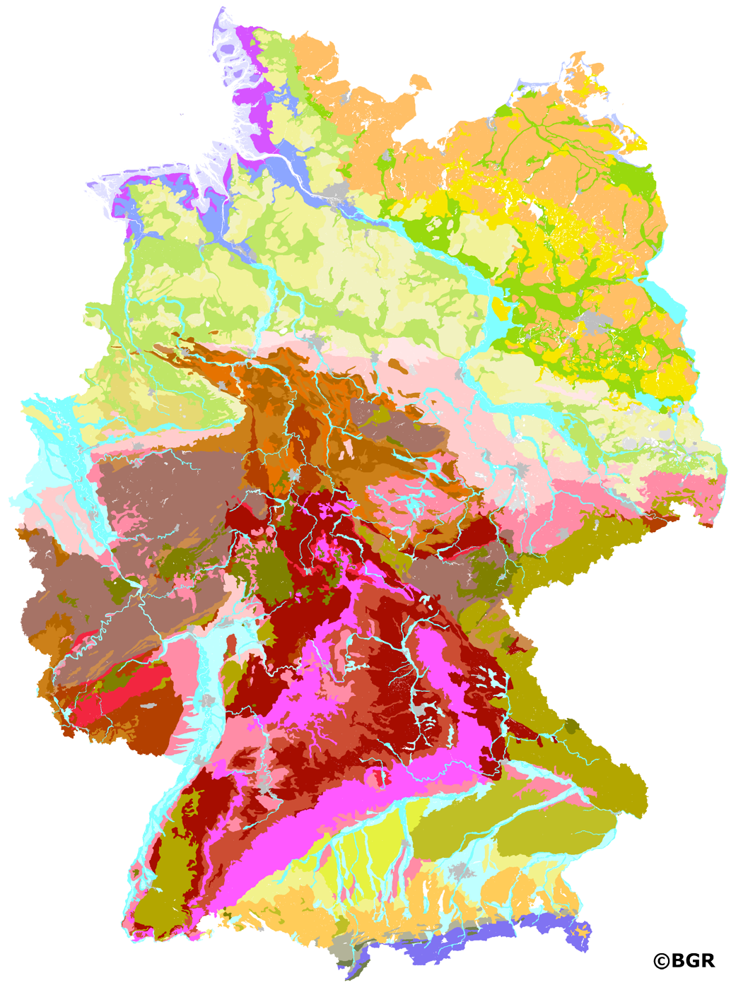
Soil Landscapes of the Federal Republic of Germany 1:250,000
Small-scale soil maps are usually derived from large- or medium-scale soil maps by spatial generalization and content aggregation. A uniform pedoregional classification is required to ensure a comparable approach even across regions. The presented data set at the aggregation level of soil landscapes comprises the 36 most important lithogenetic units in Germany relevant to soil science and is essentially based on the Soil Map 1:200,000 (BUEK200) published jointly by the Federal Institute for Geosciences and Natural Resources (BGR) in cooperation with the National Geological Surveys (SGD) of the federal states and its soil landscape classification. Additionally included are the soils of larger settlement, industrial and commercial areas (as BGL 13.1) and the soils of post-mining landscapes (as BGL 13.2). More detailed information on the soil regions and soil landscapes of the Federal Republic of Germany can be found in the Soil Mapping Guide (KA5), chapter 6.5 starting on page 335. The digital map graphics are based on the topographic principles of the Digital Landscape Model 1:250,000 (DLM250) from 2014 of the Federal Agency for Cartography and Geodesy (BKG).
|
|
Citation proposal
(2022) . Soil Landscapes of the Federal Republic of Germany 1:250,000. https://gdk.gdi-de.org/geonetwork/srv/api/records/93f13b9a-b64f-490d-9561-18b51f67bddb |
INSPIRE
Identification
- File identifier
- 93f13b9a-b64f-490d-9561-18b51f67bddb XML
- Hierarchy level
- Dataset
Online resource
Resource identifier
- code
- B9643278-EF08-4520-8949-8D147FA97A80
- Metadata language
- German
- Spatial representation type
- Vector
Encoding
- Format
- Shapefile
- Version
- n/a
Projection
Classification of data and services
- Topic category
-
- Geoscientific information
Classification of data and services
Coupled resource
Coupled resource
Classification of data and services
Coupled resource
Coupled resource
Keywords
- GEMET - INSPIRE themes, version 1.0 ( Theme )
-
- Soil
- Boden
- GEMET - Concepts, version 2.4 ( Theme )
-
- Bodenart
- Bodengestaltung
- Bodenkarte
- Bodenfunktion
- Bodenbelastung
- Bodenfruchtbarkeit
- Bodennutzung
- Bodenbildung
- SGD-Liste ( Theme )
-
- Bodengruppe
- Bodenverbreitung
- Bodeneigenschaften
Other keywords
- Keywords ( Place )
-
- Bundesrepublik Deutschland
- Keywords ( Theme )
-
- Bodensystematik
- Bodeninformationssystem
- Bodenausgangsgestein
- Bodengroßlandschaft
- Bodengesellschaft
- FISBo BGR
- Downloadable Data
Geographic coverage
N
S
E
W
))
Temporal reference
Temporal extent
Temporal extent
- Date ( Creation )
- 2020-09-10
- Date ( Publication )
- 2022-08-05
Quality and validity
- Lineage
- Ursprung sind die Bodengroßlandschaften der einzelnen Blätter der Bodenübersichtskarte 1:200.000 (BÜK200). Eliminierung von Kartenrandverwerfungen, u.a. zwischen den BGL 6.2 und 6.3, den BGL 9.1, 9.2, 9.3 und 9.4, den BGL 8.2/8.4 und 9.4, den BGL 11.1 und 11.2. Im Landesteil Mecklenburg-Vorpommern Einarbeitung von Änderungsvorschlägen des LUNG Mecklenburg-Vorpommern (Frank Idler, 21. September 2021). Verschneidung mit den Gewässerflächen des DLM250 vom BKG (Stand: 2014).
Conformity
Conformity
Conformity
Conformity
Conformity
Conformity
Restrictions on access and use
- Access constraints
- Allgemeine Geschäftsbedingungen, siehe http://www.bgr.bund.de/AGB - General terms and conditions, see http://www.bgr.bund.de/AGB_en. Die bereitgestellten Informationen sind bei Weiterverwendung wie folgt zu zitieren: Datenquelle: BGL250 V1.4, (C) BGR, Hannover, 2022.
Restrictions on access and use
Responsible organization (s)
Contact for the resource
- Organisation name
- Bundesanstalt für Geowissenschaften und Rohstoffe (BGR)
- fis.bo@bgr.de
Responsible organization (s)
Contact for the resource
- Organisation name
- Bundesanstalt für Geowissenschaften und Rohstoffe (BGR)
- fis.bo@bgr.de
Metadata information
Contact for the metadata
- Organisation name
- Bundesanstalt für Geowissenschaften und Rohstoffe (BGR)
- Date stamp
- 2023-08-22
- Metadata language
- German
- Character set
- UTF8
SDS
Conformance class 1: invocable
Access Point URL
Endpoint URL
Technical specification
Conformance class 2: interoperable
Coordinate reference system
Quality of Service
Access constraints
Limitation
Use constraints
Limitation
Responsible custodian
Contact for the resource
Conformance class 3: harmonized
Overviews
Provided by

Views
93f13b9a-b64f-490d-9561-18b51f67bddb
Access to the portal
Read here the full details and access to the data.
Associated resources
Not available