 www.geodatenkatalog.de (S1L)
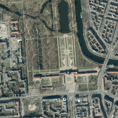
Digitale Orthophotos 2017
Digitale Orthophotos für das gesamte Berliner Stadtgebiet mit einer Bodenauflösung von 0,20 m bzw. 0,10 m im Blattschnitt 2 km x 2 km (1 km x 1 km).
|
|
Citation proposal
(2017) . Digitale Orthophotos 2017. https://gdk.gdi-de.org/geonetwork/srv/api/records/947b53e4-f014-3f12-b7a9-f6438f29223e |
Simple
- Date ( Creation )
- 2017-03-27
- Date ( Publication )
- 2017-07-07
- Presentation form
- Digital map
Point of contact
- Keywords ( Theme )
-
- open data
- opendata
- AdVMIS
- Karten
- Geodaten
- Berlin
- Luftbilder
- Orthophotos
- DOP
- Topographie
- Topografie
- topographisch
- topografisch
- Spatial scope
- Access constraints
- Other restrictions
- Use constraints
- Other restrictions
- Other constraints
- Für die Nutzung der Daten ist die Datenlizenz Deutschland - Zero - Version 2.0 anzuwenden. Die Lizenz ist über https://www.govdata.de/dl-de/zero-2-0 abrufbar.
- Other constraints
- { "id": "dl-zero-de/2.0" , "name": "Datenlizenz Deutschland - Zero - Version 2.0", "url": "https://www.govdata.de/dl-de/zero-2-0" }
- Spatial representation type
- Grid
- Distance
- 0.2 metres
- Distance
- 0.1 metres
- Metadata language
- German
- Character set
- UTF8
- Topic category
-
- Imagery base maps earth cover
N
S
E
W
))
- Extent type code
- true
- Geographic identifier
- 110000000000
- Reference system identifier
- http://www.opengis.net/def/crs/EPSG/0/25833
- Distribution format
-
- Text/HTML (4.01 )
- OnLine resource
-
Darstellungsdienst - Digitale farbige Orthophotos 2017 (DOP20RGB) (WMS)
Darstellungsdienst - Digitale farbige Orthophotos 2017 (DOP20RGB) (WMS)
- OnLine resource
-
Downloaddienst - Digitale farbige Orthophotos 2017 (DOP20RGB) (Atom)
Downloaddienst - Digitale farbige Orthophotos 2017 (DOP20RGB) (Atom)
- Hierarchy level
- Dataset
- Statement
- Daten aus der Berliner Verwaltung
gmd:MD_Metadata
- File identifier
- 947b53e4-f014-3f12-b7a9-f6438f29223e XML
- Metadata language
- German
- Character set
- UTF8
- Hierarchy level
- Dataset
- Date stamp
- 2025-03-06T12:33:42
- Metadata standard name
- ISO 19115/19119 ? BE
- Metadata standard version
- 1.0.0
Overviews
Provided by

Views
947b53e4-f014-3f12-b7a9-f6438f29223e
Access to the portal
Read here the full details and access to the data.
Associated resources
Not available