 www.geodatenkatalog.de (S1L)
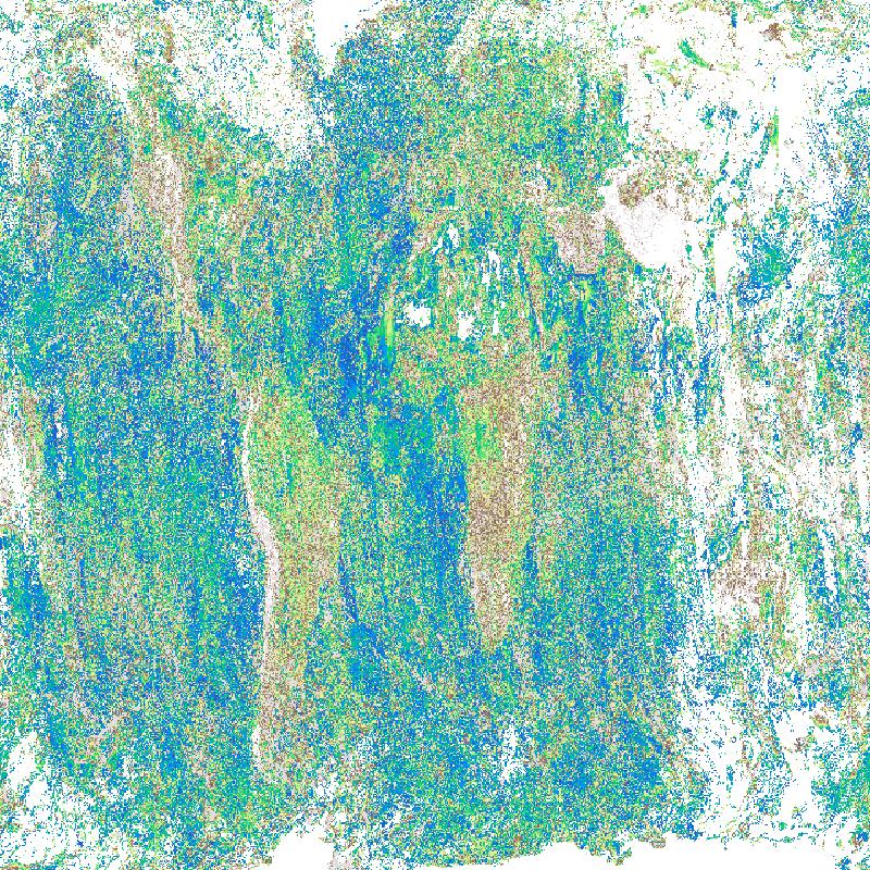
Sentinel-5P TROPOMI – Aerosol Layer Height (ALH), Level 3 – Global
Aerosols are an indicator for episodic aerosol plumes from dust outbreaks, volcanic ash, and biomass burning. Daily observations are binned onto a regular latitude-longitude grid. The Aerosol layer height is provided in kilometres.
The TROPOMI instrument onboard the Copernicus SENTINEL-5 Precursor satellite is a nadir-viewing, imaging spectrometer that provides global measurements of atmospheric properties and constituents on a daily basis. It is contributing to monitoring air quality and climate, providing critical information to services and decision makers.
The instrument uses passive remote sensing techniques by measuring the top of atmosphere solar radiation reflected by and radiated from the earth and its atmosphere. The four spectrometers of TROPOMI cover the ultraviolet (UV), visible (VIS), Near Infra-Red (NIR) and Short Wavelength Infra-Red (SWIR) domains of the electromagnetic spectrum. The operational trace gas products generated at DLR on behave ESA are: Ozone (O3), Nitrogen Dioxide (NO2), Sulfur Dioxide (SO2), Formaldehyde (HCHO), Carbon Monoxide (CO) and Methane (CH4), together with clouds and aerosol properties.
This product is created in the scope of the project INPULS. It develops (a) innovative retrieval algorithms and processors for the generation of value-added products from the atmospheric Copernicus missions Sentinel-5 Precursor, Sentinel-4, and Sentinel-5, (b) cloud-based (re)processing systems, (c) improved data discovery and access technologies as well as server-side analytics for the users, and (d) data visualization services.
|
|
Citation proposal
. Sentinel-5P TROPOMI – Aerosol Layer Height (ALH), Level 3 – Global. https://gdk.gdi-de.org/geonetwork/srv/api/records/96027bd8-8807-4262-a796-3dad1f50deae |
- Identification
- Distribution
- Quality
- Spatial rep.
- Ref. system
- Content
- Portrayal
- Metadata
- Md. constraints
- Md. maintenance
- Schema info
Identification
Data identification
Citation
- Date ( Creation )
- 2025-04-09T10:00:00
- Presentation form
- Digital map
- Status
- ongoing
Point of contact
Distributor
- Maintenance and update frequency
- Daily
- Keywords
-
- DLR
- EOC
- Sentinel-5P
- TROPOMI
- aerosol layer height
- Atmosphere
- Aerosol Layer Height (ALH)
- Daily
- Level 3
- opendata
- GEMET - INSPIRE themes, version 1.0 ( Theme )
- Spatial scope ( Theme )
- Use limitation
- Nutzungseinschränkungen: Das DLR ist nicht haftbar für Schäden, die sich aus der Nutzung ergeben. / Use Limitations: DLR not liable for damage resulting from use.
Legal constraints
- Access constraints
- Other restrictions
Legal constraints
- Use constraints
- Other restrictions
- Other constraints
- Nutzungsbedingungen: Lizenz, https://creativecommons.org/licenses/by/4.0 / Terms of use: License, https://creativecommons.org/licenses/by/4.0
- Other constraints
-
{"id": "cc-by-4.0",
"name": "Creative Commons Namensnennung - 4.0 International (CC BY 4.0)",
"url": "http://dcat-ap.de/def/licenses/cc-by/4.0",
"quelle": "Copyright DLR (Year of download)"}
- Spatial representation type
- Grid
- Denominator
- 2000000
- Metadata language
- German
- Character set
- UTF8
- Topic category
-
- Climatology, meteorology, atmosphere
Extent
))
Distribution
Distribution
- Distribution format
-
- GeoTIFF ()
Digital transfer options
- OnLine resource
-
Atmos - TROPOMI / S5P Webpage
Project Website
- OnLine resource
-
Atmos - TROPOMI / S5P Webpage Calendar
Project Website Quicklook Calendar
- OnLine resource
-
EOC Geoservice Map Context
EOC Geoservice Map Context (s5p:tropomi:l3)
- OnLine resource
-
EOC Download Service
Sentinel-5p Tropomi L3 Download Service - EOC Download Service
- OnLine resource
-
S5P_TROPOMI_L3_P1D_ALH_v2
WMS Access: S5P L3 Aerosol Layer Height (ALH)
- OnLine resource
-
S5P_TROPOMI_L3_P1D_ALH_v2
EOC STAC Collection
- OnLine resource
-
EOC Geoservice Dataset
EOC Geoservice Dataset
Quality
Data quality
- Hierarchy level
- Series
Domain consistency
- Measure identification
- INSPIRE / Conformity_001
Conformance result
Citation
- Date ( Publication )
- 2010-12-08
- Explanation
- See the referenced specification.
- Pass
- true
Lineage
- Statement
- The input data for the L3 product is the Sentinel-5P TROPOMI Level 2 product "L2__NASAER_"
- Description
- Processing: Data aggregation of L2 datasets with UMAS into global equirectangular L3 grids of 0.1 deg resolution based on a nearest neighbour approach, with propagation of retrieved main variables, number of observations, quality assurance and uncertainties.
Metadata
Metadata
- File identifier
- 96027bd8-8807-4262-a796-3dad1f50deae XML
- Metadata language
- English
- Character set
- UTF8
- Hierarchy level
- Series
- Hierarchy level name
- Dataseries
- Date stamp
- 2025-04-09T08:54:05
- Metadata standard name
- 19115-1:2014/19139
- Metadata standard version
- 1.0
Point of contact
Overviews
Provided by
