 My GeoNetwork catalogue
Processed seismic data of Cruise BGR78-2 1978
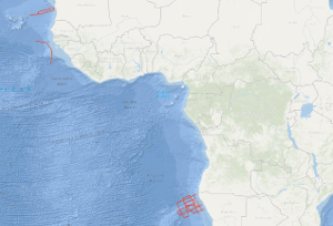
During the second leg of cruise BGR78 from 22th of February to 29th of March 1978 with R/V EXPLORA the following measurements have been carried out as presite- and postsite surveys of DSDP sites: (1) in the region of the eastern Walvis Ridge 4,350 km multichannel seismic reflection profiles, 4,540 km magnetic measurements, 5,000 km gravimetric measurements and sonobuoy refraction measurements on 11 stations (2) on the Guinea Plateau 740 km multichannel seismic reflection profiles in parallel with gravimetric and magnetic measurements (3) between Cape Verde islands and Mauretania 980 km multichannel seismic reflection profiles in parallel with magnetic measurements, 1,480 km gravimetric measurements and sonobuoy refraction measurements on 2 stations. The geophysical measurements show that the structure of the Walvis Ridge is determined by two main tectonic directions (WSW-ENE and SSW-NNE). Presumably the genesis of the fracture zone in the Walvis Ridge area can be traced back to the sea-floor spreading with overprinting effects due to an inhomogeneity in the mantle ("hot spot"). Both DSDP drilling projects in this part of the Walvis Ridge led to a fragmentary knowledge because site 362 got stuck at a depth of 1.100 m in the Oligocene. BGR's measurements indicate a gap of at least 1.000 m of sediments, especially from the cretaceous period, down to the (acoustic) basement. Site 363 at a submarine high has gaps in the depositional sequence and stops at a depth of 700 m shortly above the basement. So for a better understanding of the geologic development of the Walvis Ridge, further DSDP drillings with a recovery of the complete sedimentary sequence and the following basement cores are necessary. Therefore BGR's measurements of this cruise propose new DSDP sites.
Simple
- Alternate title
-
BGR78-2 1978
- Date (Creation)
- 1978-03-29
- Citation identifier
- d0582412-d868-16e2-9833-167140819201
- Status
- Completed
-
GEMET - INSPIRE themes, version 1.0
-
-
Geologie
-
geology
-
-
GEMET - Concepts, version 2.4
-
-
geophysics
-
Geophysik
-
raw material
-
Rohstoff
-
- Theme
-
-
Marine geology
-
Meeresgeologie
-
Seismics
-
Seismik
-
Two-dimensional seismic reflection
-
zweidimensionale Reflektionsseismik
-
- Place
-
-
Walvis Ridge
-
Walvis-Rücken
-
Guinea Plateau
-
Mauretania
-
Mauretanien
-
Southeast Atlantic Ocean
-
Südost-Atlantik
-
- Access constraints
- Other restrictions
- Other constraints
- Es gelten keine Zugriffsbeschränkungen
- Use constraints
- Other restrictions
- Other constraints
-
Allgemeine Geschäftsbedingungen, siehe http://www.bgr.bund.de/AGB - General terms and conditions, see http://www.bgr.bund.de/AGB_en . Die bereitgestellten Informationen sind bei Weiterverwendung wie folgt zu zitieren: Datenquelle: BGR78-2 1978, (c) BGR, Hannover, 2019
- Spatial representation type
- Vector
- Language
- English
- Character set
- UTF8
- Topic category
-
- Geoscientific information
))
- Unique resource identifier
- EPSG:4326
- Distribution format
-
-
Shapefile
(
n/a
)
-
Shapefile
(
n/a
)
- Transfer size
- 1
- OnLine resource
-
BGR78-2 1978 (Shapefile)
BGR78-2 1978 im Format ESRI Shape
- OnLine resource
- Profile BGR78-128
- OnLine resource
- Profile BGR78-129
- OnLine resource
- Profile BGR78-130
- OnLine resource
- Profile BGR78-131
- OnLine resource
- Profile BGR78-132
- OnLine resource
- Profile BGR78-133
- OnLine resource
- Profile BGR78-134
- OnLine resource
- Profile BGR78-134A
- OnLine resource
- Profile BGR78-135
- OnLine resource
- Profile BGR78-136
- OnLine resource
- Profile BGR78-138
- OnLine resource
- Profile BGR78-139
- OnLine resource
- Profile BGR78-140
- OnLine resource
- Profile BGR78-141
- OnLine resource
- Profile BGR78-145
- OnLine resource
- Profile BGR78-146
- OnLine resource
- Profile BGR78-149
- OnLine resource
- Profile BGR78-150
- OnLine resource
- Profile BGR78-151
- OnLine resource
- Karte im BGR-Geoviewer
- Hierarchy level
- Dataset
Conformance result
- Date (Publication)
- 2010-12-08
- Explanation
-
siehe dazu die angegebene Durchführungsbestimmung
- Statement
-
During the period from 22th February to 29th March 1978 BGR acquired seismic lines in the Southeast Atlantic Ocean across the Walvis Ridge and the Guinea Plateau and off Mauretania during the second leg of cruise BGR78. The lines BGR78-127, BGR78-137 and BGR78-148 consist of raw data. The lines BGR78-128, BGR78-129, BGR78-130, BGR78-131, BGR78-132, BGR78-133, BGR78-134, BGR78-134A, BGR78-135, BGR78-136, BGR78-138, BGR78-139, BGR78-140, BGR78-141, BGR78-145, BGR78-146, BGR78-149, BGR78-150 and BGR78-151 are stacked data.
- File identifier
- 96dcdd10-3847-428b-bd2d-b4c93e169b21 XML
- Metadata language
- English
- Character set
- UTF8
- Parent identifier
-
Marine Seismic Survey Profiles (MSSP)
06a73c56-06a2-40d8-b806-466222b0760d
- Hierarchy level
- Dataset
- Hierarchy level name
-
Geophysik
- Date stamp
- 2023-11-14
- Metadata standard name
-
INSPIRE Metadata Implementing Rules: Technical Guidelines based on EN ISO 19115 and EN ISO 19119
- Metadata standard version
-
n/a
Overviews
Spatial extent
Provided by
