 www.geodatenkatalog.de (S3L)
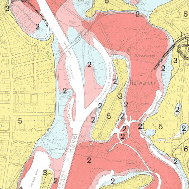
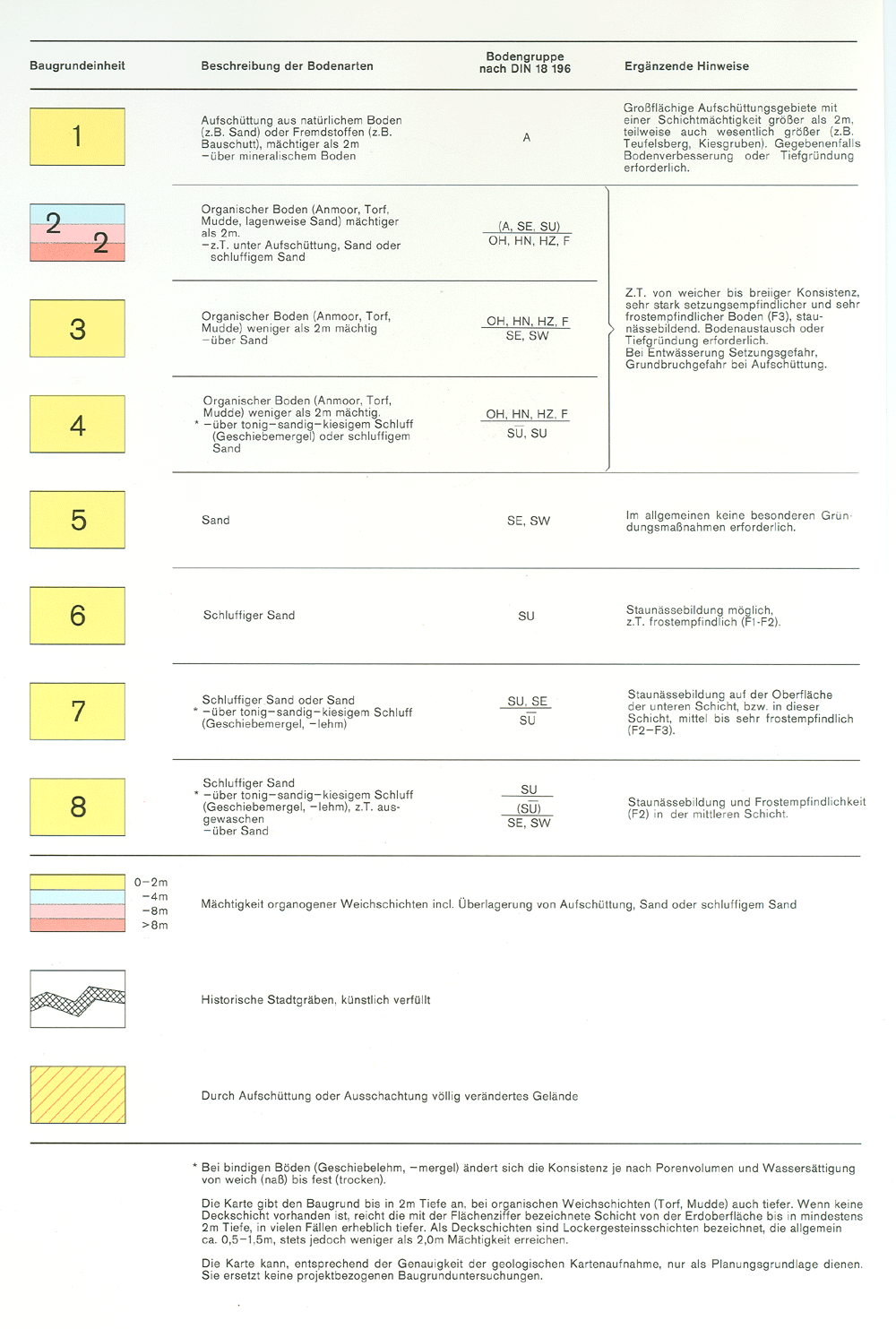
Baugrundkarte (Spandau)
Die Baugrundkarte gibt zur Beurteilung der Tragfähigkeit des Baugrundes einen zusammenfassenden Überblick über Gesteinsarten, Bodengruppen nach DIN 18196 sowie Mächtigkeiten von Weichschichten für Spandau (BGK 10, Blatt 425 und 426).
|
|
Citation proposal
. Baugrundkarte (Spandau). https://gdk.gdi-de.org/geonetwork/srv/api/records/99f6a198-dc72-3385-8cd9-955f1f0de68b |
Simple
Identification info
- Date ( Creation )
- 1991-12-31
- Presentation form
- Digital map
Point of contact
Point of contact
- Maintenance and update frequency
- As needed
- Keywords ( Theme )
-
- open data
- opendata
- Sachdaten
- Karten
- Geodaten
- Berlin
- Tragfähigkeit
- Baugrundkarte
- Baugrundeinheit
- Baugrunduntersuchung
- DIN
- 18196
- Geologische
- Karte
- Räumlicher Anwendungsbereich ( Theme )
- Keywords
-
- infoMapAccessService
- Access constraints
- Other restrictions
- Use constraints
- Other restrictions
- Other constraints
- Für die Nutzung der Daten ist die Datenlizenz Deutschland - Zero - Version 2.0 anzuwenden. Die Lizenz ist über https://www.govdata.de/dl-de/zero-2-0 abrufbar.
- Other constraints
- {"id":"dl-zero-de/2.0","name":"Datenlizenz Deutschland - Zero - Version 2.0","url":"https://www.govdata.de/dl-de/zero-2-0"}
- Service Type
- view
- Service Version
- OGC:WMS 1.0.0
- Service Version
- OGC:WMS 1.1.0
- Service Version
- OGC:WMS 1.1.1
- Service Version
- OGC:WMS 1.3.0
N
S
E
W
))
- Extent type code
- true
- Geographic identifier
- 110000000000
- Coupling Type
- Tight
Contains Operations
- Operation Name
- GetCapabilities
- Distributed Computing Platforms
- Web services
- Connect Point
- https://gdi.berlin.de/services/wms/baugrundkarte_spandau
- Operates On
- Reference system identifier
- http://www.opengis.net/def/crs/EPSG/0/25833
- Distribution format
-
-
Text/HTML
(4.01 )
- Specification
- Keine Angabe
-
Text/HTML
(4.01 )
- OnLine resource
-
Darstellungsdienst - Baugrundkarte (Spandau) (WMS)
Darstellungsdienst - Baugrundkarte (Spandau) (WMS)
- OnLine resource
-
Darstellung der Karte im Geoportal Berlin
Darstellung der Karte im Geoportal Berlin
- Hierarchy level
- Service
- Other
- Dienst
gmd:MD_Metadata
- File identifier
- 99f6a198-dc72-3385-8cd9-955f1f0de68b XML
- Metadata language
- German
- Character set
- UTF8
- Hierarchy level
- Service
- Hierarchy level name
- Baugrundkarte (Spandau) Dienst
- Date stamp
- 2025-11-19T00:00:00Z
- Metadata standard name
- ISO 19115/19119 - BE
- Metadata standard version
- 1.0.0
Point of contact
Overviews
Vorschaubild
Legende
Provided by

Views
99f6a198-dc72-3385-8cd9-955f1f0de68b
Access to the portal
Read here the full details and access to the data.
Associated resources
Not available