 www.geodatenkatalog.de (S3L)
WMS NUTS-Gebiete 1:250 000, Stand 31.12.
Darstellungsdienst der NUTS-Gebiete 1:250 000 mit Stand 31.12.
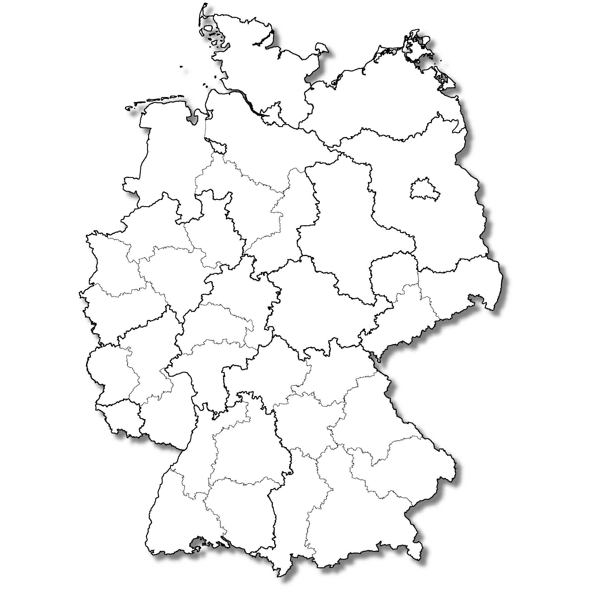
Der Datenbestand umfasst für das Gebiet der Bundesrepublik Deutschland die Regionen der Systematik der Gebietseinheiten (NUTS - Nomenclature des unités territoriales statistiques) für Zwecke der europäischen Statistik.
Die NUTS-Regionen sind hierarchisch strukturiert, gliedern sich in drei Ebenen und orientieren sich für Deutschland mit wenigen Ausnahmen an den Verwaltungseinheiten.
- Ebene NUTS1 in Deutschland: Länder
- Ebene NUTS2 in Deutschland: i. W. Regierungsbezirke
- Ebene NUTS3 in Deutschland: kreisfreie Städte und Landkreise
Auf der NUTS-2-Ebene werden für Deutschland neben den aktuellen Regierungsbezirken auch die ehemaligen Regierungsbezirke der Länder Niedersachsen, Rheinland-Pfalz und Sachsen ausgewiesen. Im nationalen Sprachgebrauch wird diese NUTS-2-Einteilung auch als „Statistische Regionen“ bezeichnet. Die Geometrie ist aus dem jeweiligen Datenbestand der entsprechenden Verwaltungsgebiete (VG) abgeleitet. Somit ist die Geometrie hinsichtlich Genauigkeit und Auflösung analog den Verwaltungsgebieten (VG) auf das entsprechende Digitale Landschaftsmodell (DLM) ausgerichtet.
Die Daten sind ebenenweise (NUTS1, NUTS2 und NUTS3) gegliedert und die enthaltenen Flächen tragen direkt die attributiven Informationen. Maßstab: 1:250000
|
|
Citation proposal
. WMS NUTS-Gebiete 1:250 000, Stand 31.12.. https://gdk.gdi-de.org/geonetwork/srv/api/records/9EEFDB37-301B-4374-9FB0-3E76E7FA8952 |
- Identification
- Distribution
- Quality
- Spatial rep.
- Ref. system
- Content
- Portrayal
- Metadata
- Md. constraints
- Md. maintenance
- Schema info
Identification
Identification info
Service Identification (19119)
Citation
- Alternate title
- wms_nuts250
- Date ( Creation )
- 2018-03-28T00:00:00.000+02:00
- Status
- On going
Point of contact
Resource provider
Maintenance information
- Maintenance and update frequency
- Annually
- Update scope
- Service
- GEMET - Concepts, version 3.1 ( Theme )
- Keywords
-
- INSPIRE:ViewService
- Verwaltungsgebiete
- ViewService
- infoMapAccessService
- su250_1231
- Deutschland
- INSPIRE-WMS_Statistical-Units_NUTS1000
- NUTS-Regionen
- WMS
- Germany
- BKG
- NUTS250
- Service Classification, version 1.0 ( Theme )
-
- infoMapAccessService
Legal constraints
- Access constraints
- otherRestrictions Other restrictions
Legal constraints
- Use constraints
- otherRestrictions Other restrictions
- Other constraints
- Die Daten sind urheberrechtlich geschützt. Die Daten werden geldleistungsfrei gemäß der Datenlizenz Deutschland Namensnennung 2.0 (https://www.govdata.de/dl-de/by-2-0) zur Verfügung gestellt. Die Verwendung des Datensatzes für die Pflege und Erweiterung der Daten des OpenStreetMap Projektes wird unter Einhaltung der im Ergänzungstext beschriebenen Angaben zur Namensnennung ausdrücklich erlaubt, siehe https://sgx.geodatenzentrum.de/web_public/gdz/lizenz/deu/datenlizenz_deutschland_ergaenzungstext_namensnennung.pdf. Der Quellenvermerk ist zu beachten.
- Other constraints
- Quellenvermerk: © BKG (Jahr des Datenbezugs) dl-de/by-2-0, Datenquellen: https://sgx.geodatenzentrum.de/web_public/gdz/datenquellen/datenquellen_vg_nuts.pdf
- Service Type
- view
- Service Version
- OGC:WMS 1.3.0
Extent
Geographic description
- Extent type code
- true
- Geographic identifier
- Bundesrepublik Deutschland
))
Coupled Resource
- Operation Name
- GetCapabilities
Coupled Resource
- Operation Name
- GetMap
Coupled Resource
- Operation Name
- GetFeatureInfo
- Coupling Type
- Tight
Contains Operations
- Operation Name
- GetCapabilities
- Distributed Computing Platforms
- HTTPGet
- Invocation Name
- GetCapabilities
Parameter
- Name
- VERSION=1.3.0
- Description
- Request version
- Optionality
- 1
- Repeatability
- false
- Name
Parameter
- Name
- SERVICE=WMS
- Description
- Service type
- Optionality
- 0
- Repeatability
- false
- Name
Parameter
- Name
- REQUEST=GetCapabilities
- Description
- Request name
- Optionality
- 0
- Repeatability
- false
- Name
Parameter
- Name
- UPDATESEQUENCE=number
- Description
- Sequence number for cache control
- Optionality
- 1
- Repeatability
- false
- Name
- Connect Point
- https://sg.geodatenzentrum.de/wms_nuts250?SERVICE=WMS&
Contains Operations
- Operation Name
- GetMap
- Distributed Computing Platforms
- HTTPGet
- Invocation Name
- GetMap
Parameter
- Name
- FORMAT=output_format
- Description
- Output format of map
- Optionality
- 0
- Repeatability
- false
- Name
Parameter
- Name
- LAYERS=layer_list
- Description
- Comma-separated list of one or more map layers. Optional if SLD parameter is present
- Optionality
- 0
- Repeatability
- false
- Name
Parameter
- Name
- ELEVATION=elevation
- Description
- Elevation of layer desired
- Optionality
- 1
- Repeatability
- false
- Name
Parameter
- Name
- Vendor-specific parameters
- Description
- Optional experimental parameters
- Optionality
- 1
- Repeatability
- false
- Name
Parameter
- Name
- TRANSPARENT=TRUE|FALSE
- Description
- Background transparency of map (default=FALSE)
- Optionality
- 1
- Repeatability
- false
- Name
Parameter
- Name
- WFS=web_feature_service_URL
- Description
- URL of Web Feature Service providing features to be symbolized using SLD
- Optionality
- 1
- Repeatability
- false
- Name
Parameter
- Name
- BBOX=minx,miny,maxx,maxy
- Description
- Bounding box corners (lower left, upper right) in SRS units
- Optionality
- 0
- Repeatability
- false
- Name
Parameter
- Name
- BGCOLOR=color_value
- Description
- Hexadecimal red-green-blue color value for the background color (default=0xFFFFFF)
- Optionality
- 1
- Repeatability
- false
- Name
Parameter
- Name
- TIME=time
- Description
- Time value of layer desired
- Optionality
- 1
- Repeatability
- false
- Name
Parameter
- Name
- REQUEST=GetMap
- Description
- Request name
- Optionality
- 0
- Repeatability
- false
- Name
Parameter
- Name
- WIDTH=output_width
- Description
- Width in pixels of map picture
- Optionality
- 0
- Repeatability
- false
- Name
Parameter
- Name
- SLD=styled_layer_descriptor_URL
- Description
- URL of Styled Layer Descriptor (as defined in SLD Specification)
- Optionality
- 1
- Repeatability
- false
- Name
Parameter
- Name
- STYLES=style_list
- Description
- Comma-separated list of one rendering style per requested layer. Optional if SLD parameter is present
- Optionality
- 0
- Repeatability
- false
- Name
Parameter
- Name
- Other sample dimension(s)
- Description
- Value of other dimensions as appropriate
- Optionality
- 1
- Repeatability
- false
- Name
Parameter
- Name
- EXCEPTIONS=exception_format
- Description
- The format in which exceptions are to be reported by the WMS (default=SE_XML)
- Optionality
- 1
- Repeatability
- false
- Name
Parameter
- Name
- HEIGHT=output_height
- Description
- Height in pixels of map picture
- Optionality
- 0
- Repeatability
- false
- Name
Parameter
- Name
- SRS=namespace:identifier
- Description
- Spatial Reference System
- Optionality
- 0
- Repeatability
- false
- Name
Parameter
- Name
- VERSION=1.3.0
- Description
- Request version
- Optionality
- 0
- Repeatability
- false
- Name
- Connect Point
- https://sg.geodatenzentrum.de/wms_nuts250?SERVICE=WMS&
Contains Operations
- Operation Name
- GetFeatureInfo
- Distributed Computing Platforms
- HTTPGet
- Invocation Name
- GetFeatureInfo
Parameter
- Name
- QUERY_LAYERS=layer_list
- Description
- Comma-separated list of one or more layers to be queried
- Optionality
- 0
- Repeatability
- false
- Name
Parameter
- Name
- VERSION=1.3.0
- Description
- Request version
- Optionality
- 0
- Repeatability
- false
- Name
Parameter
- Name
- INFO_FORMAT=output_format
- Description
- Return format of feature information (MIME type)
- Optionality
- 1
- Repeatability
- false
- Name
Parameter
- Name
- EXCEPTIONS=exception_format
- Description
- The format in which exceptions are to be reported by the WMS (default=application/vnd.ogc.se_xml)
- Optionality
- 1
- Repeatability
- false
- Name
Parameter
- Name
- (map_request_copy)
- Description
- Partial copy of the Map request parameters that generated the map for which information is desired
- Optionality
- 0
- Repeatability
- false
- Name
Parameter
- Name
- X=pixel_column
- Description
- X coordinate in pixels of feature (measured from upper left corner=0)
- Optionality
- 0
- Repeatability
- false
- Name
Parameter
- Name
- Y=pixel_row
- Description
- Y coordinate in pixels of feature (measured from upper left corner=0)
- Optionality
- 0
- Repeatability
- false
- Name
Parameter
- Name
- REQUEST=GetFeatureInfo
- Description
- Request name
- Optionality
- 0
- Repeatability
- false
- Name
Parameter
- Name
- FEATURE_COUNT=number
- Description
- Number of features about which to return information (default=1)
- Optionality
- 1
- Repeatability
- false
- Name
Parameter
- Name
- Vendor-specific parameters
- Description
- Optional experimental parameters
- Optionality
- 1
- Repeatability
- false
- Name
- Connect Point
- https://sg.geodatenzentrum.de/wms_nuts250?SERVICE=WMS&
- Operates On
Distribution
Distribution
- Distribution format
-
- PNG ()
- JPEG ()
- GeoTIFF ()
- OnLine resource
- Produktseite des Geodatenzentrums
Ref. system
- Reference system identifier
- CRS 84: CRS 84 / mathematisch
Metadata
Metadata
- File identifier
- 9EEFDB37-301B-4374-9FB0-3E76E7FA8952 XML
- Metadata language
- German
- Character set
- UTF8
- Hierarchy level
- service Service
- Hierarchy level name
- service
- Date stamp
- 2025-06-03
- Metadata standard name
- ISO19119
- Metadata standard version
- 2005/PDAM 1
Point of contact
Overviews
Provided by
