 www.geodatenkatalog.de (S1L)
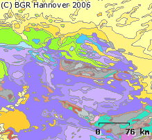
The 1:5 Million International Geological Map of Europe and Adjacent Areas (IGME5000)
The 1:5 Million International Geological Map of Europe and Adjacent Areas shows the pre-Quaternary geology of Europe onshore and offshore. In addition to the geology attributed by age, petrography and genesis, also magnetic anomalies, tectonic structures, metamorphism and – in the offshore areas – information about the continental/oceanic crust and the continental margin, are shown. The map was developed by BGR under the umbrella of the Commission of the Geological Map of the World (CGMW) and in cooperation with geological surveys organisations of 48 countries and more than 20 research institutes. For detailed information about the 'IGME 5000: More than just a map – A multinational GIS Project' please visit the IGME website.
|
|
Citation proposal
(2005) . The 1:5 Million International Geological Map of Europe and Adjacent Areas (IGME5000). https://gdk.gdi-de.org/geonetwork/srv/api/records/9FD6624C-0AA7-46D4-9DA3-955E558CD5F1 |
- Identification
- Distribution
- Quality
- Spatial rep.
- Ref. system
- Content
- Portrayal
- Metadata
- Md. constraints
- Md. maintenance
- Schema info
Identification
Data identification
Citation
- Alternate title
- IGME5000
- Date ( Publication )
- 2005-11-21
- Edition
- 1. Auflage
- Identifier
- 2AA264D3-CB08-4BEC-83F3-996ED3D8A314
- Identifier
- https://doi.org/10.25928/igme-5000
Author
- Other citation details
- Größe der gedruckten Karte: 168,0 x 127,0 cm - Size of printed map: 168.0 x 127.0 cm
- Status
- completed Completed
Point of contact
Bundesanstalt für Geowissenschaften und Rohstoffe
-
Asch, Kristine, Dr.
Stilleweg 2
Hannover
30655
DE
- GEMET - INSPIRE themes, version 1.0 ( Theme )
-
- Geologie
- Geology
- Keywords ( Place )
-
- Europa
- Keywords ( Theme )
-
- EGDI
- igme5000
- GeolDG
- opendata
- High-value dataset categories ( Theme )
-
- Erdbeobachtung und Umwelt
Legal constraints
- Access constraints
- Other restrictions
Legal constraints
- Use constraints
- Other restrictions
- Other constraints
- Allgemeine Geschäftsbedingungen, s. https://www.bgr.bund.de/agb - General Terms and Conditions, s. https://www.bgr.bund.de/agb_en
- Other constraints
- Preis der gedruckten Karte: 18,22 EUR (zzgl. 7% MWSt. und Versandkosten) Weitere Informationen zur Bestellung beim Internationalen Landkartenhaus siehe https://www.bgr.bund.de/produktcenter-bestellhinweis-ILH
- Other constraints
- { "id": "geonutz/20130319", "name": "Nutzungsbestimmungen für die Bereitstellung von Geodaten des Bundes", "url": "https://sg.geodatenzentrum.de/web_public/gdz/lizenz/geonutzv.pdf", "quelle": "IGME5000, BGR" }
- Spatial representation type
- Grid
- Spatial representation type
- Vector
- Denominator
- 5000000
- Metadata language
- eng English
- Character set
- utf8 UTF8
- Topic category
-
- Geoscientific information
N
S
E
W
))
Distribution
Distribution
- Distribution format
-
- PDF (n/a )
- JPEG (n/a )
- TIFF (n/a )
- gedruckt (n/a )
- Shapefile (n/a )
Digital transfer options
- Transfer size
- 4
- OnLine resource
-
IGME5000 (PDF)
IGME5000 im Format Adobe Acrobat Datei (96 dpi)
Digital transfer options
- Transfer size
- 36
- OnLine resource
-
IGME5000 (JPEG)
IGME5000 im Format JPEG (Auflösung 150 dpi)
Digital transfer options
- Transfer size
- 218
- OnLine resource
-
IGME5000 (TIFF)
IGME5000 im Format TIFF (Auflösung 300 dpi)
- OnLine resource
-
IGME5000 (gedruckt)
IGME5000 im Format gedruckt, gefalzt
Digital transfer options
- Transfer size
- 46
- OnLine resource
-
IGME5000 (Shapefile)
IGME5000 im Format ESRI Shape
- OnLine resource
-
Internetseite zur IGME5000 - IGME5000-Website
Internetseite zur IGME5000 - IGME5000-Website
- OnLine resource
-
Ausführliche Beschreibung des Projekts (Sonderheft A 3, Geol. Jahrb.) - Detailed description of the project (Sonderheft A 3, Geol. Jahrb.)
Ausführliche Beschreibung des Projekts (Sonderheft A 3, Geol. Jahrb.) - Detailed description of the project (Sonderheft A 3, Geol. Jahrb.)
- OnLine resource
-
Karte im BGR-Geoviewer
Karte im BGR-Geoviewer
Quality
Data quality
Scope
- Hierarchy level
- Dataset
Conformance result
Citation
- Date ( Publication )
- 2010-12-08
- Explanation
- siehe dazu die angegebene Durchführungsbestimmung
- Statement
- Die Karte entstand unter der Leitung der BGR und der Schirmherrschaft der Weltkartenkommission (CGMW) mit Beiträgen von 48 europäischen geologischen Diensten und mehr als 20 wissenschaftlichen Institutionen. - Manuscripts done by the National Geological Survey Organisations of the involved European countries
Metadata
Metadata
- File identifier
- 9FD6624C-0AA7-46D4-9DA3-955E558CD5F1 XML
- Metadata language
- German
- Character set
- utf8 UTF8
- Hierarchy level
- dataset Dataset
- Hierarchy level name
- Geologie
- Hierarchy level name
- GeolDG
- Date stamp
- 2024-07-18
- Metadata standard name
- INSPIRE Metadata Implementing Rules: Technical Guidelines based on EN ISO 19115 and EN ISO 19119
- Metadata standard version
- n/a
Point of contact
Overviews
Provided by

Views
9FD6624C-0AA7-46D4-9DA3-955E558CD5F1
Access to the portal
Read here the full details and access to the data.
Associated resources
Not available