 www.geodatenkatalog.de (S1L)
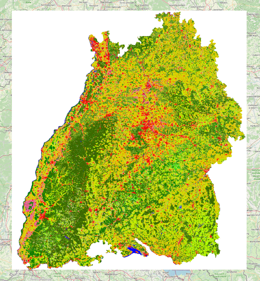
WMTS Landsat 1993
Landnutzungskarte des Landes Baden-Württemberg als Eingabedatensatz für ökologische Bewertungen auf der Grundlage von LANDSAT TM Satellitenbilddaten. Landnutzungskarten in digitaler Form stellen Bezugspunkte für historische und aktuelle Entwicklungen dar und können Grundlage für die Beurteilung von Belastungen und Entwicklungsmöglichkeiten liefern. Die Darstellung dieser aktualisierten Landnutzung erfolgt in Nutzungsklassen, die sowohl als Grundlage für die Abgrenzung von Raumkategorien dienen als auch die Leistungen und Belastungen im Hinblick auf den Naturhaushalt beschreiben. Auflösung: 50 Meter
|
|
Citation proposal
(2022) . WMTS Landsat 1993. https://gdk.gdi-de.org/geonetwork/srv/api/records/9d89677a-ec65-42ef-ad36-1015c260b822 |
INSPIRE
Identification
- File identifier
- 9d89677a-ec65-42ef-ad36-1015c260b822 XML
- Hierarchy level
- service Service
Online resource
Resource identifier
Encoding
Projection
Classification of data and services
Classification of data and services
- Service Type
- view
- Coupling Type
- Tight
Coupled resource
Coupled resource
Classification of data and services
- Service Type
- view
- Coupling Type
- Tight
Coupled resource
Coupled resource
Keywords
- Service Classification, version 1.0 ( Theme )
-
- infoMapAccessService
- Spatial scope
- UMTHES Thesaurus ( Theme )
Other keywords
Geographic coverage
N
S
E
W
))
Temporal reference
Temporal extent
Temporal extent
- Date ( Publication )
- 2022-04-21T00:00:00.000+02:00
Quality and validity
Conformity
Conformity
Conformity
Conformity
Conformity
Conformity
Restrictions on access and use
Restrictions on access and use
Responsible organization (s)
Contact for the resource
- Organisation name
- LUBW Landesanstalt für Umwelt Baden-Württemberg
Responsible organization (s)
Contact for the resource
- Organisation name
- LUBW Landesanstalt für Umwelt Baden-Württemberg
Metadata information
Contact for the metadata
- Organisation name
- LUBW Landesanstalt für Umwelt Baden-Württemberg
- Date stamp
- 2025-04-25
- Metadata language
- German
SDS
Conformance class 1: invocable
Access Point URL
Endpoint URL
Technical specification
Conformance class 2: interoperable
Coordinate reference system
Quality of Service
Access constraints
Limitation
Use constraints
- Use constraints
- Other restrictions
Limitation
Responsible custodian
Contact for the resource
Conformance class 3: harmonized
Contains Operations
- Operation Name
- GetCapabilities
- Distributed Computing Platforms
- Web services
- Operation Description
- Liefert Meta-Informationen zu einem Service, wie z.B.<br>Adresse des Herausgebers, verfügbare Operationen,<br>Eigenschaften der Kartenlayer, unterstützte<br>Raumbezugssystem u.a.
Overviews
Provided by

Views
9d89677a-ec65-42ef-ad36-1015c260b822
Access to the portal
Read here the full details and access to the data.
Associated resources
Not available