 www.geodatenkatalog.de (S3L)
WMTS Digitale Orthophotos - Bodenauflösung 20 cm
Der Dienst stellt die Digitalen Orthophotos in 20 cm Bodenauflösung für das Gebiet der Bundesrepublik Deutschland bereit. Bodenauflösung: 0.2m
|
|
Citation proposal
. WMTS Digitale Orthophotos - Bodenauflösung 20 cm. https://gdk.gdi-de.org/geonetwork/srv/api/records/A3A145DE-2B1B-4EBA-9D09-8F5D72ED4F7D |
INSPIRE
Identification
- File identifier
- A3A145DE-2B1B-4EBA-9D09-8F5D72ED4F7D XML
- Hierarchy level
- service Service
Online resource
Resource identifier
Encoding
- Format
- JPEG
- Format
- PNG
Projection
Classification of data and services
Classification of data and services
- Service Type
- view
- Coupling Type
- Tight
Coupled resource
Coupled resource
Classification of data and services
- Service Type
- view
- Coupling Type
- Tight
Coupled resource
Coupled resource
Keywords
- GEMET - Concepts, version 3.1 ( Theme )
- Service Classification, version 1.0 ( Theme )
-
- infoMapAccessService
Other keywords
- Keywords
-
- WMS
- ViewService
- INSPIRE:ViewSevice
- DOP
- Digitale
- Orthophotos
- Hintergrundkarte
- Digitale Orthophotos
Geographic coverage
N
S
E
W
))
Temporal reference
Temporal extent
Temporal extent
- Date ( Creation )
- 2011-11-29T00:00:00.000+01:00
Quality and validity
Conformity
Conformity
Conformity
Conformity
Conformity
Conformity
Restrictions on access and use
Restrictions on access and use
- Access constraints
- Es gelten Zugriffsbeschränkungen. Für den Erwerb von Nutzungsrechten wenden Sie sich deshalb bitte an die Zentrale Stelle Geotopographie der AdV (ZSGT) / Dienstleistungszentrum (DLZ) des Bundesamtes für Kartographie und Geodäsie: https://www.bkg.bund.de/DE/Service/Kontakt/kontakt.html.
- Access constraints
- Die Daten sind urheberrechtlich geschützt. Die Daten werden Nutzungsberechtigten nach V GeoBund und V GeoLänder geldleistungsfrei sowie Dritten gemäß V ZSGT gegen Gebühren zur Verfügung gestellt. Bitte informieren Sie sich unter nachfolgendem Link über die Details zu Nutzungsbedingungen und Quellenvermerk: https://gdz.bkg.bund.de/index.php/default/hinweise-zu-nutzungsbedingungen-und-quellenvermerken. Der Quellenvermerk ist zu beachten.
- Access constraints
- Quellenvermerk: © GeoBasis-DE / BKG (Jahr)
Responsible organization (s)
Contact for the resource
- Organisation name
- Bundesamt für Kartographie und Geodäsie (BKG)
- dlz@bkg.bund.de
- Organisation name
- Bundesamt für Kartographie und Geodäsie (BKG)
- mailbox@bkg.bund.de
Responsible organization (s)
Contact for the resource
- Organisation name
- Bundesamt für Kartographie und Geodäsie (BKG)
- dlz@bkg.bund.de
- Organisation name
- Bundesamt für Kartographie und Geodäsie (BKG)
- mailbox@bkg.bund.de
Metadata information
Contact for the metadata
- Organisation name
- Bundesamt für Kartographie und Geodäsie (BKG)
- dlz@bkg.bund.de
- Date stamp
- 2025-03-10
- Metadata language
- German
SDS
Conformance class 1: invocable
Access Point URL
Endpoint URL
Technical specification
Conformance class 2: interoperable
Coordinate reference system
Quality of Service
Access constraints
Limitation
- string
- Es gelten Zugriffsbeschränkungen. Für den Erwerb von Nutzungsrechten wenden Sie sich deshalb bitte an die Zentrale Stelle Geotopographie der AdV (ZSGT) / Dienstleistungszentrum (DLZ) des Bundesamtes für Kartographie und Geodäsie: https://www.bkg.bund.de/DE/Service/Kontakt/kontakt.html.
Use constraints
Limitation
- string
- Die Daten sind urheberrechtlich geschützt. Die Daten werden Nutzungsberechtigten nach V GeoBund und V GeoLänder geldleistungsfrei sowie Dritten gemäß V ZSGT gegen Gebühren zur Verfügung gestellt. Bitte informieren Sie sich unter nachfolgendem Link über die Details zu Nutzungsbedingungen und Quellenvermerk: https://gdz.bkg.bund.de/index.php/default/hinweise-zu-nutzungsbedingungen-und-quellenvermerken. Der Quellenvermerk ist zu beachten.
- string
- Quellenvermerk: © GeoBasis-DE / BKG (Jahr)
Responsible custodian
Contact for the resource
Conformance class 3: harmonized
Contains Operations
- Operation Name
- GetCapabilities
- Distributed Computing Platforms
- HTTPGet
- Invocation Name
- GetCapabilities
Parameter
- Name
- ACCEPTVERSIONS=1.0.0,0.8.3
- Description
- Comma-separated prioritized sequence of one or more specification versions accepted by client, with preferred versions listed first
- Optionality
- 1
- Repeatability
- false
- Name
Parameter
- Name
- SERVICE=WMTS
- Description
- Service type
- Optionality
- 0
- Repeatability
- false
- Name
Parameter
- Name
- REQUEST=GetCapabilities
- Description
- Name of request
- Optionality
- 0
- Repeatability
- false
- Name
Parameter
- Name
- ACCEPTFORMATS= text/xml
- Description
- Comma-separated prioritized sequence of zero or more response formats desired by client, with preferred formats listed first
- Optionality
- 1
- Repeatability
- false
- Name
Parameter
- Name
- SECTIONS=Contents
- Description
- Comma-separated unordered list of zero or more names of sections of service metadata document to be returned in service metadata document
- Optionality
- 1
- Repeatability
- false
- Name
Parameter
- Name
- UPDATESEQUENCE=XXX (where XXX is character string previously provided by server)
- Description
- Service metadata document version, value is "increased" whenever any change is made in complete service metadata document
- Optionality
- 1
- Repeatability
- false
- Name
- Connect Point
- https://sg.geodatenzentrum.de/wmts_dop?
Contains Operations
- Operation Name
- GetTile
- Distributed Computing Platforms
- HTTPGet
- Invocation Name
- GetTile
Parameter
- Name
- TileRow=X
- Description
- The Row location of the tile in the defined tileMatrixSet. The value must be in the valid range provided in the capabilities response.
- Optionality
- 1
- Repeatability
- false
- Name
Parameter
- Name
- SERVICE=WMTS
- Description
- Service type
- Optionality
- 0
- Repeatability
- false
- Name
Parameter
- Name
- REQUEST=GetTile
- Description
- Name of request
- Optionality
- 0
- Repeatability
- false
- Name
Parameter
- Name
- TileMatrix=EPSG:3857
- Description
- The Tile Matrix identifier of the tileMatrix in the tileMatrixSet requested that has the desired scale denominator that you want to request. 4326 is WGS84, that is, uses latitude/longitude, while 3857 provides tiles in the spherical mercator projection
- Optionality
- 1
- Repeatability
- false
- Name
Parameter
- Name
- Format=image/png
- Description
- The tile format to return.
- Optionality
- 1
- Repeatability
- false
- Name
Parameter
- Name
- TileCol=Y
- Description
- The Column location of the tile in the defined tileMatrixSet. The value must be in the valid range provided in the capabilities response.
- Optionality
- 1
- Repeatability
- false
- Name
Parameter
- Name
- VERSION=1.0.0
- Description
- Optionality
- 1
- Repeatability
- false
- Name
Parameter
- Name
- Style=default
- Description
- Some layers can be rendered in different ways; check the capabilities document for allowed values on a layer-by-layer basis.
- Optionality
- 1
- Repeatability
- false
- Name
Parameter
- Name
- Layer
- Description
- The layers available from the Online Catalogs; if more than one layer is requested they are in a comma-separated list. Available layers are advertised in the GetCapabilities response.
- Optionality
- 1
- Repeatability
- false
- Name
Parameter
- Name
- TileMatrixSet=EPSG:3857
- Description
- The Tile Matrix Set to be used to generate the response
- Optionality
- 1
- Repeatability
- false
- Name
- Connect Point
- https://sg.geodatenzentrum.de/wmts_dop/tile/1.0.0/
- Connect Point
- https://sg.geodatenzentrum.de/wmts_dop?
Overviews
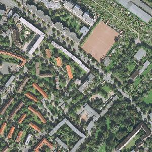
beispielhafter Ausschnitt
Provided by

Views
A3A145DE-2B1B-4EBA-9D09-8F5D72ED4F7D
Access to the portal
Read here the full details and access to the data.
Associated resources
Not available