 www.geodatenkatalog.de (S3L)
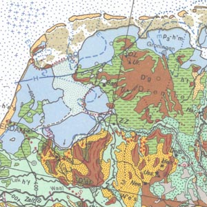
International Quaternary Map of Europe 1:2,500,000
The idea to represent the main features of the European Quaternary was first discussed at the Second Congress of the International Union for Quaternary Research (INQUA) held in Leningrad (St. Petersburg) in 1932. Compiled by the Federal Institute for Geosciences and Natural Resources (BGR) in cooperation with the INQUA, the International Quaternary Map of Europe 1 : 2.500.000 was finished in 1995. It is jointly published by the BGR and UNESCO. Several Quaternary features such as end moraines, ground moraine hillocks, kames, drumlins, eskers and ice border lines are represented on the map. Additionally, the map shows the directions of ice movements, limits of marine transgressions and tectonic faults. Important localities of Quaternary discovery relating to both geology and prehistory, bathymetric lines and recent deposits covering the sea floor are also indicated as well. The legend on each of the 14 map sheets is in German and, depending on the territories covered, in English, French or Russian. The general legend is placed on map sheet number 15.
|
|
Citation proposal
(1995) . International Quaternary Map of Europe 1:2,500,000. https://gdk.gdi-de.org/geonetwork/srv/api/records/A594DD7B-2BE7-4502-8308-AB8DAAD99EB2 |
INSPIRE
Identification
- File identifier
- A594DD7B-2BE7-4502-8308-AB8DAAD99EB2 XML
- Hierarchy level
- series Series
Online resource
Resource identifier
- code
- 3DA64DD9-1A6E-4359-8112-2CA9965F8ECE
- Metadata language
- eng English
- Spatial representation type
- Grid
Encoding
- Format
- Version
- n/a
- Format
- jpg
- Version
- n/a
- Format
- tiff
- Version
- n/a
- Format
- geotiff
- Version
- n/a
Projection
Classification of data and services
- Topic category
-
- Geoscientific information
Classification of data and services
Coupled resource
Coupled resource
Classification of data and services
Coupled resource
Coupled resource
Keywords
- GEMET - INSPIRE themes, version 1.0 ( Theme )
-
- Geologie
- Geology
- GEMET - Concepts, version 2.4 ( Theme )
-
- Tectonic
- Tektonik
Other keywords
- Keywords ( Theme )
-
- archäologische Fundstelle
- Bathymetrie
- Eisrandlage
- Eisscheide
- Endmoräne
- Genese
- Gletscher
- Grundmoräne
- Meeresbodenbedeckung
- Paläolithisch
- Petrographie
- Quartär
- Sedimentverteilung
- Torf
- Transgressionen
- Treibeisgrenze
- Vereisungsphasen
- Vulkan
- Keywords ( Place )
-
- Europa
Geographic coverage
N
S
E
W
))
Temporal reference
Temporal extent
Temporal extent
- Date ( Publication )
- 1995-09-30
Quality and validity
- Lineage
- -
- Denominator
- 2500000
Conformity
Conformity
Conformity
Conformity
Conformity
Conformity
Restrictions on access and use
- Access constraints
- Allgemeine Geschäftsbedingungen, s. https://www.bgr.bund.de/agb - General Terms and Conditions, s. https://www.bgr.bund.de/agb_en
Restrictions on access and use
Responsible organization (s)
Contact for the resource
- Organisation name
- Bundesanstalt für Geowissenschaften und Rohstoffe
- geologie.daten@bgr.de
Responsible organization (s)
Contact for the resource
- Organisation name
- Bundesanstalt für Geowissenschaften und Rohstoffe
- geologie.daten@bgr.de
Metadata information
Contact for the metadata
- Organisation name
- Bundesanstalt für Geowissenschaften und Rohstoffe (BGR)
- Date stamp
- 2025-10-17
- Metadata language
- German
- Character set
- utf8 UTF8
SDS
Conformance class 1: invocable
Access Point URL
Endpoint URL
Technical specification
Conformance class 2: interoperable
Coordinate reference system
Quality of Service
Access constraints
Limitation
Use constraints
Limitation
Responsible custodian
Contact for the resource
Conformance class 3: harmonized
Overviews
Provided by

Views
A594DD7B-2BE7-4502-8308-AB8DAAD99EB2
Access to the portal
Read here the full details and access to the data.
Associated resources
Not available