 www.geodatenkatalog.de (S1L)
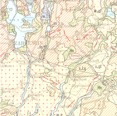
General Geological Map of Germany 1:200,000 (GUEK200) - CC 3126 Hamburg - Ost
The 'Geological Map 1: 200 000 (GUEK200)' shows the geology of Germany on 55 sheets.
It was created in cooperation between the BGR and the National Geological Surveys of the Federal Republic of Germany and neighboring countries.
The map shows the regional distribution of different geological units and provides information on the rocks in about 2 feet deep.
The information about age, origin and composition of the rocks are used for questions of different disciplines.
Each sheet contains the schematic representation of a section through the subsurface to illustrate the spatial structure of the over-and coexistence of the rocks.
|
|
Citation proposal
(2007) . General Geological Map of Germany 1:200,000 (GUEK200) - CC 3126 Hamburg - Ost. https://gdk.gdi-de.org/geonetwork/srv/api/records/AC209220-4A6C-420C-A1E3-2F3997105B7F |
Simple
- Alternate title
- GÜK200 - CC 3126 Hamburg - Ost
- Date ( Publication )
- 2007-03-12
- Edition
- gescanntes Druckexemplar
- Identifier
- 78352AC7-41F2-43A7-89A4-9DC7B044B4C5
- Other citation details
- Hinweis: PDF, JPG, TIFF sind gescannte Druckausgaben! Größe der gedruckte Karte: 83,2 x 62,3 cm - Note: PDF, JPG, TIFF are based on scanned printed edition! Size of the printed map: 83.2 x 62.3 cm
- Status
- completed Completed
Point of contact
- GEMET - INSPIRE themes, version 1.0 ( Theme )
-
- Geologie
- Geology
- Keywords ( Theme )
-
- Allgemeine Geologie
- Eisrandlagen
- Genese
- Geologische Karte
- Känozoikum
- Kreide
- Mesozoikum
- Paläozoikum
- Perm
- Petrographie
- Quartär
- Rasterdaten
- Salzstock
- Sedimentgestein
- Stratigraphie
- Tertiär
- Trias
- Überlagerungen
- Vektordaten
- Keywords ( Place )
-
- Niedersachsen
- Keywords ( Place )
-
- Hamburg
- Keywords
-
- opendata
- Access constraints
- Other restrictions
- Use constraints
- Other restrictions
- Other constraints
- Allgemeine Geschäftsbedingungen, s. https://www.bgr.bund.de/agb - General Terms and Conditions, s. https://www.bgr.bund.de/agb_en
- Other constraints
- Dieser Datensatz kann gemäß der "Nutzungsbestimmungen für die Bereitstellung von Geodaten des Bundes" (https://sg.geodatenzentrum.de/web_public/gdz/lizenz/geonutzv.pdf) genutzt werden.
- Other constraints
- Preis der gedruckten Karte: 14,02 EUR (zzgl. 7% MWSt. und Versandkosten) Weitere Informationen zur Bestellung beim Internationalen Landkartenhaus siehe https://www.bgr.bund.de/produktcenter-bestellhinweis-ILH
- Other constraints
- {"id": "geoNutz/20130319", "name": "Nutzungsbestimmungen für die Bereitstellung von Geodaten des Bundes", "url": "https://sg.geodatenzentrum.de/web_public/gdz/lizenz/geonutzv.pdf", "quelle": "Bundesanstalt für Geowissenschaften und Rohstoffe (BGR)"}
- Spatial representation type
- Grid
- Spatial representation type
- Vector
- Denominator
- 200000
- Metadata language
- ger German
- Character set
- utf8 UTF8
- Topic category
-
- Geoscientific information
))
- Distribution format
-
- PDF (n/a )
- Shapefile (n/a )
- JPEG (n/a )
- TIFF (n/a )
- gedruckt (n/a )
- georef. TIFF (n/a )
- Transfer size
- 52
- OnLine resource
-
GÜK200 - CC 3126 Hamburg - Ost (PDF)
GÜK200 - CC 3126 Hamburg - Ost im Format Adobe Acrobat Datei (Auflösung 300 dpi)
- Transfer size
- 4
- OnLine resource
-
GÜK200 - CC 3126 Hamburg - Ost (Shapefile)
GÜK200 - CC 3126 Hamburg - Ost im Format ESRI Shape
- Transfer size
- 5
- OnLine resource
-
GÜK200 - CC 3126 Hamburg - Ost (JPEG)
GÜK200 - CC 3126 Hamburg - Ost im Format JPEG (Auflösung 150 dpi)
- Transfer size
- 152
- OnLine resource
-
GÜK200 - CC 3126 Hamburg - Ost (TIFF)
GÜK200 - CC 3126 Hamburg - Ost im Format TIFF (Auflösung 300 dpi)
- OnLine resource
-
GÜK200 - CC 3126 Hamburg - Ost (gedruckt)
GÜK200 - CC 3126 Hamburg - Ost im Format gedruckt, gefalzt
- Transfer size
- 185
- OnLine resource
-
GÜK200 - CC 3126 Hamburg - Ost (georef. TIFF)
GÜK200 - CC 3126 Hamburg - Ost im Format georeferenziertes TIFF
- OnLine resource
-
Indexkarte
Indexkarte
- Hierarchy level
- Dataset
- Statement
- -
gmd:MD_Metadata
- File identifier
- AC209220-4A6C-420C-A1E3-2F3997105B7F XML
- Metadata language
- German
- Character set
- utf8 UTF8
- Parent identifier
- ABA9633F-E0BA-438D-918C-6B3BEB4D641C
- Hierarchy level
- dataset Dataset
- Hierarchy level name
- Geologie
- Date stamp
- 2022-08-17
- Metadata standard name
- INSPIRE Metadata Implementing Rules: Technical Guidelines based on EN ISO 19115 and EN ISO 19119
- Metadata standard version
- n/a
Point of contact
Overviews
Provided by
