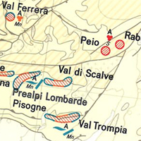
International Map of the Iron Ore Deposits of Europe 1:2,500,000 - Sheet 14 Tunis
The International Map of the Iron Ore Deposits of Europe 1 : 2.500.000 completed in 1977 is published by the Federal Institute for Geosciences and Natural Resources (BGR) About 70 geoscientists from Europe, North Africa, Eastern Europe and Middle East collaborated with the Editorial Staff in the compilation of the map and the Editorial Notes. More than 800 iron ore deposits are represented on the map which covers 42 countries in 16 map sheets. All deposits of importance, either actually being mined or recently abandoned, are included. Deposits of only genetic or historic interest are also shown. Detailed information on the Map of Iron Ore Deposits of Europe - to its structure, arrangement and background data - can be found in the Explanatory Notes to the Map
|
|
Citation proposal
(1977) . International Map of the Iron Ore Deposits of Europe 1:2,500,000 - Sheet 14 Tunis. https://gdk.gdi-de.org/geonetwork/srv/api/records/B9B7B25A-9D1F-4BC6-B782-69626F3C1C09 |
Simple
- Alternate title
- CIGFE2500 - Blatt 14 Tunis
- Date ( Publication )
- 1977-09-28
- Edition
- 1. Auflage
- Identifier
- D5DF2147-C454-4074-80C5-6BABFB13C542
Author
- Other citation details
- Größe der gedruckten Karte: 96,0 x 63,0 cm - Size of printed map: 96.0 x 63.0 cm
- Status
- completed Completed
Point of contact
Bundesanstalt für Geowissenschaften und Rohstoffe
-
Asch, Kristine, Dr.
Stilleweg 2
Hannover
30655
DE
- GEMET - INSPIRE themes, version 1.0 ( Theme )
-
- Geologie
- Geology
- GEMET - Concepts, version 2.4 ( Theme )
-
- tectonic
- Tektonik
- Keywords ( Theme )
-
- deposits
- Lagerstätten
- Lithologie
- lithology
- mineralisation
- Mineralisierung
- Keywords ( Place )
-
- Algerien
- Keywords ( Place )
-
- Tunesien
- Keywords ( Place )
-
- Libyen
- Keywords ( Place )
-
- Malta
- Keywords ( Place )
-
- Italien
- Access constraints
- Other restrictions
- Use constraints
- Other restrictions
- Other constraints
- Allgemeine Geschäftsbedingungen, s. https://www.bgr.bund.de/agb - General Terms and Conditions, s. https://www.bgr.bund.de/agb_en
- Other constraints
- Preis der gedruckten Karte: 14,02 EUR (zzgl. 7% MWSt. und Versandkosten) Weitere Informationen zur Bestellung beim Internationalen Landkartenhaus siehe https://www.bgr.bund.de/produktcenter-bestellhinweis-ILH
- Spatial representation type
- Grid
- Denominator
- 2500000
- Metadata language
- fra fra
- Character set
- utf8 UTF8
- Topic category
-
- Geoscientific information
N
S
E
W
))
- Distribution format
-
- PDF (n/a )
- JPEG (n/a )
- TIFF (n/a )
- gedruckt (n/a )
- Transfer size
- 1
- OnLine resource
-
CIGFE2500 - Blatt 14 Tunis (PDF)
CIGFE2500 - Blatt 14 Tunis im Format Adobe Acrobat Datei (geringe Auflösung)
- Transfer size
- 2
- OnLine resource
-
CIGFE2500 - Blatt 14 Tunis (JPEG)
CIGFE2500 - Blatt 14 Tunis im Format JPEG (Auflösung 150 dpi)
- Transfer size
- 42
- OnLine resource
-
CIGFE2500 - Blatt 14 Tunis (TIFF)
CIGFE2500 - Blatt 14 Tunis im Format TIFF (Auflösung 300 dpi)
- OnLine resource
-
CIGFE2500 - Blatt 14 Tunis (gedruckt)
CIGFE2500 - Blatt 14 Tunis im Format gedruckt, gefalzt
- OnLine resource
-
CIGFE2500-Internetseite - CIGFE2500-Website
CIGFE2500-Internetseite - CIGFE2500-Website
- OnLine resource
-
Indexkarte
Indexkarte
- Hierarchy level
- Dataset
- Statement
- -
gmd:MD_Metadata
- File identifier
- B9B7B25A-9D1F-4BC6-B782-69626F3C1C09 XML
- Metadata language
- German
- Character set
- utf8 UTF8
- Parent identifier
- 3F7938FA-A594-4596-A16A-8FFD2868489F
- Hierarchy level
- dataset Dataset
- Hierarchy level name
- Rohstoffe
- Date stamp
- 2025-03-11
- Metadata standard name
- INSPIRE Metadata Implementing Rules: Technical Guidelines based on EN ISO 19115 and EN ISO 19119
- Metadata standard version
- n/a
Point of contact
Overviews

Provided by

Views
B9B7B25A-9D1F-4BC6-B782-69626F3C1C09
Access to the portal
Read here the full details and access to the data.
Associated resources
Not available
 www.geodatenkatalog.de (S1L)