 My GeoNetwork catalogue
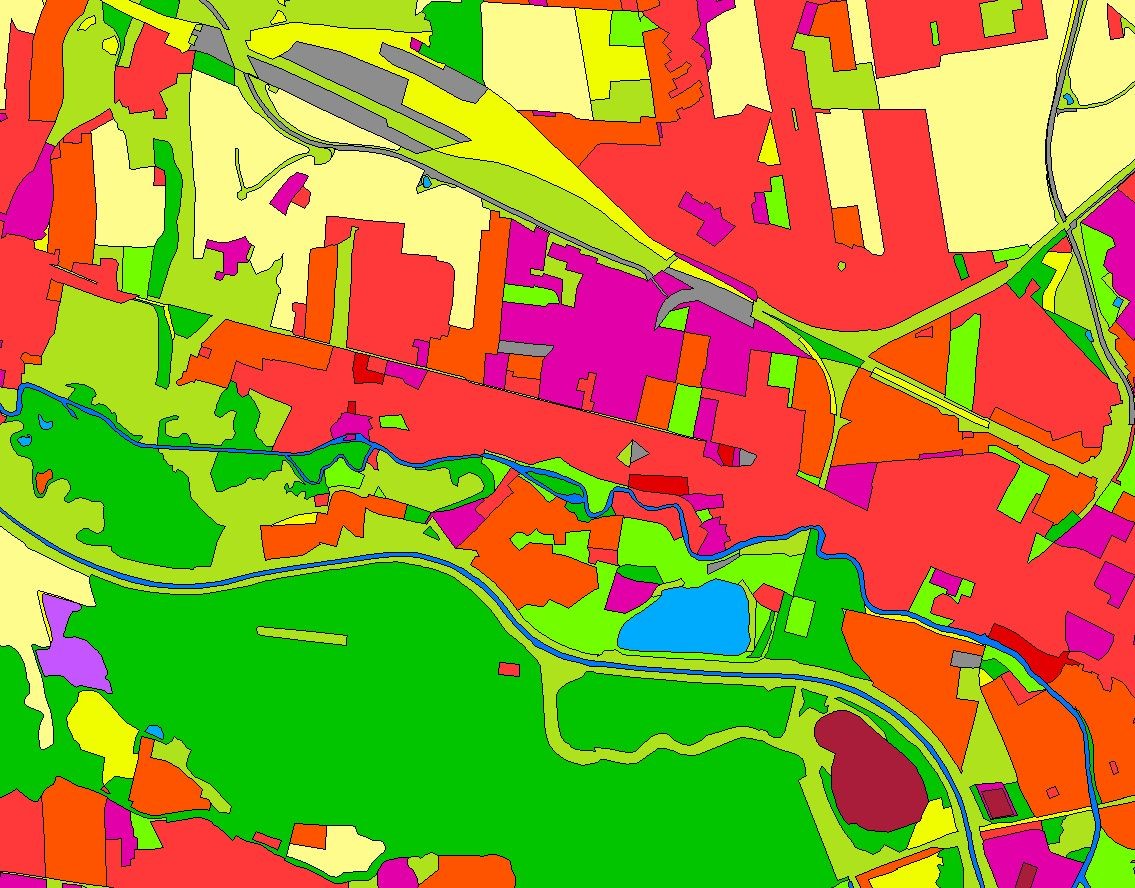
Landbedeckungsmodell für Deutschland (LBM-DE) 2021
Das Landbedeckungsmodell Deutschland (LBM-DE) besitzt eine detaillierte Gliederung in Landbedeckung (LB) und Landnutzung (LN) bei einer Mindestkartierfläche von 1ha. Aus den Kombinationen von LB und LN werden eindeutige CORINE LandCover-Klassen abgeleitet ("CLC").
INSPIRE
Identification
- File identifier
- BBB47E1F-4E6C-4969-844A-14CAF097FD1F XML
- Hierarchy level
- Dataset
Online resource
Resource identifier
- Metadata language
- Deutsch
Encoding
- Format
-
GeoPackage
Classification of data and services
- Topic category
-
- Imagery base maps earth cover
Classification of data and services
Coupled resource
Coupled resource
Classification of data and services
Coupled resource
Coupled resource
Geographic coverage
))
Temporal reference
Temporal extent
- Begin
- 2021-01-01T00:00:00.000+01:00
- End
- 2021-12-31T00:00:00.000+01:00
Temporal extent
- Date (Revision)
- 2026-03-09T00:00:00.000+01:00
Quality and validity
- Lineage
-
Das BKG erstellt und aktualisiert das LBM-DE, welches auf Geobasisdaten aufsetzt und Satellitenbilder zur Aktualisierung nutzt.
- Denominator
- 25000
Conformity
Conformity
Conformity
Conformity
Conformity
Conformity
Restrictions on access and use
- Access constraints
-
Quellenvermerk: © BKG (Jahr des letzten Datenbezugs) CC BY 4.0, Datenquellen: https://sgx.geodatenzentrum.de/web_public/gdz/datenquellen/datenquellen_lbm-de2021.pdf
- Access constraints
-
{"id":"cc-by/4.0","name":"Creative Commons Namensnennung – 4.0 International (CC BY 4.0)","url":" https://creativecommons.org/licenses/by/4.0/","quelle":"© BKG (Jahr des letzten Datenbezugs) CC BY 4.0, Datenquellen: https://sgx.geodatenzentrum.de/web_public/gdz/datenquellen/datenquellen_lbm-de2021.pdf"}
- Access constraints
- Es gelten keine Zugriffsbeschränkungen
Responsible organization (s)
Contact for the resource
- Organisation name
-
Bundesamt für Kartographie und Geodäsie (BKG)
- Organisation name
-
Bundesamt für Kartographie und Geodäsie (BKG)
Responsible organization (s)
Contact for the resource
- Organisation name
-
Bundesamt für Kartographie und Geodäsie (BKG)
- Organisation name
-
Bundesamt für Kartographie und Geodäsie (BKG)
Metadata information
Contact for the metadata
- Organisation name
-
Bundesamt für Kartographie und Geodäsie (BKG)
- Date stamp
- 2026-05-05
- Metadata language
- Deutsch
SDS
Conformance class 1: invocable
Access Point URL
Endpoint URL
Technical specification
Conformance class 2: interoperable
Access constraints
Limitation
Use constraints
Limitation
Responsible custodian
Contact for the resource
Overviews
Spatial extent
Provided by
