 www.geodatenkatalog.de (S1L)
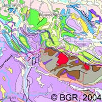
Geoscientific Map of Germany 1:2,000,000 - Geology and Traffic
The series 'Geoscience Map of Germany 1: 2 000 000' contains easily comprehensible maps on various topics. The base map "Geology" shows Germany and the adjacent areas in 30 units, differentiated by the formation age. In addition, areas with igneous and metamorphic (formed by shaping) rocks are reported. 5 different types of lines provide an overview of fracture zones in the subsurface. In addition, the expansions of the last ice age are included. A schematic cross section through the surface from south to north shows the structure of the older basement and its cover by younger rocks. It is available in two versions: one with a simple topography and once, for better orientation, with the network of interstate highways. The map 'Important deposits' shows deposits and mines of energy raw materials, metal materials, industrial minerals and salts based on a simplified, time-structured geology within Germany.
|
|
Citation proposal
(2004) . Geoscientific Map of Germany 1:2,000,000 - Geology and Traffic. https://gdk.gdi-de.org/geonetwork/srv/api/records/C2E19090-875B-4BCC-804B-7FF3F9DFB8CF |
- Identification
- Distribution
- Quality
- Spatial rep.
- Ref. system
- Content
- Portrayal
- Metadata
- Md. constraints
- Md. maintenance
- Schema info
Identification
Data identification
Citation
- Alternate title
- GK2000 Geologie und Verkehr
- Date ( Publication )
- 2004-09-30
- Identifier
- 15D41A40-8083-4431-AE4D-F162F4C100A9
Author
Author
- Status
- completed Completed
Point of contact
Bundesanstalt für Geowissenschaften und Rohstoffe
-
Vinnemann, Christa
Stilleweg 2
Hannover
30655
DE
- GEMET - INSPIRE themes, version 1.0 ( Theme )
-
- Geologie
- Geology
- GEMET - Concepts, version 2.4 ( Theme )
-
- tectonic
- Tektonik
- Keywords ( Theme )
-
- Autobahnnetz
- Eiszeiten
- GK2000
- Stratigraphie
- Keywords ( Place )
-
- Deutschland
Legal constraints
- Access constraints
- Other restrictions
Legal constraints
- Use constraints
- Other restrictions
- Other constraints
- Allgemeine Geschäftsbedingungen, s. https://www.bgr.bund.de/agb - General Terms and Conditions, s. https://www.bgr.bund.de/agb_en
- Spatial representation type
- Grid
- Denominator
- 2000000
- Metadata language
- ger German
- Character set
- utf8 UTF8
- Topic category
-
- Geoscientific information
N
S
E
W
))
- Geographic identifier
- 000000000000
Distribution
Distribution
- Distribution format
-
- PDF (n/a )
Digital transfer options
- Transfer size
- 4
- OnLine resource
-
GK2000 Geologie und Verkehr (PDF)
GK2000 Geologie und Verkehr im Format Adobe Acrobat Datei (Auflösung 300 dpi)
- OnLine resource
-
GK2000-Internetseite - GK2000-Website
GK2000-Internetseite - GK2000-Website
Quality
Data quality
Scope
- Hierarchy level
- Dataset
- Statement
- -
Metadata
Metadata
- File identifier
- C2E19090-875B-4BCC-804B-7FF3F9DFB8CF XML
- Metadata language
- German
- Character set
- utf8 UTF8
- Hierarchy level
- dataset Dataset
- Hierarchy level name
- Geologie
- Date stamp
- 2025-04-23
- Metadata standard name
- INSPIRE Metadata Implementing Rules: Technical Guidelines based on EN ISO 19115 and EN ISO 19119
- Metadata standard version
- n/a
Point of contact
Overviews
Provided by

Views
C2E19090-875B-4BCC-804B-7FF3F9DFB8CF
Access to the portal
Read here the full details and access to the data.
Associated resources
Not available