 My GeoNetwork catalogue
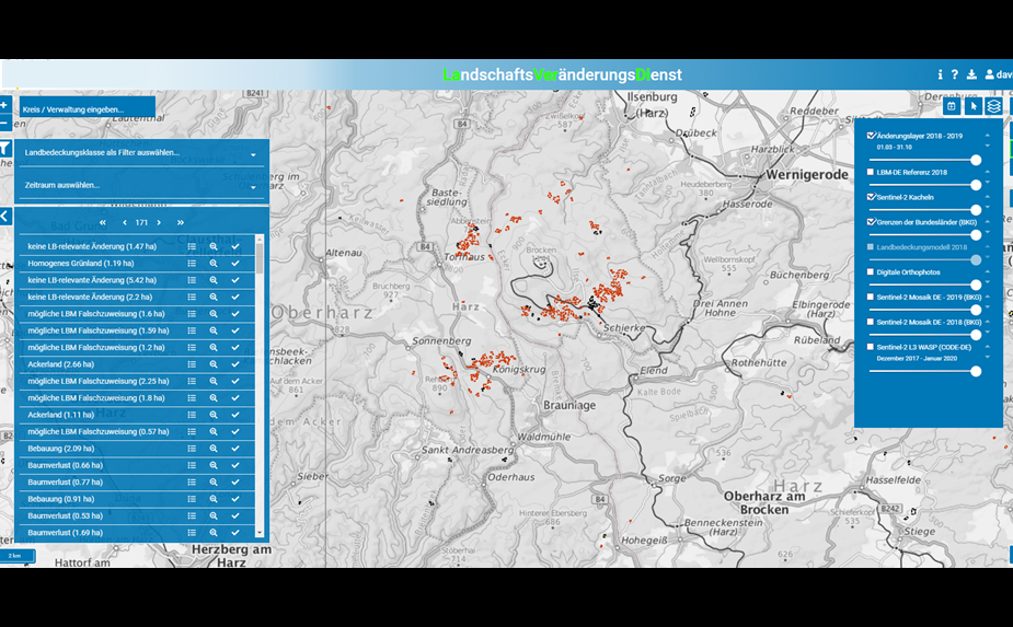
LaVerDi - Landschaftsveränderungsdienst - Web-Applikation
Der LandschaftsVeränderungsDienst (LaVerDi) ist eine Web-Anwendung des BKG. In der Anwendung werden Veränderungsflächen der Landbedeckung Deutschlands berechnet und jährlich zusammen mit weiteren Informationsebenen bereitgestellt. Abgeleitet werden die Flächen automatisch aus Fernerkundungsdaten des Copernicus Sentinel-2 Satelliten. Genauer werden NDVI-basierte Time Features der gleichen Periode zweier aufeinanderfolgender Referenzjahre (t0, t1) zum Monitoring von Veränderungen der Landbedeckung verwendet. Dazu findet eine klassenspezifische Veränderungsanalyse auf Basis des Landbedeckungsmodells Deutschland (LBM-DE) als räumliche und thematische Referenz statt. Technisch umgesetzt und betrieben wird LaVerDi auf der Copernicus Data and Exploitation Platform - Deutschland (CODE-DE).
INSPIRE
Identification
- File identifier
- CA4664C4-EED6-4AFE-A6C7-26ABBD699FDC XML
- Hierarchy level
- application
Online resource
Resource identifier
- Metadata language
- Deutsch
Encoding
Projection
Classification of data and services
Coupled resource
Coupled resource
Classification of data and services
Coupled resource
Coupled resource
Keywords
-
GEMET - Concepts, version 3.1
Other keywords
- Keywords
-
-
Bebaute Flächen
-
Copernicus
-
Feuchtflächen
-
homogenes Grünland
-
inhomogenes Grünland
-
Offene Flächen
-
Sentinel-2
-
Wälder und naturnahe Flächen
-
Wasserflächen
-
Grenzen
-
Geographic coverage
))
Temporal reference
Temporal extent
- Begin
- 2018-03-01T00:00:00.000+01:00
- End
- 2019-10-31T00:00:00.000+01:00
Temporal extent
- Date (Publication)
- 2021-05-15T00:00:00.000+02:00
Conformity
Conformity
Conformity
Conformity
Conformity
Conformity
Restrictions on access and use
- Access constraints
-
Das BKG stellt das Produkt Landschaftsveränderungsdienst (LaVerDi) Jedermann zu folgenden Nutzungsbedingungen zur Verfügung: https://sg.geodatenzentrum.de/web_public/gdz/lizenz/deu/Nutzungsbedingungen_LaVerDi.pdf
- Access constraints
-
Quellenvermerk: © Bundesamt für Kartographie und Geodäsie (2022), Datenquellen https://sg.geodatenzentrum.de/web_public/Datenquellen_LaVerDi.pdf
Responsible organization (s)
Contact for the resource
- Organisation name
-
Bundesamt für Kartographie und Geodäsie (BKG)
- Organisation name
-
Bundesamt für Kartographie und Geodäsie (BKG)
Responsible organization (s)
Contact for the resource
- Organisation name
-
Bundesamt für Kartographie und Geodäsie (BKG)
- Organisation name
-
Bundesamt für Kartographie und Geodäsie (BKG)
Metadata information
Contact for the metadata
- Organisation name
-
Bundesamt für Kartographie und Geodäsie (BKG)
- Date stamp
- 2026-05-05
- Metadata language
- Deutsch
SDS
Conformance class 1: invocable
Access Point URL
Endpoint URL
Technical specification
Conformance class 2: interoperable
Access constraints
Limitation
Use constraints
Limitation
Responsible custodian
Contact for the resource
Overviews
Spatial extent
Provided by
