 www.geodatenkatalog.de (S1L)
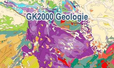
Geoscientific Map of Germany 1:2,000,000 - Geology
The digital GK2000 Geology represents the surface geology of Germany and adjacent regions at a scale of 1:2,000,000. The map includes 30 units differentiated according to their age of formation. It also contains information on the distribution of volcanic, plutonic and metamorphic rocks. Furthermore, the map shows tectonic line elements, marginal positions of the ice shield of the last glacial periods as well as the impact craters Nördlinger Ries and Steinheimer Becken.
|
|
Citation proposal
(2004) . Geoscientific Map of Germany 1:2,000,000 - Geology. https://gdk.gdi-de.org/geonetwork/srv/api/records/CBEB80C3-096A-43FF-8AAD-B1304BEE351D |
INSPIRE
Identification
- File identifier
- CBEB80C3-096A-43FF-8AAD-B1304BEE351D XML
- Hierarchy level
- dataset Dataset
Online resource
Resource identifier
- code
- 988520B0-9872-4E7A-8562-09653B2B5E20
- Metadata language
- ger German
- Spatial representation type
- Vector
Encoding
- Format
- Version
- n/a
- Format
- Shapefile
- Version
- n/a
Projection
Classification of data and services
- Topic category
-
- Geoscientific information
Classification of data and services
Coupled resource
Coupled resource
Classification of data and services
Coupled resource
Coupled resource
Keywords
- GEMET - INSPIRE themes, version 1.0 ( Theme )
-
- Geologie
- Geology
- GEMET - Concepts, version 2.4 ( Theme )
-
- tectonic
- Tektonik
- High-value dataset categories
-
- Erdbeobachtung und Umwelt
Other keywords
- Keywords ( Theme )
-
- Eisrandlagen
- Genese
- Oberflächengeologie
- Petrographie
- Stratigraphie
- opendata
- Keywords ( Place )
-
- Deutschland
Geographic coverage
N
S
E
W
))
Temporal reference
Temporal extent
Temporal extent
- Date ( Publication )
- 2004-09-30
Quality and validity
- Lineage
- -
- Denominator
- 2000000
Conformity
Conformity
Conformity
Conformity
Conformity
Conformity
- Explanation
- siehe dazu die angegebene Durchführungsbestimmung
Restrictions on access and use
- Access constraints
- Allgemeine Geschäftsbedingungen, s. https://www.bgr.bund.de/agb - General Terms and Conditions, s. https://www.bgr.bund.de/agb_en
- Access constraints
- Dieser Datensatz kann gemäß der "Nutzungsbestimmungen für die Bereitstellung von Geodaten des Bundes" (https://sg.geodatenzentrum.de/web_public/gdz/lizenz/geonutzv.pdf) genutzt werden.
- Access constraints
- {"id": "geoNutz/20130319", "name": "Nutzungsbestimmungen für die Bereitstellung von Geodaten des Bundes", "url": "https://sg.geodatenzentrum.de/web_public/gdz/lizenz/geonutzv.pdf", "quelle": "Bundesanstalt für Geowissenschaften und Rohstoffe (BGR)"}
Restrictions on access and use
Responsible organization (s)
Contact for the resource
- Organisation name
- Bundesanstalt für Geowissenschaften und Rohstoffe
- geologie.daten@bgr.de
Responsible organization (s)
Contact for the resource
- Organisation name
- Bundesanstalt für Geowissenschaften und Rohstoffe
- geologie.daten@bgr.de
Metadata information
Contact for the metadata
- Organisation name
- Bundesanstalt für Geowissenschaften und Rohstoffe (BGR)
- Date stamp
- 2024-04-26
- Metadata language
- German
- Character set
- utf8 UTF8
SDS
Conformance class 1: invocable
Access Point URL
Endpoint URL
Technical specification
Conformance class 2: interoperable
Coordinate reference system
Quality of Service
Access constraints
Limitation
Use constraints
Limitation
Responsible custodian
Contact for the resource
Conformance class 3: harmonized
Overviews
Provided by

Views
CBEB80C3-096A-43FF-8AAD-B1304BEE351D
Access to the portal
Read here the full details and access to the data.
Associated resources
Not available