 My GeoNetwork catalogue
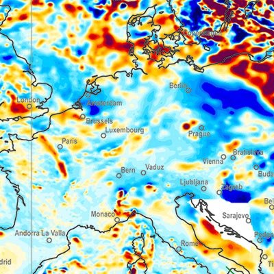
Earth Magnetic Anomaly Grid 1:35,000,000 (2 arc-minute resolution) (EMAG2)
A global Earth Magnetic Anomaly Grid (EMAG2) was compiled from satellite, ship and airborne magnetic measurements. (Maus et al., 2009) Over the continents and the Arctic we made use of exisiting magnetic anomaly grids, whereas original ship and airborne trackline data were processed over the rest of the oceans, wherever available. CHAMP satellite magnetic measurements provided the magnetic field at wavelengths above 330 km. The EMAG2 grid is available at http://geomag.org and http://ngdc.noaa.gov . Directional gridding Due to the sparsity of magnetic field measurements in the southern oceans, it is necessary to interpolate the magnetic field between tracklines. Our interpolation algorithm takes the direction of the magnetic lineations into account. Tje lineations are parallel to the isochrons, which are perpendicular to the gradient of the age of teh oceanic crust. We use the age grid of Müller et al. (2008). The magnetic field ad a given grid point is computet by Least Squares Collocation from the surrounding measurements. If the point is on land, we use an isotropic correlation function with Rc = 14 km correlation length. Over the oceans we use Rc = 56 km parallel to the isochrons and Rc = 14 km in the spreading direction. Measurements seperated from the grid point by an age discontinuity or a topographic feature are excluded from the collation.
INSPIRE
Identification
- File identifier
- CF387546-B217-43D3-8781-8BEF8250253B XML
- Hierarchy level
- Dataset
Online resource
Resource identifier
- code
-
B3CCFEA1-9E87-4593-B4AB-6D441AA752C1
- Metadata language
- English
- Spatial representation type
- Grid
Encoding
- Format
-
PDF
- Version
-
n/a
- Format
-
JPEG
- Version
-
n/a
- Format
-
TIFF
- Version
-
n/a
- Format
-
gedruckt
- Version
-
n/a
Projection
- code
- EPSG:4326
Classification of data and services
- Topic category
-
- Geoscientific information
Classification of data and services
Coupled resource
Coupled resource
Classification of data and services
Coupled resource
Coupled resource
Keywords
-
GEMET - INSPIRE themes, version 1.0
-
-
Geologie
-
-
GEMET - Concepts, version 2.4
-
-
geophysics
-
Geophysik
-
Other keywords
- Theme
-
-
Earth magnetic field
-
Erdmagnetfeld
-
Weltkarte
-
world map
-
- Place
-
-
Weltweit
-
Geographic coverage
))
Temporal reference
Temporal extent
Temporal extent
- Date (Publication)
- 2010-11-10
Quality and validity
- Lineage
-
Daten: NOAA, Boulder, CO, USA. Referenz: Maus, S., U. Barckhausen, et al. (2009), EMAG2: A 2-arc min resolution Earth Magnetic Anomaly Grid compiled from satellite, airborne, and ... , Geochem. Geophys. Geosyst., 10, doi: 10.1029/2009GC002471 - Data: NOAA, Boulder, CO, USA. Reference: Maus, S., U. Barckhausen, et al. (2009), EMAG2: A 2-arc min resolution Earth Magnetic Anomaly Grid compiled from satellite, airborne, and ... , Geochem. Geophys. Geosyst., 10, doi: 10.1029/2009GC002471
- Denominator
- 35000000
Conformity
Conformity
Conformity
Conformity
Conformity
Conformity
Restrictions on access and use
- Access constraints
- Es gelten keine Zugriffsbeschränkungen
- Access constraints
-
Allgemeine Geschäftsbedingungen, s. https://www.bgr.bund.de/agb - General Terms and Conditions, s. https://www.bgr.bund.de/agb_en
- Access constraints
-
Preis der gedruckten Karte: 13,83 EUR (zzgl. 7% MWSt. und Versandkosten) Weitere Informationen zur Bestellung beim Internationalen Landkartenhaus siehe https://www.bgr.bund.de/produktcenter-bestellhinweis-ILH
Responsible organization (s)
Contact for the resource
- Organisation name
-
Bundesanstalt für Geowissenschaften und Rohstoffe
Responsible organization (s)
Contact for the resource
- Organisation name
-
Bundesanstalt für Geowissenschaften und Rohstoffe
Metadata information
Contact for the metadata
- Organisation name
-
Bundesanstalt für Geowissenschaften und Rohstoffe (BGR)
- Date stamp
- 2025-02-12
- Metadata language
- English
- Character set
- UTF8
SDS
Conformance class 1: invocable
Access Point URL
Endpoint URL
Technical specification
Conformance class 2: interoperable
Access constraints
Limitation
Use constraints
Limitation
Responsible custodian
Contact for the resource
Overviews
Spatial extent
Provided by
