 www.geodatenkatalog.de (S1L)
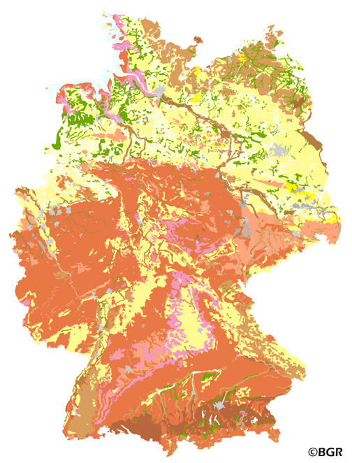
Soil types of topsoils in Germany 1:1,000,000
The map shows the distribution of typical soil types (soil texture) in the topsoils of Germany. Typical is used in the term of areally dominating. The map visualizes the results of the project that are documented in a BGR report (Bodenarten der Böden Deutschlands; BGR Archiv, Nr. 0127305). The soil texture data from the analysis of the particle size distribution for 16,132 sites in Germany were classified after the legend units of land use-stratified soil map of Germany 1: 1,000,000 (BÜK1000N V2.3) and mean soil texture were calculated. Considering the large heterogeneity in the data and the resulting uncertaintly in the precision for a site the depiction of the obtained soil texture is presented at the level of the soil types group, according to the German soil classification system (KA5).
|
|
Citation proposal
(2007) . Soil types of topsoils in Germany 1:1,000,000. https://gdk.gdi-de.org/geonetwork/srv/api/records/DADB8BB6-4A7A-4CB7-908D-EA0767B068D7 |
Simple
- Alternate title
- BOART1000OB
- Date ( Creation )
- 2007-07-05
- Date ( Publication )
- 2007-12-07
- Edition
- Version 2.0
- Identifier
- 410B839B-DCF2-45BE-8788-3C65BBEC2D59
Author
- Status
- completed Completed
Point of contact
Bundesanstalt für Geowissenschaften und Rohstoffe (BGR)
-
Stange, Florian, Dr.
Stilleweg 2
Hannover
30655
DE
- GEMET - INSPIRE themes, version 1.0 ( Theme )
-
- Boden
- Soil
- GEMET - Concepts, version 2.4 ( Theme )
-
- Bodenart
- Bodenauslaugung
- Bodenbearbeitung
- Bodenbelastung
- Bodenbildung
- Bodenbiologie
- Bodenchemie
- Bodendegradation
- Bodendekontamination
- Bodenerosion
- Bodenfeuchtigkeit
- Bodenfruchtbarkeit
- Bodenfunktion
- Bodengestaltung
- Bodenkarte
- Bodenluft
- Bodenmechanik
- Bodenmineralogie
- Bodennutzbarkeit
- Bodennutzung
- SGD-Liste ( Theme )
-
- Bodeneigenschaften
- Bodengefüge
- Bodengruppe
- Bodenhorizont
- bodenphysikalische Eigenschaften
- Bodenskelett
- Bodenverbreitung
- Durchlässigkeit
- effektive Durchwurzelungstiefe
- Freies Schlagwort ( Theme )
-
- Bodenausgangsgestein
- Bodengesellschaft
- Bodeninformationssystem
- Bodensystematik
- Fachinformationssystem
- inspireidentifiziert
- opendata
- Keywords ( Place )
-
- Bundesrepublik Deutschland
- Spatial scope
-
- National
- High-value dataset categories
-
- Erdbeobachtung und Umwelt
- Access constraints
- Other restrictions
- Use constraints
- Other restrictions
- Other constraints
- Allgemeine Geschäftsbedingungen, siehe https://www.bgr.bund.de/AGB - General terms and conditions, see https://www.bgr.bund.de/AGB_en. Die bereitgestellten Informationen sind bei Weiterverwendung wie folgt zu zitieren: Datenquelle: BOART1000OB V2.0, (C) BGR, Hannover, 2007.
- Other constraints
- Dieser Datensatz kann gemäß der "Nutzungsbestimmungen für die Bereitstellung von Geodaten des Bundes" (https://sg.geodatenzentrum.de/web_public/gdz/lizenz/geonutzv.pdf) genutzt werden.
- Other constraints
- {"id": "geoNutz/20130319", "name": "Nutzungsbestimmungen für die Bereitstellung von Geodaten des Bundes", "url": "https://sg.geodatenzentrum.de/web_public/gdz/lizenz/geonutzv.pdf", "quelle": "BOART1000OB V2.0, (C) BGR, Hannover, 2007"}
- Spatial representation type
- Vector
- Denominator
- 1000000
- Metadata language
- ger German
- Character set
- utf8 UTF8
- Topic category
-
- Geoscientific information
N
S
E
W
))
- Geographic identifier
- Regionalschlüssel / 000000000000
- Distribution format
-
- PDF (n/a )
- Shapefile (n/a )
- JPEG (n/a )
- PNG (n/a )
- TIFF (n/a )
- Transfer size
- 9
- OnLine resource
-
BOART1000OB (PDF)
BOART1000OB im Format Adobe Acrobat (Auflösung 600 dpi)
- Transfer size
- 7
- OnLine resource
-
BOART1000OB (Shapefile)
BOART1000OB im Format ESRI Shape
- Transfer size
- 22
- OnLine resource
-
BOART1000OB (JPEG)
BOART1000OB im Format JPEG (Auflösung 300 dpi)
- Transfer size
- 16
- OnLine resource
-
BOART1000OB (PNG)
BOART1000OB im Format PNG (Auflösung 150 dpi)
- Transfer size
- 19
- OnLine resource
-
BOART1000OB (TIFF)
BOART1000OB im Format TIFF (Auflösung 300 dpi)
- OnLine resource
-
BOART1000 Internetseite - BOART1000 Website
BOART1000 Internetseite - BOART1000 Website
- OnLine resource
-
Bericht über länderübergreifende Auswertungen von Punktinformationen im FISBo BGR -
Bericht über länderübergreifende Auswertungen von Punktinformationen im FISBo BGR -
- OnLine resource
-
Karte im BGR-Geoviewer
Karte im BGR-Geoviewer
- Hierarchy level
- Dataset
Conformance result
- Date ( Publication )
- 2010-12-08
- Explanation
- siehe dazu die angegebene Durchführungsbestimmung
- Statement
- Labor- und Profildatenbank im FISBo BGR; zusätzliche Datenbereitstellung durch die SGD (AG Boden).
gmd:MD_Metadata
- File identifier
- DADB8BB6-4A7A-4CB7-908D-EA0767B068D7 XML
- Metadata language
- German
- Character set
- utf8 UTF8
- Hierarchy level
- dataset Dataset
- Hierarchy level name
- Boden
- Date stamp
- 2024-04-23
- Metadata standard name
- INSPIRE Metadata Implementing Rules: Technical Guidelines based on EN ISO 19115 and EN ISO 19119
- Metadata standard version
- n/a
Point of contact
Overviews
Provided by

Views
DADB8BB6-4A7A-4CB7-908D-EA0767B068D7
Access to the portal
Read here the full details and access to the data.
Associated resources
Not available