 www.geodatenkatalog.de (S1L)
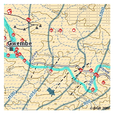
Hydrogeological Map of Zambia (HYGMAP ZAMBIA), Southern Province - "Southern Kariba Lake and Kalomo" 1:250,000
Zambia faces an increasing demand of industrial- and drinking water. In the field Zambia faces an increasing demand of industrial- and drinking water. In the fields of water supply and management, the Zambian government cooperates with BGR as one of the implementing agencies of the German Development Cooperation and other partners. The project "Groundwater Resources for Southern Province" aims at solutions for the southern parts of the country in which surface water is scarce and only temporarily available. Accurate and updated information about quality and quantity on both surface and groundwater resources is required to regulate its use and to establish an integrated and sustainable management of the Nation’s water resources. One result of data research is reflected in the GIS-based Hydrogeological Map "Southern Kariba Lake and Kalomo", scale 1:250,000.
The contents of the maps comprise:
- Topography including administrative boundaries, transport, villages, towns, health centres and schools, surface elevation
- Hydrography including rivers and wetlands
- Surface catchment and subcatchment boundaries
- Aquifers
- Groundwater elevation contours and direction of groundwater flow
- Water points such as boreholes and wells and thermal springs
- Lithology and geological structures (faults, etc.)
- Rainfall Distribution (Insert Map)
- Sheet map of available hydrogeological map sheets of Southern Province, Zambia
(scale 1:250,000)
Additional Information:
For Southern Province 2 adjacent or overlapping hydrogeological maps at scale 1:250.000 and one map at scale 1:100,000 (digital and printed version) are available.
The printed version is only available as whole package (4 maps and 2 booklets).
|
|
Citation proposal
. Hydrogeological Map of Zambia (HYGMAP ZAMBIA), Southern Province - "Southern Kariba Lake and Kalomo" 1:250,000. https://gdk.gdi-de.org/geonetwork/srv/api/records/E1008077-D790-465E-99BA-F5821052DFD5 |
INSPIRE
Identification
- File identifier
- E1008077-D790-465E-99BA-F5821052DFD5 XML
- Hierarchy level
- dataset Dataset
Online resource
Resource identifier
- code
- 3D74D8C5-BCDB-4BE4-87E1-16F06A7F38AB
- Metadata language
- eng English
- Spatial representation type
- Grid
Encoding
- Format
- Version
- n/a
- Format
- JPEG
- Version
- n/a
- Format
- JPEG
- Version
- n/a
Projection
Classification of data and services
- Topic category
-
- Geoscientific information
Classification of data and services
Coupled resource
Coupled resource
Classification of data and services
Coupled resource
Coupled resource
Keywords
- GEMET - INSPIRE themes, version 1.0 ( Theme )
-
- Geologie
- Geology
- GEMET - Concepts, version 2.4 ( Theme )
-
- Groundwater
- Grundwasser
- Hydrogeologie
- Hydrogeology
Other keywords
- Keywords ( Theme )
-
- Aquifer
- Bohrlöcher
- Borehole
- Catchments
- Department of Water Affairs Sambia (DWA)
- Groundwater features
- Groundwater flow direction
- Groundwater resources
- Grundwasserbestand
- Grundwassergleichen
- Grundwasserqualität
- Grundwasserressourcen
- Hydrochemie
- Integrated Water Resource Management System
- IWRMS
- Lithologie
- Lithology
- Ministry of Energy and Water Development Zambia
- Technische Zusammenarbeit
- Thermal spring
- Wassereinzugsgebiet
- Wasserressourcenmanagement
- Keywords ( Place )
-
- Sambia
- Keywords ( Place )
-
- Südprovinz
Geographic coverage
))
Temporal reference
Temporal extent
Temporal extent
- Date ( Creation )
- 2007-12-31
Quality and validity
- Lineage
- Topograph. Karten 1:250.000, 1973-1992, Surveyor-General Lusaka; DEM, abgeleitet von SRTM-Daten, 2002; Geol. Karten 1:100.000, 1:250.000, 1:1.000.000, Geological Survey Department Lusaka; Grundwasser-Datenbank, Department of Water Affairs Lusaka, 2007 - Topographic Maps 1:250,000, 1973-1992, Surveyor-General, Lusaka; DEM, based on SRTM-data, 2002; Geological Maps 1:100,000, 1:250,000, 1:1,000,000, Geological Survey Department, Lusaka; Groundwater Database, Department of Water Affairs, Lusaka; 2007
- Denominator
- 250000
Conformity
Conformity
Conformity
Conformity
Conformity
Conformity
Restrictions on access and use
- Access constraints
- Allgemeine Geschäftsbedingungen, s. https://www.bgr.bund.de/agb - General Terms and Conditions, s. https://www.bgr.bund.de/agb_en
Restrictions on access and use
Responsible organization (s)
Contact for the resource
- Organisation name
- Bundesanstalt für Geowissenschaften und Rohstoffe
- gresp@iconnect.zm
Responsible organization (s)
Contact for the resource
- Organisation name
- Bundesanstalt für Geowissenschaften und Rohstoffe
- gresp@iconnect.zm
Metadata information
Contact for the metadata
- Organisation name
- Bundesanstalt für Geowissenschaften und Rohstoffe (BGR)
- Date stamp
- 2021-12-13
- Metadata language
- German
- Character set
- utf8 UTF8
SDS
Conformance class 1: invocable
Access Point URL
Endpoint URL
Technical specification
Conformance class 2: interoperable
Coordinate reference system
Quality of Service
Access constraints
Limitation
Use constraints
Limitation
Responsible custodian
Contact for the resource
Conformance class 3: harmonized
Overviews
Provided by
