 www.geodatenkatalog.de (S1L)
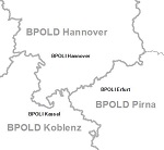
Behördenzuständigkeitsbereiche
Es werden die Flächen der Zuständigkeitsbereiche von Bundespolizei (Direktionen und Inspektionen), der Staatsanwaltschaften, des THW (Landesverbände und Regionalstellen) und des Zolls (Hauptzollämter, Agrardieselvergütung, Ausfuhrzollstellen, Finanzkontrolle und Schwarzarbeit, Kfz-Steuer, Kfz-Steuer Festsetzungsstellen, Straf- und Bußgeldstellen, Verwertungsstellen, Vollstreckungsbezirke, Zollfahndungsämter) basierend auf der VG250 oder den Postleitzahlgebieten dargestellt.
|
|
Citation proposal
. Behördenzuständigkeitsbereiche. https://gdk.gdi-de.org/geonetwork/srv/api/records/E54770AF-BDC5-45AC-BC00-4455A2E8186A |
INSPIRE
Identification
- File identifier
- E54770AF-BDC5-45AC-BC00-4455A2E8186A XML
- Hierarchy level
- dataset Dataset
Online resource
Resource identifier
- Metadata language
- German
- Spatial representation type
- Vector
Encoding
- Format
- Shapefiles
Projection
- code
- DE_ETRS89 / UTM
Classification of data and services
- Topic category
-
- Boundaries
Classification of data and services
Coupled resource
Coupled resource
Classification of data and services
Coupled resource
Coupled resource
Keywords
- GEMET - Concepts, version 3.1 ( Theme )
Other keywords
- Keywords
-
- Bundespolizei
- Bpol
- Technisches
- Hilfswerk
- THW
- Zuständigkeitsbereich
- Zoll
Geographic coverage
N
S
E
W
))
Temporal reference
Temporal extent
Temporal extent
- Date ( Creation )
- 2018-12-03T00:00:00.000+01:00
- Date ( Revision )
- 2023-12-31T00:00:00.000+01:00
- Date ( Revision )
- 2024-12-31T00:00:00.000+01:00
Quality and validity
- Lineage
- siehe Produktbeschreibung
- Denominator
- 250000
Conformity
Conformity
Conformity
Conformity
Conformity
Conformity
Restrictions on access and use
- Access constraints
- Es gelten Zugriffsbeschränkungen. Für den Erwerb von Nutzungsrechten wenden Sie sich deshalb bitte an die Zentrale Stelle Geotopographie der AdV (ZSGT) / Dienstleistungszentrum (DLZ) des Bundesamtes für Kartographie und Geodäsie: https://www.bkg.bund.de/DE/Service/Kontakt/kontakt.html.
- Access constraints
- Die Daten sind urheberrechtlich geschützt. Auf Grundlage des Vertrages mit dem Datenanbieter werden die Daten je nach vertraglicher Ausgestaltung allen oder ausgewählten Bundesbehörden und weiteren Nutzungsberechtigten im Sinne des § 4 V GeoBund geldleistungsfrei zur Verfügung gestellt. Der Quellenvermerk ist zu beachten.
- Access constraints
- Quellenvermerk: © BKG (Jahr des letzten Datenbezugs), Datenquellen: https://sg.geodatenzentrum.de/web_public/gdz/datenquellen/datenquellen_bzb.pdf
Restrictions on access and use
Responsible organization (s)
Contact for the resource
- Organisation name
- Bundesamt für Kartographie und Geodäsie (BKG)
- dlz@bkg.bund.de
- Organisation name
- Bundesamt für Kartographie und Geodäsie (BKG)
- mailbox@bkg.bund.de
Responsible organization (s)
Contact for the resource
- Organisation name
- Bundesamt für Kartographie und Geodäsie (BKG)
- dlz@bkg.bund.de
- Organisation name
- Bundesamt für Kartographie und Geodäsie (BKG)
- mailbox@bkg.bund.de
Metadata information
Contact for the metadata
- Organisation name
- Bundesamt für Kartographie und Geodäsie (BKG)
- dlz@bkg.bund.de
- Date stamp
- 2025-05-16
- Metadata language
- German
SDS
Conformance class 1: invocable
Access Point URL
Endpoint URL
Technical specification
Conformance class 2: interoperable
Coordinate reference system
Quality of Service
Access constraints
Limitation
Use constraints
Limitation
Responsible custodian
Contact for the resource
Conformance class 3: harmonized
Overviews
Provided by

Views
E54770AF-BDC5-45AC-BC00-4455A2E8186A
Access to the portal
Read here the full details and access to the data.
Associated resources
Not available