 www.geodatenkatalog.de (S3L)
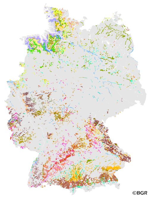
Land use-stratified soil map of Germany at scale 1:1,000,000 - part grassland soils
The Land use-stratified soil map of Germany 1:1,000,000 (BUEK1000N), Version 2.31, part grassland soils, was subdivided according to the main land cover types (forest, cropland and grassland) using the 1990 CORINE Land Cover data. However, it cannot be expected that the legend of this soil map is valid for the CORINE areas (in this project processed as vector data with the resolution of ca. 0,25 km2) rather than for larger patches (ca. 4 km2). Thus, the land cover data had to be generalized. The original land-cover classes were first aggregated into 14 combined classes, then generalized to at least 4 km2 patches, and finally intersected with the soil map units. The unchanged original soil map units were thus geometrically subdivided by land cover. Soil regions, soil landscapes and European climatic zones were also considered in order to stratify the legend of this new digital database. In another working step, the descriptions of the soil legend units were re-written in order to distinguish and to describe typical soil types and soil profiles under forest, cropland and grassland. For that, data from the BGR soil profile data base and from higher resolution soil maps as well as soil profiles from the national forest soil condition monitoring were evaluated. The results are stored in a relational database which is part of the BGR soil information system “FISBo BGR”. An additional, 54-page booklet with explanations for BUEK1000N can be purchased at the GeoCenter Touristik Medien Service GmbH in D-70565 Stuttgart.
|
|
Citation proposal
(2013) . Land use-stratified soil map of Germany at scale 1:1,000,000 - part grassland soils. https://gdk.gdi-de.org/geonetwork/srv/api/records/E8EE6615-3C14-432D-B636-B86A673294ED |
INSPIRE
Identification
- File identifier
- E8EE6615-3C14-432D-B636-B86A673294ED XML
- Hierarchy level
- dataset Dataset
Online resource
Resource identifier
- code
- 4B54EA2C-E0A2-4224-8525-10CC0DBFA1FC
- Metadata language
- ger German
- Spatial representation type
- Vector
Encoding
- Format
- Version
- n/a
- Format
- Shapefile
- Version
- n/a
- Format
- JPEG
- Version
- n/a
- Format
- PNG
- Version
- n/a
- Format
- MS Access
- Version
- n/a
- Format
- TIFF
- Version
- n/a
Projection
Classification of data and services
- Topic category
-
- Geoscientific information
Classification of data and services
Coupled resource
Coupled resource
Classification of data and services
Coupled resource
Coupled resource
Keywords
- GEMET - INSPIRE themes, version 1.0 ( Theme )
-
- Boden
- Soil
- GEMET - Concepts, version 2.4 ( Theme )
-
- Bodenart
- Bodenauslaugung
- Bodenbearbeitung
- Bodenbelastung
- Bodenbildung
- Bodenbiologie
- Bodenchemie
- Bodendegradation
- Bodendekontamination
- Bodenerosion
- Bodenfeuchtigkeit
- Bodenfruchtbarkeit
- Bodenfunktion
- Bodengestaltung
- Bodengüte
- Bodenkarte
- Bodenluft
- Bodenmechanik
- Bodenmineralogie
- Bodennutzbarkeit
- Bodennutzung
- SGD-Liste ( Theme )
-
- ackerbauliches Ertragspotential
- Bodeneigenschaften
- Bodengefüge
- Bodengruppe
- Bodenhorizont
- bodenphysikalische Eigenschaften
- Bodenskelett
- Bodenverbreitung
- Durchlässigkeit
- effektive Durchwurzelungstiefe
Other keywords
- Keywords ( Theme )
-
- Bodenausgangsgestein
- Bodenform
- Bodengesellschaft
- Bodeninformationssystem
- Bodenprofil
- Bodensubstrat
- Bodensystematik
- Bodentyp
- Fachinformationssystem
- Keywords ( Place )
-
- Bundesrepublik Deutschland
Geographic coverage
N
S
E
W
))
Temporal reference
Temporal extent
Temporal extent
- Date ( Creation )
- 2005-11-09
- Date ( Publication )
- 2013-02-22
Quality and validity
- Lineage
- BÜK1000N V1.3 (BGR), Bodenprofile der BZE (BFH), Bodenprofile der SGD der Länder. Gesamten Datensatz um 150 Meter nach Westen und um 50 Meter nach Süden verschoben (PROJECT), teilweise Übernahme von Gewässerflächen aus dem aktuellen DLM1000 (BKG).
- Denominator
- 1000000
Conformity
Conformity
Conformity
Conformity
Conformity
Conformity
Restrictions on access and use
- Access constraints
- Allgemeine Geschäftsbedingungen, siehe https://www.bgr.bund.de/AGB - General terms and conditions, see https://www.bgr.bund.de/AGB_en. Die bereitgestellten Informationen sind bei Weiterverwendung wie folgt zu zitieren: Datenquelle: BÜK1000N - Auszug Grünlandböden V2.31, (C) BGR, Hannover, 2013.
Restrictions on access and use
Responsible organization (s)
Contact for the resource
- Organisation name
- Bundesanstalt für Geowissenschaften und Rohstoffe (BGR)
- fis.bo@bgr.de
Responsible organization (s)
Contact for the resource
- Organisation name
- Bundesanstalt für Geowissenschaften und Rohstoffe (BGR)
- fis.bo@bgr.de
Metadata information
Contact for the metadata
- Organisation name
- Bundesanstalt für Geowissenschaften und Rohstoffe (BGR)
- Date stamp
- 2025-08-11
- Metadata language
- German
- Character set
- utf8 UTF8
SDS
Conformance class 1: invocable
Access Point URL
Endpoint URL
Technical specification
Conformance class 2: interoperable
Coordinate reference system
Quality of Service
Access constraints
Limitation
Use constraints
Limitation
Responsible custodian
Contact for the resource
Conformance class 3: harmonized
Overviews
Provided by

Views
E8EE6615-3C14-432D-B636-B86A673294ED
Access to the portal
Read here the full details and access to the data.
Associated resources
Not available