 My GeoNetwork catalogue
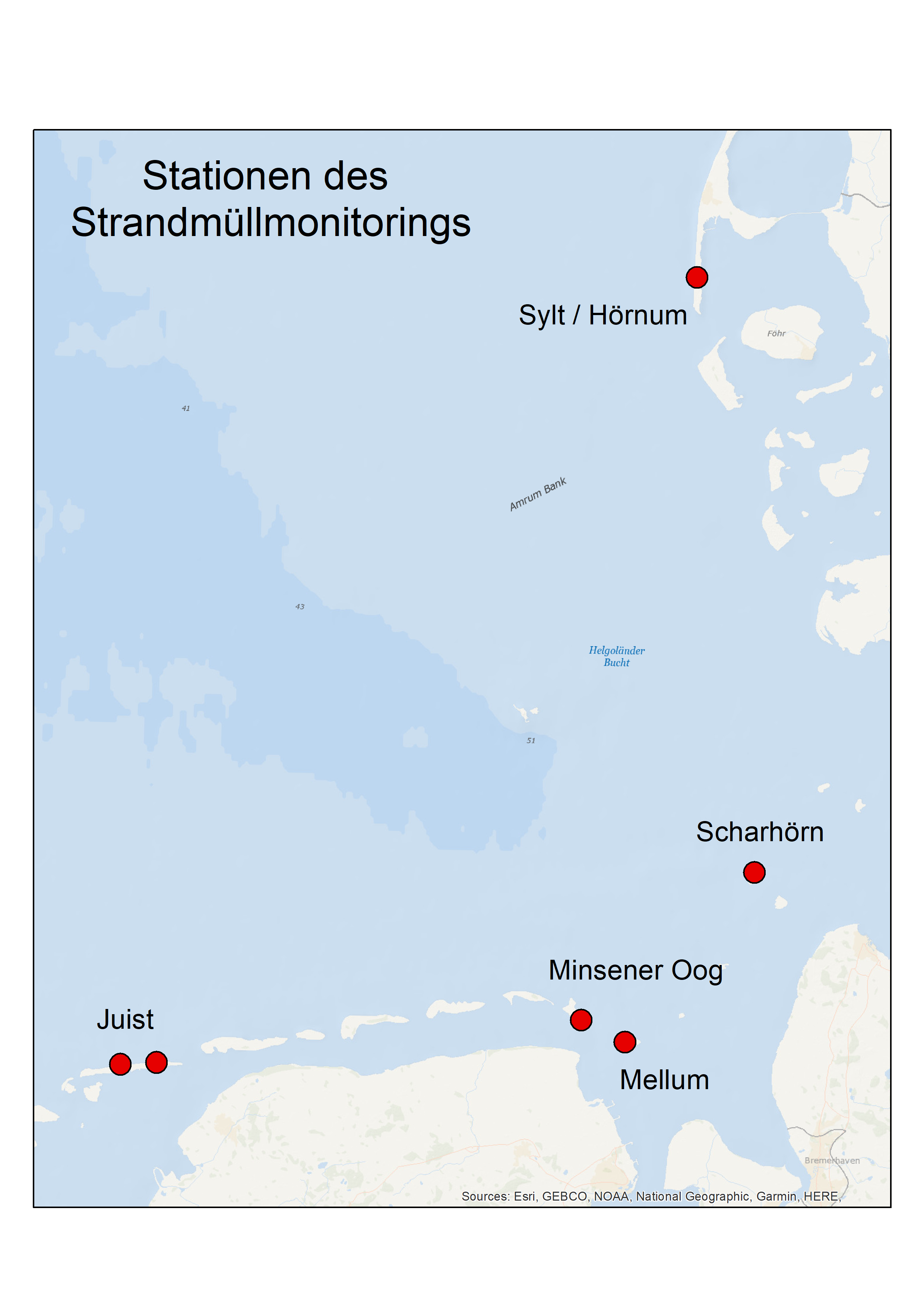
(WMS) - Strandmüllmonitoring an der deutschen Nordseeküste (LKN.SH - NPV)
Darstellungs-Dienst der zusammengeführte Daten des Strandmüllmonitorings der schleswig-holsteinischen, hamburgischen und niedersächsischen Nordseeküste. Das Strandmüllmonitoring erfolgt nach der OSPAR Beach Litter Guideline (2010). Es werden dabei bei bis zu 4 Erfassungen pro Monitoringjahr alle Müllteile auf vorgegebenen 100m-Transekten erfasst. Ein Monitoringjahr umfasst alle Erfassungen von Anfang Dezember des vorhergehenden Jahres bis Ende November des genannten Jahres.
Bei den hier bereitgestellten Daten handelt es sich sowohl um die geprüfte Rohdaten (Layer:Strandmüllmonitoring (MDI_MM_BL_WFS) als auch um aggregierte Daten:
Mittlere Anzahl Müllteile 2012-2017 (BL_ges_1217),
Mittlere Anzahl Müllteile 2018 (BL_ges_2018),
Mittlerer Anteil Plastik 2012-2017 (BL_Pla_1217),
Median Müllteile 2012-2017 (BL_MED_ges_1217).
Weitere Informationen: https://www.ospar.org/work-areas/eiha/marine-litter/assessment-of-marine-litter
INSPIRE
Identification
- File identifier
- F57F829B-FF49-4C2B-9F2E-99C33CEC3EF3 XML
- Hierarchy level
- Service
Online resource
- Protocol
- OGC Web Map Service
Resource identifier
Encoding
- Format
-
Shapefiles
- Version
-
10.0
- Format
-
WMS
- Version
-
1.3.0 1.1.1
- Specification
-
OpenGIS Web Map Service (WMS) Implementation Specification
- Format
-
WFS
- Version
-
1.1.0 1.0.0 2.0.0
- Specification
-
OpenGIS Web Feature Service (WFS) Implementation Specification
Projection
Classification of data and services
- Service Type
- view
- Coupling Type
- Mixed
Coupled resource
Coupled resource
Classification of data and services
- Service Type
- view
- Coupling Type
- Mixed
Coupled resource
Coupled resource
Keywords
-
GEMET - INSPIRE themes, version 1.0
-
-
Ozeanografisch-geografische Kennwerte
-
Umweltüberwachung
-
-
Service Classification, version 1.0
-
-
infoMapAccessService
-
Other keywords
- Keywords
-
-
Umwelt und Klima
-
D10
-
MSRL
-
GDI-SH
-
msrlrelevant
-
Umweltüberwachung
-
EU-Richtlinie
-
Meeresstrategie-Rahmenrichtlinie
-
Strandmüllmonitoring
-
Müll
-
MDI-DE
-
- Keywords
-
-
inspireidentifiziert
-
Geographic coverage
))
Temporal reference
Temporal extent
Temporal extent
- Begin
- 2012-01-01T00:00:00.000+01:00
- End
- 2017-12-31T00:00:00.000+01:00
- Date (Creation)
- 2019-06-20T00:00:00.000+02:00
- Date (Publication)
- 2019-06-20T00:00:00.000+02:00
- Date (Revision)
- 2023-10-10T00:00:00.000+02:00
Conformity
Conformity
Conformity
Conformity
Conformity
Conformity
- Explanation
-
Die Qualität der Daten entspricht den Datenspezifikationen.
- Explanation
-
Die Qualität der Daten entspricht den Datenspezifikationen.
Restrictions on access and use
- Access constraints
-
Datenlizenz Deutschland Namensnennung 2.0
- Access constraints
-
Quellenvermerk: LKN SH Nationalparkverwaltung
- Access constraints
-
{"id":"dl-by-de/2.0","name":"Datenlizenz Deutschland Namensnennung 2.0","url":" https://www.govdata.de/dl-de/by-2-0","quelle":"LKN SH Nationalparkverwaltung"}
- Access constraints
- Es gelten keine Zugriffsbeschränkungen
Responsible organization (s)
Contact for the resource
- Organisation name
-
Landesbetrieb für Küstenschutz, Nationalpark und Meeresschutz Schleswig-Holstein
- Organisation name
-
Landesbetrieb für Küstenschutz, Nationalpark und Meeresschutz Schleswig-Holstein
Responsible organization (s)
Contact for the resource
- Organisation name
-
Landesbetrieb für Küstenschutz, Nationalpark und Meeresschutz Schleswig-Holstein
- Organisation name
-
Landesbetrieb für Küstenschutz, Nationalpark und Meeresschutz Schleswig-Holstein
Metadata information
Contact for the metadata
- Organisation name
-
Landesbetrieb für Küstenschutz, Nationalpark und Meeresschutz Schleswig-Holstein
- Date stamp
- 2026-02-25
- Metadata language
- Deutsch
SDS
Conformance class 1: invocable
- Pass
- Yes
- Pass
- Yes
Access Point URL
Endpoint URL
Technical specification
- Date
- Explanation
-
Die Qualität der Daten entspricht den Datenspezifikationen.
- Date
- Explanation
-
Die Qualität der Daten entspricht den Datenspezifikationen.
Conformance class 2: interoperable
Access constraints
- Access constraints
- Other restrictions
- Other constraints
- Es gelten keine Zugriffsbeschränkungen
Limitation
Use constraints
Limitation
- string
-
Datenlizenz Deutschland Namensnennung 2.0
- string
-
Quellenvermerk: LKN SH Nationalparkverwaltung
- string
-
{"id":"dl-by-de/2.0","name":"Datenlizenz Deutschland Namensnennung 2.0","url":" https://www.govdata.de/dl-de/by-2-0","quelle":"LKN SH Nationalparkverwaltung"}
Responsible custodian
Contact for the resource
Conformance class 3: harmonized
Contains Operations
- Operation Name
-
GetCapabilities
- Distributed Computing Platforms
- Web services
Contains Operations
- Operation Name
-
GetMap
- Distributed Computing Platforms
- Web services
Contains Operations
- Operation Name
-
GetFeatureInfo
- Distributed Computing Platforms
- Web services
Overviews
Spatial extent
Provided by
