 www.geodatenkatalog.de (S3L)
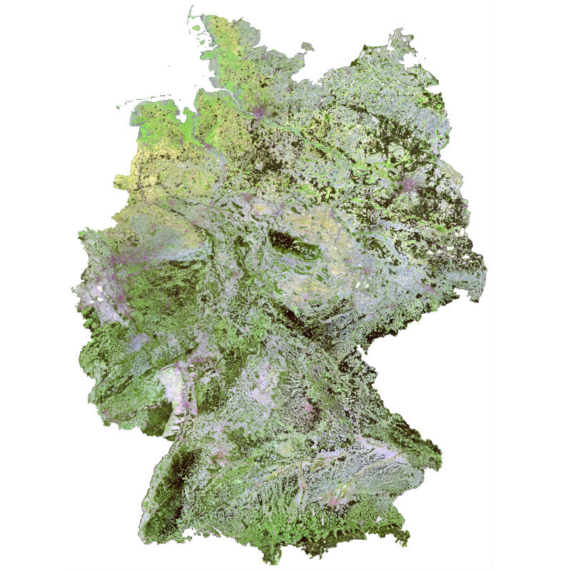
SCMaP - Landsat - Germany, 1984-2014
The Soil Composite Mapping Processor (SCMaP) is a new approach designed to make use of per-pixel compositing to overcome the issue of limited soil exposure due to vegetation. Three primary product levels are generated that will allow for a long term assessment and distribution of soils that include the distribution of exposed soils, a statistical information related to soil use and intensity and the generation of exposed soil reflectance image composites. The resulting composite maps provide useful value-added information on soils with the exposed soil reflectance composites showing high spatial coverage that correlate well with existing soil maps and the underlying geological structural regions.
|
|
Citation proposal
German Aerospace Center (DLR). SCMaP - Landsat - Germany, 1984-2014. https://gdk.gdi-de.org/geonetwork/srv/api/records/a1543075-f6a6-47ac-b45c-cece50778dc0 |
INSPIRE
Identification
- File identifier
- a1543075-f6a6-47ac-b45c-cece50778dc0 XML
- Hierarchy level
- Dataset
Online resource
- Protocol
- WWW:LINK-1.0-http--link
- Protocol
- WWW:LINK-1.0-http--link
- Protocol
- OGC:WMS
- Protocol
- OGC:WMS
- Protocol
- OGC:WMS
- Protocol
- OGC:WMS
- Protocol
- OGC:WMS
- Protocol
- OGC:WMS
- Protocol
- OGC:WMS
- Protocol
- OGC:WMS
- Protocol
- WWW:LINK-1.0-http--link
- Protocol
- WWW:LINK-1.0-http--link
- Protocol
- WWW:LINK-1.0-http--link
- Protocol
- WWW:LINK-1.0-http--link
Resource identifier
- Metadata language
- eng
- Spatial representation type
- Grid
Encoding
Projection
- code
- WGS 84 (EPSG:4326)
Classification of data and services
- Topic category
-
- Geoscientific information
Classification of data and services
Coupled resource
Coupled resource
Classification of data and services
Coupled resource
Coupled resource
Keywords
- GEMET - INSPIRE themes, version 1.0 ( Theme )
-
- Soil
Other keywords
- Keywords
-
- Landsat
- Soil mapping
- Image composites
- automated processors
- top soil analysis
- time series
- SCMaP
- Germany
Geographic coverage
N
S
E
W
))
Temporal reference
Temporal extent
Temporal extent
- Date ( Creation )
- 2018-11-17T00:00:00
Quality and validity
- Lineage
- Input data: Landsat 4, 5 and 7.
- Denominator
- 60000
Conformity
Conformity
Conformity
Conformity
Conformity
Conformity
- Explanation
- See the referenced specification.
Restrictions on access and use
- Access constraints
- License
- Access constraints
- Nutzungsbedingungen: License, https://creativecommons.org/licenses/by-nc-sa/4.0/
- Access constraints
-
{"id": "other-open",
"name": "Andere offene Lizenz",
"url": "http://dcat-ap.de/def/licenses/other-open",
"quelle": "Copyright DLR (year of production)"}
Restrictions on access and use
Responsible organization (s)
Contact for the resource
- Organisation name
- German Aerospace Center (DLR)
- uta.heiden@dlr.de
- Organisation name
- German Aerospace Center (DLR)
- geoservice@dlr.de
Responsible organization (s)
Contact for the resource
- Organisation name
- German Aerospace Center (DLR)
- uta.heiden@dlr.de
- Organisation name
- German Aerospace Center (DLR)
- geoservice@dlr.de
Metadata information
Contact for the metadata
- Organisation name
- German Aerospace Center (DLR)
- geoservice@dlr.de
- Date stamp
- 2024-11-11T08:45:24
- Metadata language
- English
- Character set
- UTF8
SDS
Conformance class 1: invocable
Access Point URL
Endpoint URL
Technical specification
Conformance class 2: interoperable
Coordinate reference system
Quality of Service
Access constraints
Limitation
Use constraints
Limitation
Responsible custodian
Contact for the resource
Conformance class 3: harmonized
Overviews
large_thumbnail
thumbnail
Provided by

Views
a1543075-f6a6-47ac-b45c-cece50778dc0
Access to the portal
Read here the full details and access to the data.
Associated resources
Not available